Property Record
101 Keith St, Clemson, SC 29631
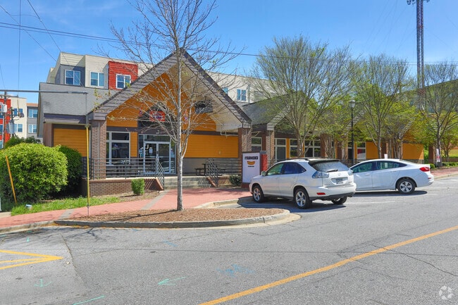

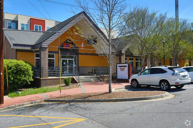
Property Detail
101 Keith St
4044-20-72-9291
101 KEITH ST PLAT 45/169B, PLAT 521/11A
Restaurantbuilding
Pickens
GENERAL CO
South Carolina
B and X Area of moderate flood hazard, usually the area between the limits of the 100-year and 500-year floods.
0.31 AC
2025
Pickens County
2025
Greenville/Spartanburg
011205
Greenville-Anderson-Greer, SC
3,776 SF
NEARBY LISTINGS FOR SALE OR LEASE
-
-
View all Clemson listings for sale on LoopNet.com
DEMOGRAPHICS near 101 Keith St
1 mile
3 mile
5 mile
2025 Total Population
7,132
25,696
44,011
2030 Population
7,309
26,546
45,715
Pop Growth 2025-2030
+ 2.48%
+ 3.31%
+ 3.87%
Average Age
29
32
35
2025 Total Households
2,467
9,035
16,943
HH Growth 2025-2030
+ 2.55%
+ 3.86%
+ 4.38%
Median Household Inc
$39,757
$50,707
$54,386
Avg Household Size
2.40
2.30
2.30
2025 Avg HH Vehicles
2.00
2.00
2.00
Median Home Value
$290,305
$362,258
$290,434
Median Year Built
1989
1989
1990
Nearby Places
Map Layers
Map Styles
 Street
 Aerial
Transit
 Traffic
 Biking
Places
Listings with unknown addresses are not visible on the map
- Restaurants
- Banks
- Shops
- Fitness
- Groceries
PUBLIC TRANSPORTATION
COMMUTER RAIL
Drive
Walk
Distance
2 min
12 min
0.6 mi
SALE & LEASE HISTORY
LISTING DATE
SALE/LEASE

Mar 21, 2017
For Sale
Feb 22, 2017
For Lease
Nearby Properties
Address
Land Use
TOTAL SIZE
Lot Size
Zoning
Address
Land Use
TOTAL SIZE
Lot Size
Zoning
3,224.70 AC
NOT ZONED
Address
Land Use
TOTAL SIZE
Lot Size
Zoning
21,573 SF
4.91 AC
CP 2 COMMU
Address
Land Use
TOTAL SIZE
Lot Size
Zoning
259,277 SF
3.39 AC
PD17
Address
Land Use
TOTAL SIZE
Lot Size
Zoning
52,520 SF
4.71 AC
CP 2 COMMU
Address
Land Use
TOTAL SIZE
Lot Size
Zoning
15,783 SF
1.43 AC
RM 4 MULTI
Address
Land Use
TOTAL SIZE
Lot Size
Zoning
26,864 SF
0.98 AC
GC
Address
Land Use
TOTAL SIZE
Lot Size
Zoning
3,985 SF
56.58 AC
Address
Land Use
TOTAL SIZE
Lot Size
Zoning
61,130 SF
19.26 AC
PD
Address
Land Use
TOTAL SIZE
Lot Size
Zoning
3,564 SF
1.72 AC
RM 4 MULTI
Address
Land Use
TOTAL SIZE
Lot Size
Zoning
6,574 SF
0.50 AC
RLC
Address
Land Use
TOTAL SIZE
Lot Size
Zoning
7,692 SF
0.40 AC
RIL
Address
Land Use
TOTAL SIZE
Lot Size
Zoning
24,882 SF
12.94 AC
PD
Address
Land Use
TOTAL SIZE
Lot Size
Zoning
54,420 SF
9.52 AC
PD16
Address
Land Use
TOTAL SIZE
Lot Size
Zoning
3,712 SF
1.55 AC
RM 4 MULTI
Address
Land Use
TOTAL SIZE
Lot Size
Zoning
185,383 SF
2.52 AC
GENERAL CO
Address
Land Use
TOTAL SIZE
Lot Size
Zoning
119,175 SF
2.11 AC
RM 3 MULTI
Address
Land Use
TOTAL SIZE
Lot Size
Zoning
267,298 SF
1.68 AC
GC
Address
Land Use
TOTAL SIZE
Lot Size
Zoning
9,112 SF
10.93 AC
RM 3 MULTI
Address
Land Use
TOTAL SIZE
Lot Size
Zoning
4.97 AC
PD
Address
Land Use
TOTAL SIZE
Lot Size
Zoning
6,000 SF
0.99 AC
Address
Land Use
TOTAL SIZE
Lot Size
Zoning
17 AC
RIL RESEAR
Address
Land Use
TOTAL SIZE
Lot Size
Zoning
84,530 SF
5.10 AC
CP 2 COMMU
Address
Land Use
TOTAL SIZE
Lot Size
Zoning
2,498 SF
8.27 AC
CP2
Address
Land Use
TOTAL SIZE
Lot Size
Zoning
22,722 SF
12.68 AC
PD
Address
Land Use
TOTAL SIZE
Lot Size
Zoning
36.40 AC
RM 1 TWO F
Address
Land Use
TOTAL SIZE
Lot Size
Zoning
42,049 SF
6.26 AC
PD
Address
Land Use
TOTAL SIZE
Lot Size
Zoning
54,244 SF
1.17 AC
RIL
Address
Land Use
TOTAL SIZE
Lot Size
Zoning
11.42 AC
Address
Land Use
TOTAL SIZE
Lot Size
Zoning
43,916 SF
0.25 AC
C
Address
Land Use
TOTAL SIZE
Lot Size
Zoning
69,132 SF
2.21 AC
CP2
The World's #1 Commercial Real Estate Marketplace
Connect with us
© 2026 CoStar Group
The information above has been obtained from sources believed reliable. While we do not doubt its accuracy we have not verified it and make no guarantee, warranty or representation about it. It is your responsibility to independently confirm its accuracy and completeness. Any projections, opinions, assumptions, or estimates used are for example only and do not represent the current or future performance of the property. The value of this transaction to you depends on tax and other factors which should be evaluated by your tax, financial, and legal advisors. You and your advisors should conduct a careful, independent investigation of the property to determine to your satisfaction the suitability of the property for your needs.