Property Record
101 Main St, Halstead, KS 67056
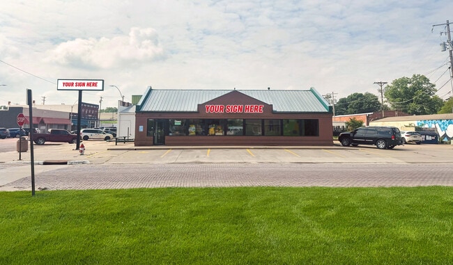
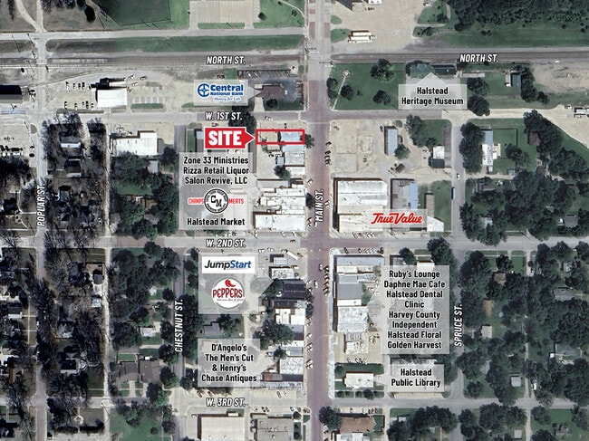
This Property Is For Sale
NEARBY LISTINGS FOR SALE OR LEASE
-
-
View all Halstead listings for sale on LoopNet.com
Property Detail
101 Main St
Wichita, KS
Halstead Original Town
077-35-0-40-06-001.00-0
HALSTEAD ORIGINAL TOWN, S35, T23, R02W, BEG NE COR BLK 3, S38, W140(S), N38, S140(S) TO POB; AKA PT OF LT S 1-4
Restaurantdrivein
Harvey
X
Kansas
20079C0169F
s
2024
0.12 AC
2025
Outlying Harvey County
030602
Wichita
1,792 SF
DEMOGRAPHICS near 101 Main St
1 Mile
3 Mile
5 Mile
2024 Total Population
2,080
2,480
2,933
2029 Population
2,053
2,444
2,883
Pop Growth 2024-2029
(1.30%)
(1.45%)
(1.70%)
Average Age
40
40
40
2024 Total Households
800
950
1,119
HH Growth 2024-2029
(1.38%)
(1.58%)
(1.70%)
Median Household Inc
$47,207
$48,293
$49,888
Avg Household Size
2.50
2.50
2.50
2024 Avg HH Vehicles
2.00
2.00
2.00
Median Home Value
$126,844
$134,352
$144,923
Median Year Built
1965
1966
1966
Nearby Places
Map Layers
Map Styles
 Street
 Aerial
- Restaurants
- Banks
- Shops
- Fitness
- Groceries
PUBLIC TRANSPORTATION
AIRPORT
Wichita Dwight D Eisenhower Ntl
DRIVE
WALK
Distance
Wichita Dwight D Eisenhower Ntl
55 min
40.9 mi
Nearby Properties
Address
Land Use
TOTAL SIZE
Lot Size
Zoning
Address
Land Use
TOTAL SIZE
Lot Size
Zoning
89,157 SF
46.35 AC
Address
Land Use
TOTAL SIZE
Lot Size
Zoning
87,943 SF
8 AC
Address
Land Use
TOTAL SIZE
Lot Size
Zoning
6,825 SF
10.08 AC
Address
Land Use
TOTAL SIZE
Lot Size
Zoning
4,651 SF
0.48 AC
Address
Land Use
TOTAL SIZE
Lot Size
Zoning
15,905 SF
0.52 AC
R1
Address
Land Use
TOTAL SIZE
Lot Size
Zoning
11,760 SF
0.26 AC
Address
Land Use
TOTAL SIZE
Lot Size
Zoning
9,660 SF
1.10 AC
R1
Address
Land Use
TOTAL SIZE
Lot Size
Zoning
7,402 SF
0.27 AC
Address
Land Use
TOTAL SIZE
Lot Size
Zoning
41,338 SF
14.30 AC
Address
Land Use
TOTAL SIZE
Lot Size
Zoning
5.99 AC
Address
Land Use
TOTAL SIZE
Lot Size
Zoning
14.40 AC
Address
Land Use
TOTAL SIZE
Lot Size
Zoning
6,454 SF
0.26 AC
R1
Address
Land Use
TOTAL SIZE
Lot Size
Zoning
3,562 SF
0.46 AC
Address
Land Use
TOTAL SIZE
Lot Size
Zoning
142.54 AC
Address
Land Use
TOTAL SIZE
Lot Size
Zoning
3,240 SF
0.26 AC
Address
Land Use
TOTAL SIZE
Lot Size
Zoning
75.69 AC
Address
Land Use
TOTAL SIZE
Lot Size
Zoning
2,806 SF
2.15 AC
Address
Land Use
TOTAL SIZE
Lot Size
Zoning
3,704 SF
1.40 AC
Address
Land Use
TOTAL SIZE
Lot Size
Zoning
3,540 SF
0.60 AC
Address
Land Use
TOTAL SIZE
Lot Size
Zoning
94,632 SF
15.62 AC
IND
Address
Land Use
TOTAL SIZE
Lot Size
Zoning
1,922 SF
93.86 AC
Address
Land Use
TOTAL SIZE
Lot Size
Zoning
69,559 SF
17.83 AC
IND
Address
Land Use
TOTAL SIZE
Lot Size
Zoning
3,344 SF
0.34 AC
R1
Address
Land Use
TOTAL SIZE
Lot Size
Zoning
44,876 SF
10.17 AC
IND
Address
Land Use
TOTAL SIZE
Lot Size
Zoning
1,066 SF
0.94 AC
IND
Address
Land Use
TOTAL SIZE
Lot Size
Zoning
1,862 SF
2.94 AC
R1
Address
Land Use
TOTAL SIZE
Lot Size
Zoning
21.52 AC
Address
Land Use
TOTAL SIZE
Lot Size
Zoning
47.14 AC
Address
Land Use
TOTAL SIZE
Lot Size
Zoning
14,400 SF
1.66 AC
Address
Land Use
TOTAL SIZE
Lot Size
Zoning
288 SF
0.96 AC
IND
The World's #1 Commercial Real Estate Marketplace
Connect with us
© 2026 CoStar Group
The information above has been obtained from sources believed reliable. While we do not doubt its accuracy we have not verified it and make no guarantee, warranty or representation about it. It is your responsibility to independently confirm its accuracy and completeness. Any projections, opinions, assumptions, or estimates used are for example only and do not represent the current or future performance of the property. The value of this transaction to you depends on tax and other factors which should be evaluated by your tax, financial, and legal advisors. You and your advisors should conduct a careful, independent investigation of the property to determine to your satisfaction the suitability of the property for your needs.