Property Record
101 Mills Gap Rd, Fletcher, NC 28732
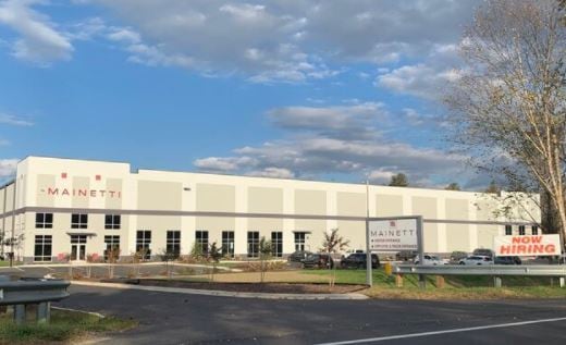

Property Detail
101 Mills Gap Rd
Asheville, NC
STEELCASE INC TRP/O A BMSLD-6342; INDUSTRIAL
1012291
Henderson
Industrialgeneral
North Carolina
1012291~M-
7979
AE The base floodplain where base flood elevations are provided. AE Zones are now used on new format FIRMs instead of A1-A30 Zones.
24.83 AC
2025
Henderson County
2025
Asheville
930502
NEARBY LISTINGS FOR SALE OR LEASE
DEMOGRAPHICS near 101 Mills Gap Rd
1 mile
3 mile
5 mile
2025 Total Population
2,363
23,844
51,604
2030 Population
2,472
24,465
52,967
Pop Growth 2025-2030
+ 4.61%
+ 2.60%
+ 2.64%
Average Age
41
42
43
2025 Total Households
1,010
9,890
21,729
HH Growth 2025-2030
+ 4.75%
+ 2.59%
+ 2.56%
Median Household Inc
$65,939
$75,715
$77,485
Avg Household Size
2.30
2.40
2.30
2025 Avg HH Vehicles
2.00
2.00
2.00
Median Home Value
$352,976
$361,461
$403,796
Median Year Built
2005
1995
1994
Nearby Places
Map Layers
Map Styles
 Street
 Aerial
Layers
 Traffic
 Biking
Places
Listings with unknown addresses are not visible on the map
- Restaurants
- Banks
- Shops
- Fitness
- Groceries
PUBLIC TRANSPORTATION
AIRPORT
Asheville Regional
Drive
Walk
Distance
Asheville Regional
10 min
5.1 mi
Freight Ports
North Charleston Terminal
Drive
Walk
Distance
North Charleston Terminal
276 min
244.9 mi
Nearby Properties
Address
Land Use
TOTAL SIZE
Lot Size
Zoning
Address
Land Use
TOTAL SIZE
Lot Size
Zoning
107,063 SF
567.34 AC
AI
Address
Land Use
TOTAL SIZE
Lot Size
Zoning
85,103 SF
11.69 AC
RES EXP
Address
Land Use
TOTAL SIZE
Lot Size
Zoning
207,701 SF
458.72 AC
R-3
Address
Land Use
TOTAL SIZE
Lot Size
Zoning
198,705 SF
32.46 AC
HB
Address
Land Use
TOTAL SIZE
Lot Size
Zoning
73,420 SF
10.24 AC
RM16
Address
Land Use
TOTAL SIZE
Lot Size
Zoning
481,731 SF
86.32 AC
1009658~I
Address
Land Use
TOTAL SIZE
Lot Size
Zoning
3,466 SF
11.32 AC
10000832~M
Address
Land Use
TOTAL SIZE
Lot Size
Zoning
4,839 SF
9.46 AC
10002512~C
Address
Land Use
TOTAL SIZE
Lot Size
Zoning
92,772 SF
12.30 AC
R-2
Address
Land Use
TOTAL SIZE
Lot Size
Zoning
899,676 SF
46.99 AC
1006235~M-
Address
Land Use
TOTAL SIZE
Lot Size
Zoning
43,882 SF
9.71 AC
1016337~C1
Address
Land Use
TOTAL SIZE
Lot Size
Zoning
87,220 SF
39.11 AC
PS
Address
Land Use
TOTAL SIZE
Lot Size
Zoning
107,698 SF
25.53 AC
PS
Address
Land Use
TOTAL SIZE
Lot Size
Zoning
208,715 SF
33.50 AC
CI
Address
Land Use
TOTAL SIZE
Lot Size
Zoning
41,104 SF
5.45 AC
CR
Address
Land Use
TOTAL SIZE
Lot Size
Zoning
76,255 SF
10.55 AC
EMP
Address
Land Use
TOTAL SIZE
Lot Size
Zoning
415,861 SF
59.02 AC
9927651~M-
Address
Land Use
TOTAL SIZE
Lot Size
Zoning
13,525 SF
1.84 AC
LODG EXP
Address
Land Use
TOTAL SIZE
Lot Size
Zoning
15,493 SF
2.01 AC
EMP
Address
Land Use
TOTAL SIZE
Lot Size
Zoning
28,183 SF
5.88 AC
10010086~C
Address
Land Use
TOTAL SIZE
Lot Size
Zoning
82,096 SF
19.67 AC
1015839~R1
Address
Land Use
TOTAL SIZE
Lot Size
Zoning
14,024 SF
2 AC
HB
Address
Land Use
TOTAL SIZE
Lot Size
Zoning
51,090 SF
5.18 AC
1007612~C-
Address
Land Use
TOTAL SIZE
Lot Size
Zoning
43,030 SF
5.15 AC
1016338~C1
Address
Land Use
TOTAL SIZE
Lot Size
Zoning
71,973 SF
6.71 AC
HB
Address
Land Use
TOTAL SIZE
Lot Size
Zoning
404,414 SF
27.75 AC
IND
Address
Land Use
TOTAL SIZE
Lot Size
Zoning
57,827 SF
1.68 AC
1017417~C-
Address
Land Use
TOTAL SIZE
Lot Size
Zoning
123,362 SF
11.70 AC
HB
Address
Land Use
TOTAL SIZE
Lot Size
Zoning
355,552 SF
40.75 AC
EMP
The World's #1 Commercial Real Estate Marketplace
Connect with us
© 2026 CoStar Group
The information above has been obtained from sources believed reliable. While we do not doubt its accuracy we have not verified it and make no guarantee, warranty or representation about it. It is your responsibility to independently confirm its accuracy and completeness. Any projections, opinions, assumptions, or estimates used are for example only and do not represent the current or future performance of the property. The value of this transaction to you depends on tax and other factors which should be evaluated by your tax, financial, and legal advisors. You and your advisors should conduct a careful, independent investigation of the property to determine to your satisfaction the suitability of the property for your needs.