Property Record
101 Moulton St W, Decatur, AL 35601


NEARBY LISTINGS FOR SALE OR LEASE
-
-
View all Decatur listings for sale on LoopNet.com
Property Detail
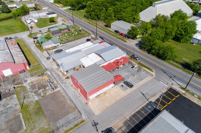
101 Moulton St W
Decatur, AL
Dli&F Add 2
03-04-19-1-006-001.000
BEG NW COR OF LOT 6 BLK 2 DLI&F ADD 2 SEC 19 T5S R4W TH E 60' TO 1ST AVE SW SO 130' W 60' N 130' TO POB
Autorepair
Morgan
AE
Alabama
01083C0326F
6
2025
0.18 AC
2024
Downtown Decatur
000700
Other Market Areas
2,500 SF
DEMOGRAPHICS near 101 Moulton St W
1 Mile
3 Mile
5 Mile
2024 Total Population
8,897
37,249
55,980
2029 Population
9,080
37,608
56,305
Pop Growth 2024-2029
+ 2.06%
+ 0.96%
+ 0.58%
Average Age
40
39
40
2024 Total Households
3,300
14,809
22,779
HH Growth 2024-2029
+ 2.27%
+ 0.99%
+ 0.58%
Median Household Inc
$33,725
$44,914
$48,386
Avg Household Size
2.20
2.30
2.30
2024 Avg HH Vehicles
2.00
2.00
2.00
Median Home Value
$110,363
$127,480
$151,929
Median Year Built
1957
1969
1976
Nearby Places
Map Layers
Map Styles
 Street
 Aerial
- Restaurants
- Banks
- Shops
- Fitness
- Groceries
PUBLIC TRANSPORTATION
AIRPORT
Huntsville International-Carl T Jones Field
DRIVE
WALK
Distance
Huntsville International-Carl T Jones Field
24 min
16.3 mi
Freight Ports
Port of Mobile
DRIVE
WALK
Distance
Port of Mobile
372 min
336.6 mi
SALE & LEASE HISTORY
LISTING DATE
SALE/LEASE

Sep 22, 2023
For Sale
Apr 21, 2021
For Sale
Nearby Properties
Address
Land Use
TOTAL SIZE
Lot Size
Zoning
Address
Land Use
TOTAL SIZE
Lot Size
Zoning
176,476 SF
Address
Land Use
TOTAL SIZE
Lot Size
Zoning
121,551 SF
Address
Land Use
TOTAL SIZE
Lot Size
Zoning
90,249 SF
8 AC
Address
Land Use
TOTAL SIZE
Lot Size
Zoning
103,569 SF
6.69 AC
Address
Land Use
TOTAL SIZE
Lot Size
Zoning
7,812 SF
162 AC
Address
Land Use
TOTAL SIZE
Lot Size
Zoning
258,250 SF
55 AC
Address
Land Use
TOTAL SIZE
Lot Size
Zoning
15,331 SF
87 AC
Address
Land Use
TOTAL SIZE
Lot Size
Zoning
133,056 SF
6.29 AC
Address
Land Use
TOTAL SIZE
Lot Size
Zoning
132,156 SF
1.69 AC
Address
Land Use
TOTAL SIZE
Lot Size
Zoning
35,727 SF
10 AC
Address
Land Use
TOTAL SIZE
Lot Size
Zoning
77,430 SF
19 AC
Address
Land Use
TOTAL SIZE
Lot Size
Zoning
48,364 SF
1.80 AC
Address
Land Use
TOTAL SIZE
Lot Size
Zoning
40,212 SF
1.21 AC
Address
Land Use
TOTAL SIZE
Lot Size
Zoning
54,544 SF
6.53 AC
Address
Land Use
TOTAL SIZE
Lot Size
Zoning
51,958 SF
14 AC
Address
Land Use
TOTAL SIZE
Lot Size
Zoning
106,165 SF
0.80 AC
Address
Land Use
TOTAL SIZE
Lot Size
Zoning
100,632 SF
20 AC
Address
Land Use
TOTAL SIZE
Lot Size
Zoning
2,010 SF
20 AC
Address
Land Use
TOTAL SIZE
Lot Size
Zoning
377,685 SF
17 AC
Address
Land Use
TOTAL SIZE
Lot Size
Zoning
81,682 SF
13 AC
Address
Land Use
TOTAL SIZE
Lot Size
Zoning
135,440 SF
6.76 AC
Address
Land Use
TOTAL SIZE
Lot Size
Zoning
220,128 SF
34 AC
Address
Land Use
TOTAL SIZE
Lot Size
Zoning
145,413 SF
2.30 AC
Address
Land Use
TOTAL SIZE
Lot Size
Zoning
2,546 SF
9.30 AC
Address
Land Use
TOTAL SIZE
Lot Size
Zoning
64,449 SF
12 AC
Address
Land Use
TOTAL SIZE
Lot Size
Zoning
4,865 SF
22 AC
Address
Land Use
TOTAL SIZE
Lot Size
Zoning
32,821 SF
1.68 AC
Address
Land Use
TOTAL SIZE
Lot Size
Zoning
49,384 SF
1.07 AC
Address
Land Use
TOTAL SIZE
Lot Size
Zoning
6.50 AC
Address
Land Use
TOTAL SIZE
Lot Size
Zoning
19,494 SF
3.30 AC
The World's #1 Commercial Real Estate Marketplace
Connect with us
© 2026 CoStar Group
The information above has been obtained from sources believed reliable. While we do not doubt its accuracy we have not verified it and make no guarantee, warranty or representation about it. It is your responsibility to independently confirm its accuracy and completeness. Any projections, opinions, assumptions, or estimates used are for example only and do not represent the current or future performance of the property. The value of this transaction to you depends on tax and other factors which should be evaluated by your tax, financial, and legal advisors. You and your advisors should conduct a careful, independent investigation of the property to determine to your satisfaction the suitability of the property for your needs.