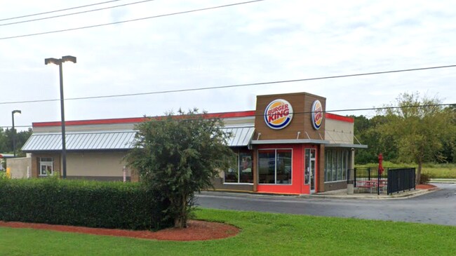
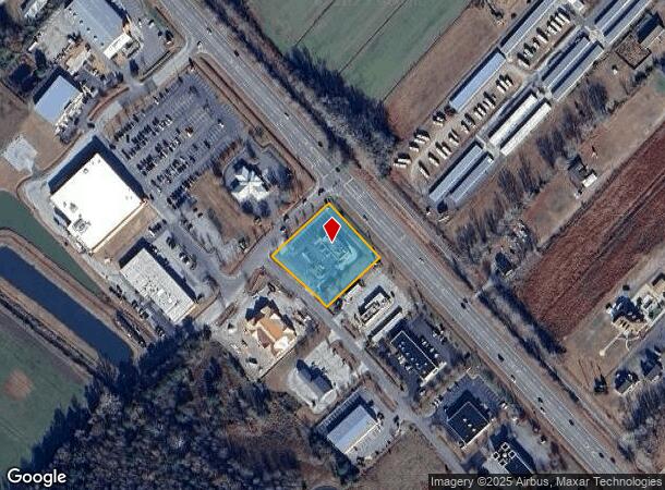
Property Record
101 Moyock Commons Dr, Moyock, NC 27958

NEARBY LISTINGS FOR SALE OR LEASE
-
-
View all Moyock listings for sale on LoopNet.com
Property Detail
101 Moyock Commons Dr
Virginia Beach-Norfolk-Newport News, VA-NC
Currituck Commercial Center
015B-000-0001-0000
CURRITUCK COMM CENTER TRACT 1
Restaurantdrivein
Currituck
X
North Carolina
3721803100K
1
2025
1.07 AC
2025
Currituck County
110202
Hampton Roads
2,900 SF
DEMOGRAPHICS near 101 Moyock Commons Dr
1 Mile
3 Mile
5 Mile
2024 Total Population
1,767
8,241
12,460
2029 Population
2,246
10,434
15,386
Pop Growth 2024-2029
+ 27.11%
+ 26.61%
+ 23.48%
Average Age
38
38
39
2024 Total Households
594
2,781
3,971
HH Growth 2024-2029
+ 27.10%
+ 26.65%
+ 25.13%
Median Household Inc
$100,421
$101,933
$100,520
Avg Household Size
2.90
2.90
2.90
2024 Avg HH Vehicles
3.00
3.00
3.00
Median Home Value
$322,839
$322,144
$329,738
Median Year Built
2005
2004
2003
Nearby Places
Map Layers
Map Styles
 Street
 Aerial
- Restaurants
- Banks
- Shops
- Fitness
- Groceries
PUBLIC TRANSPORTATION
AIRPORT
Norfolk International
DRIVE
WALK
Distance
Norfolk International
47 min
30.8 mi
Freight Ports
Virginia Port Authority - Portsmouth
DRIVE
WALK
Distance
Virginia Port Authority - Portsmouth
45 min
29.9 mi
SALE & LEASE HISTORY
LISTING DATE
SALE/LEASE

Sep 26, 2024
For Sale
Dec 04, 2024
For Sale
Nearby Properties
Address
Land Use
TOTAL SIZE
Lot Size
Zoning
Address
Land Use
TOTAL SIZE
Lot Size
Zoning
89,104 SF
40 AC
AG
Address
Land Use
TOTAL SIZE
Lot Size
Zoning
31,599 SF
6 AC
GB
Address
Land Use
TOTAL SIZE
Lot Size
Zoning
59,355 SF
20.44 AC
GB
Address
Land Use
TOTAL SIZE
Lot Size
Zoning
19,152 SF
3.60 AC
Address
Land Use
TOTAL SIZE
Lot Size
Zoning
1,568 SF
160.51 AC
Address
Land Use
TOTAL SIZE
Lot Size
Zoning
37,903 SF
4.40 AC
GB
Address
Land Use
TOTAL SIZE
Lot Size
Zoning
30,330 SF
6.99 AC
GB
Address
Land Use
TOTAL SIZE
Lot Size
Zoning
349.61 AC
Address
Land Use
TOTAL SIZE
Lot Size
Zoning
299.50 AC
AG
Address
Land Use
TOTAL SIZE
Lot Size
Zoning
18,820 SF
2.41 AC
GB
Address
Land Use
TOTAL SIZE
Lot Size
Zoning
10,642 SF
12.15 AC
GB
Address
Land Use
TOTAL SIZE
Lot Size
Zoning
302.50 AC
AG
Address
Land Use
TOTAL SIZE
Lot Size
Zoning
19,680 SF
13.59 AC
B1: NEIGHB
Address
Land Use
TOTAL SIZE
Lot Size
Zoning
12,850 SF
1.05 AC
GB
Address
Land Use
TOTAL SIZE
Lot Size
Zoning
5,017 SF
10.78 AC
B1: NEIGHB
Address
Land Use
TOTAL SIZE
Lot Size
Zoning
123.86 AC
PD-R
Address
Land Use
TOTAL SIZE
Lot Size
Zoning
18,800 SF
3.47 AC
GB
Address
Land Use
TOTAL SIZE
Lot Size
Zoning
4,905 SF
2.95 AC
Address
Land Use
TOTAL SIZE
Lot Size
Zoning
296.34 AC
AG
Address
Land Use
TOTAL SIZE
Lot Size
Zoning
17,015 SF
2.50 AC
GB
Address
Land Use
TOTAL SIZE
Lot Size
Zoning
14,714 SF
1.76 AC
GB
Address
Land Use
TOTAL SIZE
Lot Size
Zoning
24.12 AC
GB
Address
Land Use
TOTAL SIZE
Lot Size
Zoning
12,716 SF
3.07 AC
GB
Address
Land Use
TOTAL SIZE
Lot Size
Zoning
10,170 SF
1.49 AC
GB
Address
Land Use
TOTAL SIZE
Lot Size
Zoning
18,000 SF
2.03 AC
GB
Address
Land Use
TOTAL SIZE
Lot Size
Zoning
10,586 SF
3.08 AC
GB
Address
Land Use
TOTAL SIZE
Lot Size
Zoning
219 AC
AG
Address
Land Use
TOTAL SIZE
Lot Size
Zoning
3,780 SF
1.51 AC
GB
Address
Land Use
TOTAL SIZE
Lot Size
Zoning
49.12 AC
LI
The World's #1 Commercial Real Estate Marketplace
Connect with us
© 2026 CoStar Group
The information above has been obtained from sources believed reliable. While we do not doubt its accuracy we have not verified it and make no guarantee, warranty or representation about it. It is your responsibility to independently confirm its accuracy and completeness. Any projections, opinions, assumptions, or estimates used are for example only and do not represent the current or future performance of the property. The value of this transaction to you depends on tax and other factors which should be evaluated by your tax, financial, and legal advisors. You and your advisors should conduct a careful, independent investigation of the property to determine to your satisfaction the suitability of the property for your needs.