Property Record
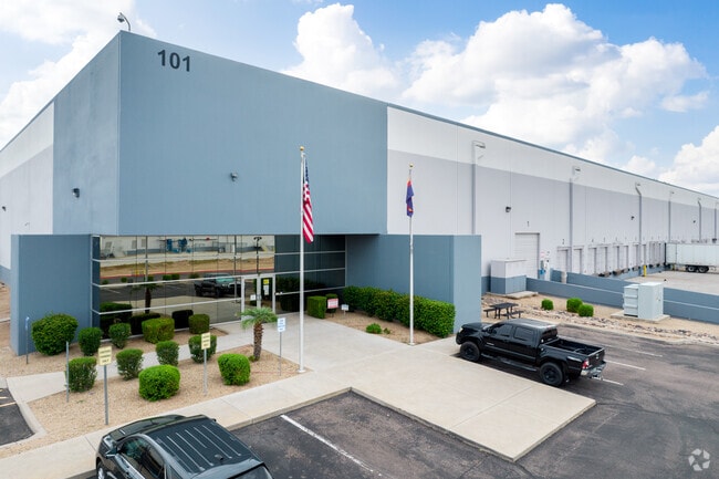
101 N 103Rd Ave, Tolleson, AZ 85353


Current Lease Availabilities
NEARBY LISTINGS FOR SALE OR LEASE
Property Detail
101 N 103Rd Ave
101-03-004H
TH POR N2 SEC 8 DAF COM AT N4 COR SD SEC 8 TH S 608.51F TH E 312.43F TO POB TH CONT E 1146.41F TH S 579.78F TH W 1146.41F TO PT TH N 579.78F TO POB & EX P/F 99-0035861
Warehouse
Maricopa
X
Arizona
04013C2160M
15.22 AC
2025
Tolleson
2025
Phoenix
083000
Phoenix-Mesa-Scottsdale, AZ
276,950 SF
DEMOGRAPHICS near 101 N 103Rd Ave
1 Mile
3 Mile
5 Mile
2024 Total Population
3,516
109,955
280,782
2029 Population
3,850
118,700
303,818
Pop Growth 2024-2029
+ 9.50%
+ 7.95%
+ 8.20%
Average Age
34
32
33
2024 Total Households
1,017
31,004
80,767
HH Growth 2024-2029
+ 9.64%
+ 8.05%
+ 8.34%
Median Household Inc
$52,363
$77,726
$69,061
Avg Household Size
3.40
3.40
3.40
2024 Avg HH Vehicles
2.00
2.00
2.00
Median Home Value
$258,904
$297,902
$285,665
Median Year Built
2000
2003
2000
Nearby Places
Map Layers
Map Styles
 Street
 Aerial
- Restaurants
- Banks
- Shops
- Fitness
- Groceries
PUBLIC TRANSPORTATION
AIRPORT
Phoenix Sky Harbor International
DRIVE
WALK
Distance
Phoenix Sky Harbor International
28 min
19.1 mi
Nearby Properties
Address
Land Use
TOTAL SIZE
Lot Size
Zoning
Address
Land Use
TOTAL SIZE
Lot Size
Zoning
12.04 AC
Address
Land Use
TOTAL SIZE
Lot Size
Zoning
12.80 AC
Address
Land Use
TOTAL SIZE
Lot Size
Zoning
206.08 AC
PAD
Address
Land Use
TOTAL SIZE
Lot Size
Zoning
896,916 SF
25.91 AC
C-C
Address
Land Use
TOTAL SIZE
Lot Size
Zoning
Address
Land Use
TOTAL SIZE
Lot Size
Zoning
Address
Land Use
TOTAL SIZE
Lot Size
Zoning
889,089 SF
83.11 AC
I-1
Address
Land Use
TOTAL SIZE
Lot Size
Zoning
134.65 AC
S1
Address
Land Use
TOTAL SIZE
Lot Size
Zoning
1,100,500 SF
57.61 AC
PUD
Address
Land Use
TOTAL SIZE
Lot Size
Zoning
177,052 SF
2.69 AC
THEBLVDD
Address
Land Use
TOTAL SIZE
Lot Size
Zoning
728,550 SF
41.98 AC
Address
Land Use
TOTAL SIZE
Lot Size
Zoning
287,294 SF
67.46 AC
PAD
Address
Land Use
TOTAL SIZE
Lot Size
Zoning
301,329 SF
50.60 AC
AG
Address
Land Use
TOTAL SIZE
Lot Size
Zoning
763,410 SF
45.50 AC
Address
Land Use
TOTAL SIZE
Lot Size
Zoning
697,149 SF
37.60 AC
CP/GCP
Address
Land Use
TOTAL SIZE
Lot Size
Zoning
750,037 SF
49.40 AC
I1
Address
Land Use
TOTAL SIZE
Lot Size
Zoning
587,843 SF
20.49 AC
PAD
Address
Land Use
TOTAL SIZE
Lot Size
Zoning
369,413 SF
16.39 AC
THEBLVDD
Address
Land Use
TOTAL SIZE
Lot Size
Zoning
466,868 SF
45.99 AC
I-1
Address
Land Use
TOTAL SIZE
Lot Size
Zoning
432,022 SF
19.33 AC
PAD
Address
Land Use
TOTAL SIZE
Lot Size
Zoning
797,310 SF
36.82 AC
I-1
Address
Land Use
TOTAL SIZE
Lot Size
Zoning
628,480 SF
34.45 AC
PAD
Address
Land Use
TOTAL SIZE
Lot Size
Zoning
660,980 SF
40.15 AC
Address
Land Use
TOTAL SIZE
Lot Size
Zoning
397,132 SF
27.52 AC
I1
Address
Land Use
TOTAL SIZE
Lot Size
Zoning
487,424 SF
30.05 AC
CPGCP
Address
Land Use
TOTAL SIZE
Lot Size
Zoning
370,522 SF
9.45 AC
Address
Land Use
TOTAL SIZE
Lot Size
Zoning
409,088 SF
21.34 AC
PAD
Address
Land Use
TOTAL SIZE
Lot Size
Zoning
630,285 SF
36.02 AC
R-43AG
Address
Land Use
TOTAL SIZE
Lot Size
Zoning
13.45 AC
The World's #1 Commercial Real Estate Marketplace
Connect with us
© 2025 CoStar Group
The information above has been obtained from sources believed reliable. While we do not doubt its accuracy we have not verified it and make no guarantee, warranty or representation about it. It is your responsibility to independently confirm its accuracy and completeness. Any projections, opinions, assumptions, or estimates used are for example only and do not represent the current or future performance of the property. The value of this transaction to you depends on tax and other factors which should be evaluated by your tax, financial, and legal advisors. You and your advisors should conduct a careful, independent investigation of the property to determine to your satisfaction the suitability of the property for your needs.