Property Record
101 N 2Nd St, Evanston, WY 82930
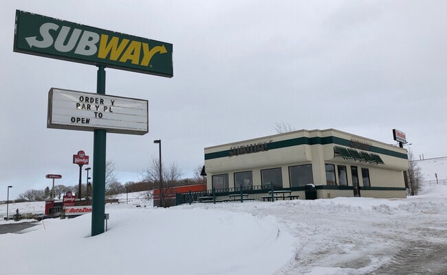


Property Detail
101 N 2Nd St
Evanston, WY-UT
CROSSROADS ADD BLK 1 LT 5A
R0004976
Uinta
Restaurantdrivein
Wyoming
B and X Area of moderate flood hazard, usually the area between the limits of the 100-year and 500-year floods.
5a
2024
0.90 AC
2025
I-80 Corridor/Cheyenne
975401
Other Market Areas
1,390 SF
NEARBY LISTINGS FOR SALE OR LEASE
DEMOGRAPHICS near 101 N 2Nd St
1 mile
3 mile
5 mile
2025 Total Population
5,120
13,048
13,934
2030 Population
5,190
13,177
14,165
Pop Growth 2025-2030
+ 1.37%
+ 0.99%
+ 1.66%
Average Age
38
38
38
2025 Total Households
2,036
4,995
5,347
HH Growth 2025-2030
+ 1.33%
+ 0.90%
+ 1.59%
Median Household Inc
$69,827
$76,049
$76,755
Avg Household Size
2.40
2.50
2.50
2025 Avg HH Vehicles
2.00
2.00
2.00
Median Home Value
$242,443
$257,134
$262,302
Median Year Built
1978
1982
1983
Nearby Places
Map Layers
Map Styles
 Street
 Aerial
Transit
 Traffic
 Biking
Places
Listings with unknown addresses are not visible on the map
- Restaurants
- Banks
- Shops
- Fitness
- Groceries
SALE & LEASE HISTORY
LISTING DATE
SALE/LEASE

Oct 21, 2022
For Sale
Nov 17, 2020
For Sale
Jan 27, 2020
For Lease
Nearby Properties
Address
Land Use
TOTAL SIZE
Lot Size
Zoning
Address
Land Use
TOTAL SIZE
Lot Size
Zoning
154.18 AC
Address
Land Use
TOTAL SIZE
Lot Size
Zoning
165,417 SF
16.36 AC
Address
Land Use
TOTAL SIZE
Lot Size
Zoning
79,438 SF
5 AC
Address
Land Use
TOTAL SIZE
Lot Size
Zoning
118,542 SF
5.91 AC
Address
Land Use
TOTAL SIZE
Lot Size
Zoning
69,131 SF
7.74 AC
Address
Land Use
TOTAL SIZE
Lot Size
Zoning
58,721 SF
7.13 AC
Address
Land Use
TOTAL SIZE
Lot Size
Zoning
98,088 SF
3.70 AC
Address
Land Use
TOTAL SIZE
Lot Size
Zoning
1,328 SF
8.69 AC
Address
Land Use
TOTAL SIZE
Lot Size
Zoning
62,682 SF
11.13 AC
Address
Land Use
TOTAL SIZE
Lot Size
Zoning
33,948 SF
1.51 AC
Address
Land Use
TOTAL SIZE
Lot Size
Zoning
21,463 SF
0.61 AC
Address
Land Use
TOTAL SIZE
Lot Size
Zoning
36,480 SF
0.28 AC
Address
Land Use
TOTAL SIZE
Lot Size
Zoning
51,569 SF
3.80 AC
Address
Land Use
TOTAL SIZE
Lot Size
Zoning
61,180 SF
4.05 AC
Address
Land Use
TOTAL SIZE
Lot Size
Zoning
62,370 SF
2.72 AC
Address
Land Use
TOTAL SIZE
Lot Size
Zoning
18,737 SF
3.33 AC
Address
Land Use
TOTAL SIZE
Lot Size
Zoning
69,146 SF
6.54 AC
Address
Land Use
TOTAL SIZE
Lot Size
Zoning
32,820 SF
0.26 AC
Address
Land Use
TOTAL SIZE
Lot Size
Zoning
47,260 SF
2.06 AC
Address
Land Use
TOTAL SIZE
Lot Size
Zoning
27,880 SF
5 AC
Address
Land Use
TOTAL SIZE
Lot Size
Zoning
7,762 SF
0.58 AC
Address
Land Use
TOTAL SIZE
Lot Size
Zoning
99.74 AC
Address
Land Use
TOTAL SIZE
Lot Size
Zoning
36,552 SF
4.40 AC
Address
Land Use
TOTAL SIZE
Lot Size
Zoning
27,735 SF
4.15 AC
Address
Land Use
TOTAL SIZE
Lot Size
Zoning
28,966 SF
1.76 AC
Address
Land Use
TOTAL SIZE
Lot Size
Zoning
50,200 SF
2.92 AC
Address
Land Use
TOTAL SIZE
Lot Size
Zoning
25,886 SF
1.52 AC
Address
Land Use
TOTAL SIZE
Lot Size
Zoning
47,094 SF
4.04 AC
Address
Land Use
TOTAL SIZE
Lot Size
Zoning
29,277 SF
3.81 AC
Address
Land Use
TOTAL SIZE
Lot Size
Zoning
7,000 SF
0.75 AC
The World's #1 Commercial Real Estate Marketplace
Connect with us
© 2026 CoStar Group
The information above has been obtained from sources believed reliable. While we do not doubt its accuracy we have not verified it and make no guarantee, warranty or representation about it. It is your responsibility to independently confirm its accuracy and completeness. Any projections, opinions, assumptions, or estimates used are for example only and do not represent the current or future performance of the property. The value of this transaction to you depends on tax and other factors which should be evaluated by your tax, financial, and legal advisors. You and your advisors should conduct a careful, independent investigation of the property to determine to your satisfaction the suitability of the property for your needs.