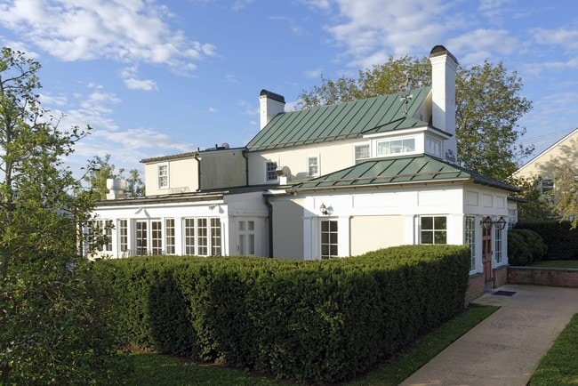
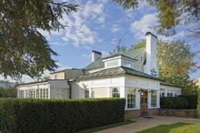
Property Record
101 N Madison St, Middleburg, VA 20117

NEARBY LISTINGS FOR SALE OR LEASE
-
-
View all Middleburg listings for lease on LoopNet.com
Property Detail
101 N Madison St
538-28-4086
Middleburg
Publichealthcarefacility
MIDDLEBURG ELEMENTARY 8N--402
X
Loudoun
51061C0125D
Virginia
0
3.72 AC
2025
Leesburg/West Loudoun
610900
Washington, DC
22,107 SF
Washington-Arlington-Alexandria, DC-VA-MD-WV
DEMOGRAPHICS near 101 N Madison St
1 Mile
3 Mile
5 Mile
2024 Total Population
636
1,526
3,464
2029 Population
657
1,590
3,649
Pop Growth 2024-2029
+ 3.30%
+ 4.19%
+ 5.34%
Average Age
49
48
47
2024 Total Households
304
693
1,476
HH Growth 2024-2029
+ 3.29%
+ 4.04%
+ 5.15%
Median Household Inc
$107,738
$106,111
$107,913
Avg Household Size
2.10
2.20
2.30
2024 Avg HH Vehicles
2.00
2.00
2.00
Median Home Value
$824,467
$888,888
$901,863
Median Year Built
1965
1967
1972
Nearby Places
Map Layers
Map Styles
 Street
 Aerial
- Restaurants
- Banks
- Shops
- Fitness
- Groceries
PUBLIC TRANSPORTATION
AIRPORT
Washington Dulles International
DRIVE
WALK
Distance
Washington Dulles International
42 min
22.0 mi
Freight Ports
Port of Baltimore
DRIVE
WALK
Distance
Port of Baltimore
115 min
80.0 mi
SALE & LEASE HISTORY
LISTING DATE
SALE/LEASE

Dec 08, 2016
For Lease
Nearby Properties
Address
Land Use
TOTAL SIZE
Lot Size
Zoning
Address
Land Use
TOTAL SIZE
Lot Size
Zoning
224,000 SF
272.13 AC
MB:AC
Address
Land Use
TOTAL SIZE
Lot Size
Zoning
391,055 SF
495.44 AC
AR2
Address
Land Use
TOTAL SIZE
Lot Size
Zoning
14,988 SF
4.70 AC
MB:C1
Address
Land Use
TOTAL SIZE
Lot Size
Zoning
61,488 SF
89.39 AC
AR2
Address
Land Use
TOTAL SIZE
Lot Size
Zoning
3,240 SF
99.89 AC
AR2
Address
Land Use
TOTAL SIZE
Lot Size
Zoning
34,334 SF
22.92 AC
MB:C3
Address
Land Use
TOTAL SIZE
Lot Size
Zoning
20,401 SF
1.49 AC
MB:C1
Address
Land Use
TOTAL SIZE
Lot Size
Zoning
24,682 SF
2.49 AC
MB:R2
Address
Land Use
TOTAL SIZE
Lot Size
Zoning
13,517 SF
1.36 AC
MB:MUV
Address
Land Use
TOTAL SIZE
Lot Size
Zoning
25,200 SF
10 AC
AGRICULTUR
Address
Land Use
TOTAL SIZE
Lot Size
Zoning
26,354 SF
1.88 AC
MB:C2
Address
Land Use
TOTAL SIZE
Lot Size
Zoning
17,302 SF
0.60 AC
MB:C2
Address
Land Use
TOTAL SIZE
Lot Size
Zoning
4,352 SF
40.22 AC
MB:C3
Address
Land Use
TOTAL SIZE
Lot Size
Zoning
19,858 SF
0.71 AC
MB:C2
Address
Land Use
TOTAL SIZE
Lot Size
Zoning
960 SF
400.90 AC
AGRICULTUR
Address
Land Use
TOTAL SIZE
Lot Size
Zoning
10,320 SF
0.81 AC
MB:C1
Address
Land Use
TOTAL SIZE
Lot Size
Zoning
5,018 SF
128.56 AC
AR2
Address
Land Use
TOTAL SIZE
Lot Size
Zoning
18,963 SF
0.36 AC
MB:C1
Address
Land Use
TOTAL SIZE
Lot Size
Zoning
12,254 SF
0.45 AC
MB:C2
Address
Land Use
TOTAL SIZE
Lot Size
Zoning
12,159 SF
0.85 AC
MB:C2
Address
Land Use
TOTAL SIZE
Lot Size
Zoning
9,705 SF
0.57 AC
MB:C2
Address
Land Use
TOTAL SIZE
Lot Size
Zoning
2,082 SF
46.59 AC
AR2
Address
Land Use
TOTAL SIZE
Lot Size
Zoning
10,885 SF
0.84 AC
MB:R3
Address
Land Use
TOTAL SIZE
Lot Size
Zoning
17,920 SF
0.50 AC
MB:C2
Address
Land Use
TOTAL SIZE
Lot Size
Zoning
8,648 SF
0.50 AC
MB:C1
Address
Land Use
TOTAL SIZE
Lot Size
Zoning
11,190 SF
1.43 AC
MB:R2
Address
Land Use
TOTAL SIZE
Lot Size
Zoning
2,600 SF
0.89 AC
MB:R3
Address
Land Use
TOTAL SIZE
Lot Size
Zoning
112.20 AC
AR2
Address
Land Use
TOTAL SIZE
Lot Size
Zoning
13,836 SF
0.21 AC
MB:C2
The World's #1 Commercial Real Estate Marketplace
Connect with us
© 2025 CoStar Group
The information above has been obtained from sources believed reliable. While we do not doubt its accuracy we have not verified it and make no guarantee, warranty or representation about it. It is your responsibility to independently confirm its accuracy and completeness. Any projections, opinions, assumptions, or estimates used are for example only and do not represent the current or future performance of the property. The value of this transaction to you depends on tax and other factors which should be evaluated by your tax, financial, and legal advisors. You and your advisors should conduct a careful, independent investigation of the property to determine to your satisfaction the suitability of the property for your needs.