Property Record
101 N Main St, Carrollton, MO 64633

Save to a Folder
{{folder.Name}}
{{folder.ListingIds.length}} Properties
{{folder.ListingIds.length}} Property
Create a New Folder
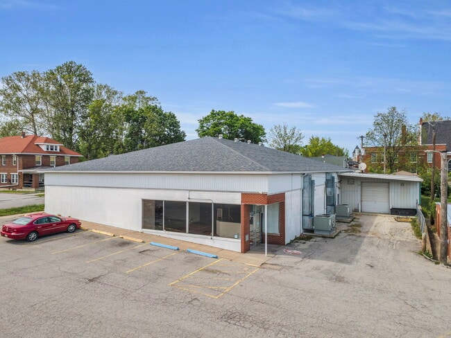
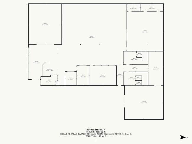
Property Detail
101 N Main St
14-9.0-32-4-03-016
ORIGINAL TOWN-CARR; ALL LOTS 2 THRU 7;BLK 3;S5'OF LOT5;BLK46
Supermarket
CARROLL
B and X Area of moderate flood hazard, usually the area between the limits of the 100-year and 500-year floods.
Missouri
2024
2-7
2025
0.94 AC
960300
Missouri North Area
7,930 SF
Other Market Areas
NEARBY LISTINGS FOR SALE OR LEASE
DEMOGRAPHICS near 101 N Main St
1 mile
3 mile
5 mile
2025 Total Population
3,292
4,150
4,445
2030 Population
3,363
4,218
4,504
Pop Growth 2025-2030
+ 2.16%
+ 1.64%
+ 1.33%
Average Age
43
43
43
2025 Total Households
1,405
1,755
1,878
HH Growth 2025-2030
+ 2.21%
+ 1.71%
+ 1.33%
Median Household Inc
$59,705
$58,915
$59,308
Avg Household Size
2.20
2.20
2.30
2025 Avg HH Vehicles
2.00
2.00
2.00
Median Home Value
$127,987
$130,657
$130,663
Median Year Built
1962
1963
1963
Nearby Places
Map Layers
Map Styles
 Street
 Aerial
Layers
 Traffic
 Biking
Places
Listings with unknown addresses are not visible on the map
- Restaurants
- Banks
- Shops
- Fitness
- Groceries
SALE & LEASE HISTORY
LISTING DATE
SALE/LEASE

May 14, 2025
For Sale
Nearby Properties
Address
Land Use
TOTAL SIZE
Lot Size
Zoning
Address
Land Use
TOTAL SIZE
Lot Size
Zoning
Address
Land Use
TOTAL SIZE
Lot Size
Zoning
2.85 AC
Address
Land Use
TOTAL SIZE
Lot Size
Zoning
18,050 SF
2.11 AC
Address
Land Use
TOTAL SIZE
Lot Size
Zoning
46.77 AC
Address
Land Use
TOTAL SIZE
Lot Size
Zoning
720 SF
4.63 AC
Address
Land Use
TOTAL SIZE
Lot Size
Zoning
12.32 AC
Address
Land Use
TOTAL SIZE
Lot Size
Zoning
0.65 AC
Address
Land Use
TOTAL SIZE
Lot Size
Zoning
2.54 AC
Address
Land Use
TOTAL SIZE
Lot Size
Zoning
26,820 SF
3.60 AC
Address
Land Use
TOTAL SIZE
Lot Size
Zoning
Address
Land Use
TOTAL SIZE
Lot Size
Zoning
3.10 AC
Address
Land Use
TOTAL SIZE
Lot Size
Zoning
Address
Land Use
TOTAL SIZE
Lot Size
Zoning
5.18 AC
Address
Land Use
TOTAL SIZE
Lot Size
Zoning
3,309 SF
0.40 AC
Address
Land Use
TOTAL SIZE
Lot Size
Zoning
9,301 SF
1.42 AC
Address
Land Use
TOTAL SIZE
Lot Size
Zoning
2,501 SF
0.57 AC
Address
Land Use
TOTAL SIZE
Lot Size
Zoning
22.90 AC
Address
Land Use
TOTAL SIZE
Lot Size
Zoning
0.28 AC
Address
Land Use
TOTAL SIZE
Lot Size
Zoning
4,300 SF
1.76 AC
Address
Land Use
TOTAL SIZE
Lot Size
Zoning
65.90 AC
Address
Land Use
TOTAL SIZE
Lot Size
Zoning
0.46 AC
Address
Land Use
TOTAL SIZE
Lot Size
Zoning
6.30 AC
Address
Land Use
TOTAL SIZE
Lot Size
Zoning
9.60 AC
Address
Land Use
TOTAL SIZE
Lot Size
Zoning
80 AC
Address
Land Use
TOTAL SIZE
Lot Size
Zoning
0.86 AC
The World's #1 Commercial Real Estate Marketplace
Connect with us
© 2026 CoStar Group
The information above has been obtained from sources believed reliable. While we do not doubt its accuracy we have not verified it and make no guarantee, warranty or representation about it. It is your responsibility to independently confirm its accuracy and completeness. Any projections, opinions, assumptions, or estimates used are for example only and do not represent the current or future performance of the property. The value of this transaction to you depends on tax and other factors which should be evaluated by your tax, financial, and legal advisors. You and your advisors should conduct a careful, independent investigation of the property to determine to your satisfaction the suitability of the property for your needs.