Property Record
101 N Pointe Blvd, Lancaster, PA 17601
NEARBY LISTINGS FOR SALE OR LEASE
Property Detail
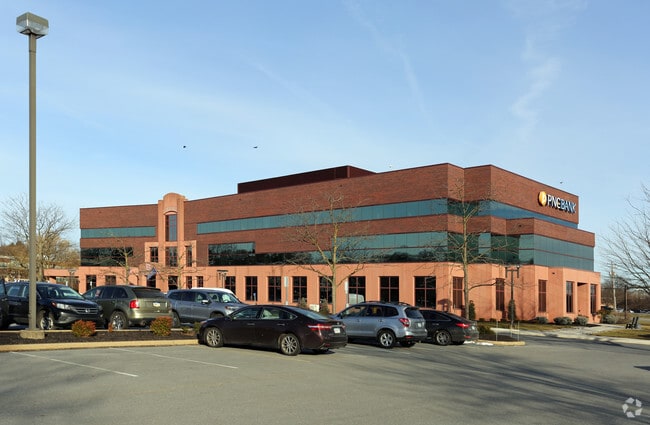
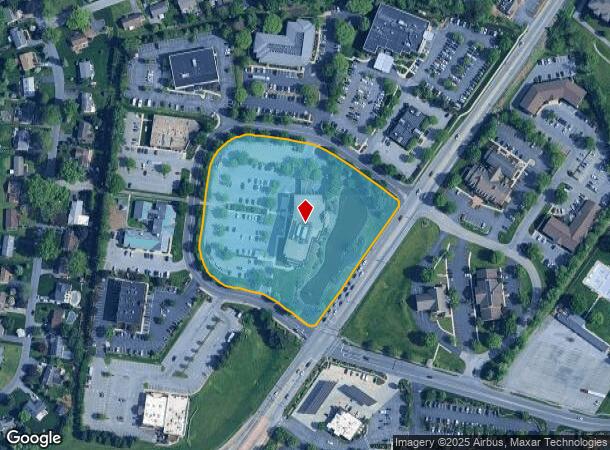
101 N Pointe Blvd
Lancaster, PA
Subdivision Plan For Harvest Meadow
390-81643-0-0000
101 NORTH POINTE BLVD
Financialbuilding
Lancaster
X
Pennsylvania
42071C0358F
1
2024
5.20 AC
2025
Lancaster County
011803
Philadelphia
50,291 SF
DEMOGRAPHICS near 101 N Pointe Blvd
1 Mile
3 Mile
5 Mile
2024 Total Population
9,256
106,212
184,179
2029 Population
9,322
107,279
185,720
Pop Growth 2024-2029
+ 0.71%
+ 1.00%
+ 0.84%
Average Age
42
40
41
2024 Total Households
3,567
40,772
70,496
HH Growth 2024-2029
+ 0.62%
+ 0.97%
+ 0.80%
Median Household Inc
$83,987
$69,445
$74,540
Avg Household Size
2.40
2.40
2.40
2024 Avg HH Vehicles
2.00
2.00
2.00
Median Home Value
$249,609
$241,004
$248,028
Median Year Built
1967
1959
1970
Nearby Places
Map Layers
Map Styles
 Street
 Aerial
- Restaurants
- Banks
- Shops
- Fitness
- Groceries
PUBLIC TRANSPORTATION
COMMUTER RAIL
DRIVE
WALK
Distance
3 min
1.5 mi
AIRPORT
Harrisburg International
DRIVE
WALK
Distance
Harrisburg International
40 min
31.1 mi
Freight Ports
Port Newark Container Terminal
DRIVE
WALK
Distance
Port Newark Container Terminal
80 min
48.8 mi
SALE & LEASE HISTORY
LISTING DATE
SALE/LEASE

Sep 25, 2016
For Lease
Sep 06, 2019
For Lease
Nearby Properties
Address
Land Use
TOTAL SIZE
Lot Size
Zoning
Address
Land Use
TOTAL SIZE
Lot Size
Zoning
822,920 SF
97.54 AC
HCD
Address
Land Use
TOTAL SIZE
Lot Size
Zoning
1,603,151 SF
104.89 AC
C3
Address
Land Use
TOTAL SIZE
Lot Size
Zoning
1,120,221 SF
8.40 AC
Address
Land Use
TOTAL SIZE
Lot Size
Zoning
1,070,497 SF
149.62 AC
Address
Land Use
TOTAL SIZE
Lot Size
Zoning
1,003,686 SF
127.66 AC
HR
Address
Land Use
TOTAL SIZE
Lot Size
Zoning
822,447 SF
77.29 AC
Address
Land Use
TOTAL SIZE
Lot Size
Zoning
871,695 SF
69.40 AC
R2
Address
Land Use
TOTAL SIZE
Lot Size
Zoning
206,666 SF
1 AC
CB1
Address
Land Use
TOTAL SIZE
Lot Size
Zoning
712,737 SF
52.50 AC
R2
Address
Land Use
TOTAL SIZE
Lot Size
Zoning
269,860 SF
0.90 AC
CB1
Address
Land Use
TOTAL SIZE
Lot Size
Zoning
315,373 SF
4.73 AC
DF
Address
Land Use
TOTAL SIZE
Lot Size
Zoning
678,995 SF
96.17 AC
Address
Land Use
TOTAL SIZE
Lot Size
Zoning
275,959 SF
68.50 AC
IN
Address
Land Use
TOTAL SIZE
Lot Size
Zoning
233,738 SF
34.10 AC
Address
Land Use
TOTAL SIZE
Lot Size
Zoning
642,651 SF
2.16 AC
CA
Address
Land Use
TOTAL SIZE
Lot Size
Zoning
308,727 SF
11.37 AC
Address
Land Use
TOTAL SIZE
Lot Size
Zoning
178,234 SF
0.78 AC
CB
Address
Land Use
TOTAL SIZE
Lot Size
Zoning
283,042 SF
17.50 AC
Address
Land Use
TOTAL SIZE
Lot Size
Zoning
193,864 SF
9 AC
Address
Land Use
TOTAL SIZE
Lot Size
Zoning
203,415 SF
10.74 AC
Address
Land Use
TOTAL SIZE
Lot Size
Zoning
99,894 SF
21.88 AC
Address
Land Use
TOTAL SIZE
Lot Size
Zoning
234,386 SF
15.30 AC
MU
Address
Land Use
TOTAL SIZE
Lot Size
Zoning
254,079 SF
21.54 AC
Address
Land Use
TOTAL SIZE
Lot Size
Zoning
234,681 SF
7.50 AC
MU
Address
Land Use
TOTAL SIZE
Lot Size
Zoning
223,327 SF
21.80 AC
B-4
Address
Land Use
TOTAL SIZE
Lot Size
Zoning
203,942 SF
21.22 AC
B-4
Address
Land Use
TOTAL SIZE
Lot Size
Zoning
691,290 SF
3 AC
Address
Land Use
TOTAL SIZE
Lot Size
Zoning
372,708 SF
50.40 AC
HR
Address
Land Use
TOTAL SIZE
Lot Size
Zoning
246,742 SF
12.49 AC
B-4
Address
Land Use
TOTAL SIZE
Lot Size
Zoning
125,073 SF
19.07 AC
I
The World's #1 Commercial Real Estate Marketplace
Connect with us
© 2025 CoStar Group
The information above has been obtained from sources believed reliable. While we do not doubt its accuracy we have not verified it and make no guarantee, warranty or representation about it. It is your responsibility to independently confirm its accuracy and completeness. Any projections, opinions, assumptions, or estimates used are for example only and do not represent the current or future performance of the property. The value of this transaction to you depends on tax and other factors which should be evaluated by your tax, financial, and legal advisors. You and your advisors should conduct a careful, independent investigation of the property to determine to your satisfaction the suitability of the property for your needs.