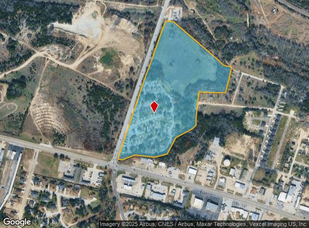
Property Record
101 N Roy Reynolds Dr, Harker Heights, TX 76548

NEARBY LISTINGS FOR SALE OR LEASE
Property Detail
101 N Roy Reynolds Dr
Killeen-Temple, TX
Open Air Resort Harker Heights
77037
OPEN AIR RESORT HARKER HEIGHTS, BLOCK 001, LOT 0001, ACRES 31.36
Commercialnec
Bell
AE
Texas
48027C0285E
1
2024
31.36 AC
2025
Outlying Bell County
022001
Killeen/Temple/Fort Hood
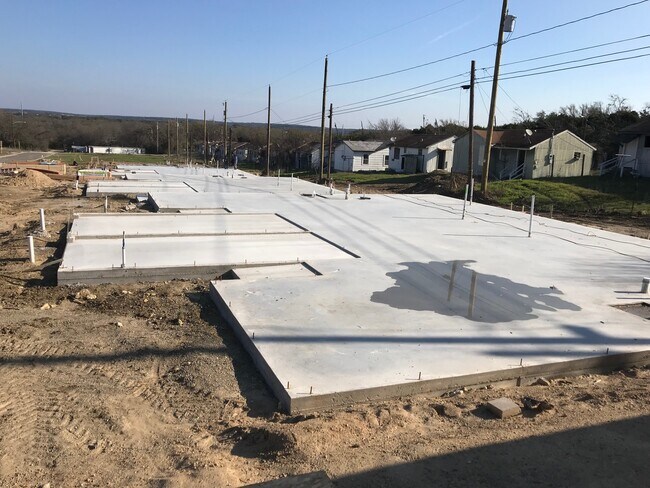
2,623 SF
DEMOGRAPHICS near 101 N Roy Reynolds Dr
1 Mile
3 Mile
5 Mile
2024 Total Population
4,553
68,885
151,241
2029 Population
5,201
77,032
169,679
Pop Growth 2024-2029
+ 14.23%
+ 11.83%
+ 12.19%
Average Age
35
35
34
2024 Total Households
1,743
26,444
56,405
HH Growth 2024-2029
+ 14.40%
+ 12.20%
+ 12.61%
Median Household Inc
$33,416
$54,320
$52,627
Avg Household Size
2.50
2.50
2.60
2024 Avg HH Vehicles
2.00
2.00
2.00
Median Home Value
$111,765
$166,828
$184,217
Median Year Built
1985
1990
1992
Nearby Places
Map Layers
Map Styles
 Street
 Aerial
- Restaurants
- Banks
- Shops
- Fitness
- Groceries
PUBLIC TRANSPORTATION
AIRPORT
Killeen Municipal
DRIVE
WALK
Distance
Killeen Municipal
5 min
1.2 mi
Robert Gray AAF
DRIVE
WALK
Distance
Robert Gray AAF
26 min
15.0 mi
Freight Ports
Port of Houston
DRIVE
WALK
Distance
Port of Houston
252 min
198.3 mi
SALE & LEASE HISTORY
LISTING DATE
SALE/LEASE

Jan 08, 2020
For Sale
Nearby Properties
Address
Land Use
TOTAL SIZE
Lot Size
Zoning
Address
Land Use
TOTAL SIZE
Lot Size
Zoning
4 SF
55.08 AC
Address
Land Use
TOTAL SIZE
Lot Size
Zoning
194,952 SF
38.61 AC
Address
Land Use
TOTAL SIZE
Lot Size
Zoning
233,780 SF
45.21 AC
Address
Land Use
TOTAL SIZE
Lot Size
Zoning
Address
Land Use
TOTAL SIZE
Lot Size
Zoning
233,807 SF
16.12 AC
Address
Land Use
TOTAL SIZE
Lot Size
Zoning
386,344 SF
171.40 AC
B-5
Address
Land Use
TOTAL SIZE
Lot Size
Zoning
133,210 SF
8.52 AC
R-3
Address
Land Use
TOTAL SIZE
Lot Size
Zoning
200,345 SF
42.44 AC
CUP
Address
Land Use
TOTAL SIZE
Lot Size
Zoning
152,304 SF
68.80 AC
Address
Land Use
TOTAL SIZE
Lot Size
Zoning
1 SF
18.38 AC
Address
Land Use
TOTAL SIZE
Lot Size
Zoning
160,143 SF
13.30 AC
Address
Land Use
TOTAL SIZE
Lot Size
Zoning
1 SF
30 AC
Address
Land Use
TOTAL SIZE
Lot Size
Zoning
366,112 SF
44.17 AC
Address
Land Use
TOTAL SIZE
Lot Size
Zoning
13,000 SF
31.72 AC
Address
Land Use
TOTAL SIZE
Lot Size
Zoning
151,969 SF
10 AC
R-3
Address
Land Use
TOTAL SIZE
Lot Size
Zoning
154,910 SF
9.38 AC
Address
Land Use
TOTAL SIZE
Lot Size
Zoning
146,182 SF
8.59 AC
Address
Land Use
TOTAL SIZE
Lot Size
Zoning
114,585 SF
4.64 AC
Address
Land Use
TOTAL SIZE
Lot Size
Zoning
132,202 SF
11.52 AC
R-3
Address
Land Use
TOTAL SIZE
Lot Size
Zoning
133,648 SF
6.52 AC
Address
Land Use
TOTAL SIZE
Lot Size
Zoning
62,226 SF
0.68 AC
Address
Land Use
TOTAL SIZE
Lot Size
Zoning
89,117 SF
5.31 AC
Address
Land Use
TOTAL SIZE
Lot Size
Zoning
152,393 SF
9.78 AC
Address
Land Use
TOTAL SIZE
Lot Size
Zoning
121,285 SF
11.75 AC
Address
Land Use
TOTAL SIZE
Lot Size
Zoning
41,832 SF
4.30 AC
Address
Land Use
TOTAL SIZE
Lot Size
Zoning
237,206 SF
3.80 AC
Address
Land Use
TOTAL SIZE
Lot Size
Zoning
210,437 SF
19.98 AC
Address
Land Use
TOTAL SIZE
Lot Size
Zoning
120,948 SF
32.68 AC
Address
Land Use
TOTAL SIZE
Lot Size
Zoning
108,964 SF
4.50 AC
Address
Land Use
TOTAL SIZE
Lot Size
Zoning
2,233 SF
29.99 AC
The World's #1 Commercial Real Estate Marketplace
Connect with us
© 2025 CoStar Group
The information above has been obtained from sources believed reliable. While we do not doubt its accuracy we have not verified it and make no guarantee, warranty or representation about it. It is your responsibility to independently confirm its accuracy and completeness. Any projections, opinions, assumptions, or estimates used are for example only and do not represent the current or future performance of the property. The value of this transaction to you depends on tax and other factors which should be evaluated by your tax, financial, and legal advisors. You and your advisors should conduct a careful, independent investigation of the property to determine to your satisfaction the suitability of the property for your needs.