Property Record
101 N Tyson Rd, Bruce, MS 38915
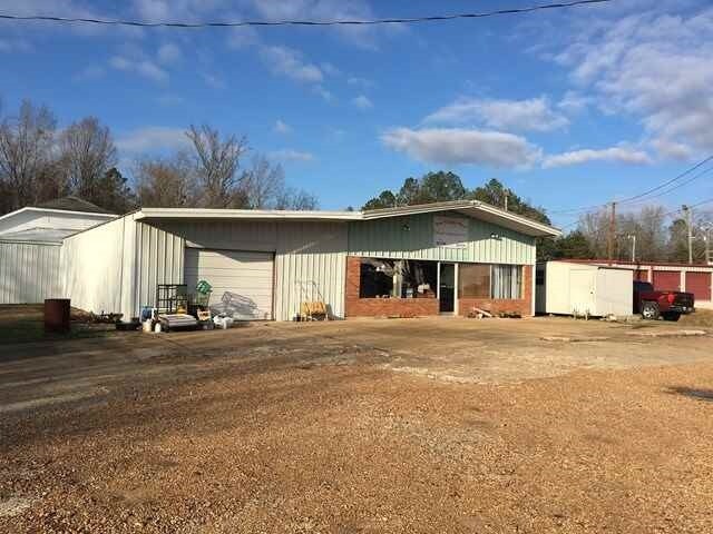

Property Detail
101 N Tyson Rd
080706-031-00-36
LOT PT A BLK 19
Publicstorage
CALHOUN
B and X Area of moderate flood hazard, usually the area between the limits of the 100-year and 500-year floods.
Mississippi
2025
a
2025
0.80 AC
950200
Tupelo/North Area
3,000 SF
Other Market Areas
NEARBY LISTINGS FOR SALE OR LEASE
-
-
View all Bruce listings for sale on LoopNet.com
DEMOGRAPHICS near 101 N Tyson Rd
1 mile
3 mile
5 mile
2025 Total Population
1,080
2,289
3,744
2030 Population
1,001
2,178
3,632
Pop Growth 2025-2030
(7.31%)
(4.85%)
(2.99%)
Average Age
43
44
44
2025 Total Households
500
992
1,566
HH Growth 2025-2030
(7.80%)
(5.34%)
(3.38%)
Median Household Inc
$29,090
$36,647
$40,824
Avg Household Size
2.10
2.20
2.30
2025 Avg HH Vehicles
2.00
2.00
2.00
Median Home Value
$86,301
$82,671
$82,526
Median Year Built
1976
1977
1978
Nearby Places
Map Layers
Map Styles
 Street
 Aerial
Transit
 Traffic
 Biking
Places
Listings with unknown addresses are not visible on the map
- Restaurants
- Banks
- Shops
- Fitness
- Groceries
SALE & LEASE HISTORY
LISTING DATE
SALE/LEASE

Nov 20, 2017
For Sale
Nearby Properties
Address
Land Use
TOTAL SIZE
Lot Size
Zoning
Address
Land Use
TOTAL SIZE
Lot Size
Zoning
194,250 SF
24 AC
Address
Land Use
TOTAL SIZE
Lot Size
Zoning
41,400 SF
4.60 AC
Address
Land Use
TOTAL SIZE
Lot Size
Zoning
182,074 SF
15.50 AC
Address
Land Use
TOTAL SIZE
Lot Size
Zoning
30,094 SF
4.20 AC
Address
Land Use
TOTAL SIZE
Lot Size
Zoning
100,450 SF
14.50 AC
Address
Land Use
TOTAL SIZE
Lot Size
Zoning
8,993 SF
9.60 AC
Address
Land Use
TOTAL SIZE
Lot Size
Zoning
2,708 SF
4.20 AC
Address
Land Use
TOTAL SIZE
Lot Size
Zoning
4,211 SF
0.90 AC
Address
Land Use
TOTAL SIZE
Lot Size
Zoning
6,821 SF
2.20 AC
Address
Land Use
TOTAL SIZE
Lot Size
Zoning
17,100 SF
9.60 AC
Address
Land Use
TOTAL SIZE
Lot Size
Zoning
15,727 SF
1 AC
Address
Land Use
TOTAL SIZE
Lot Size
Zoning
24,474 SF
2.70 AC
Address
Land Use
TOTAL SIZE
Lot Size
Zoning
8,930 SF
0.30 AC
Address
Land Use
TOTAL SIZE
Lot Size
Zoning
4,047 SF
0.20 AC
Address
Land Use
TOTAL SIZE
Lot Size
Zoning
36,540 SF
1.90 AC
Address
Land Use
TOTAL SIZE
Lot Size
Zoning
3,766 SF
1.09 AC
Address
Land Use
TOTAL SIZE
Lot Size
Zoning
12,972 SF
1.70 AC
Address
Land Use
TOTAL SIZE
Lot Size
Zoning
8,208 SF
0.20 AC
Address
Land Use
TOTAL SIZE
Lot Size
Zoning
2,697 SF
0.30 AC
Address
Land Use
TOTAL SIZE
Lot Size
Zoning
1,604 SF
0.40 AC
Address
Land Use
TOTAL SIZE
Lot Size
Zoning
1,520 SF
0.50 AC
Address
Land Use
TOTAL SIZE
Lot Size
Zoning
3,660 SF
0.08 AC
Address
Land Use
TOTAL SIZE
Lot Size
Zoning
4,347 SF
2.10 AC
Address
Land Use
TOTAL SIZE
Lot Size
Zoning
7,500 SF
0.50 AC
Address
Land Use
TOTAL SIZE
Lot Size
Zoning
2,890 SF
0.50 AC
Address
Land Use
TOTAL SIZE
Lot Size
Zoning
3,037 SF
0.52 AC
Address
Land Use
TOTAL SIZE
Lot Size
Zoning
7,308 SF
1.07 AC
Address
Land Use
TOTAL SIZE
Lot Size
Zoning
2,485 SF
0.80 AC
Address
Land Use
TOTAL SIZE
Lot Size
Zoning
4,788 SF
0.20 AC
The World's #1 Commercial Real Estate Marketplace
Connect with us
© 2026 CoStar Group
The information above has been obtained from sources believed reliable. While we do not doubt its accuracy we have not verified it and make no guarantee, warranty or representation about it. It is your responsibility to independently confirm its accuracy and completeness. Any projections, opinions, assumptions, or estimates used are for example only and do not represent the current or future performance of the property. The value of this transaction to you depends on tax and other factors which should be evaluated by your tax, financial, and legal advisors. You and your advisors should conduct a careful, independent investigation of the property to determine to your satisfaction the suitability of the property for your needs.