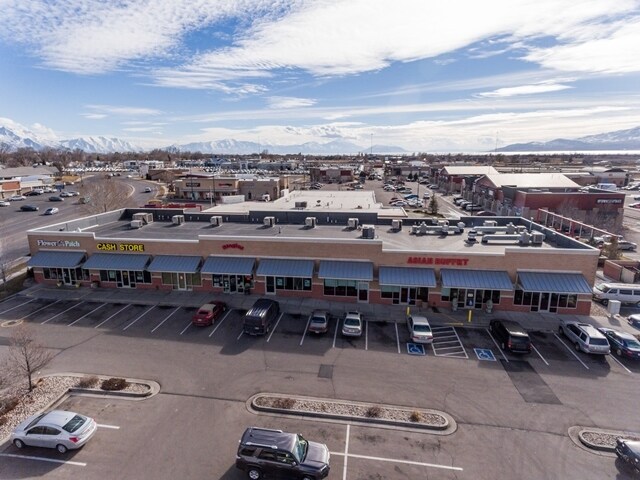
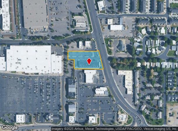
Property Record
101 N West State Rd, American Fork, UT 84003


NEARBY LISTINGS FOR SALE OR LEASE
Property Detail
101 N West State Rd
Salt Lake City
Alpine Valley Center Sub
Provo-Orem, UT
LOT 8, ALPINE VALLEY CENTER SUBDV. AREA 1.265 AC.
34-349-0008
Utah
Regionalshoppingcenterormallwithanchorstore
Utah
2024
8
2025
1.26 AC
000207
Utah County
12,000 SF
DEMOGRAPHICS near 101 N West State Rd
1 Mile
3 Mile
5 Mile
2024 Total Population
10,954
77,683
168,242
2029 Population
12,793
90,838
196,776
Pop Growth 2024-2029
+ 16.79%
+ 16.93%
+ 16.96%
Average Age
32
32
32
2024 Total Households
3,312
22,285
46,402
HH Growth 2024-2029
+ 17.09%
+ 17.37%
+ 17.34%
Median Household Inc
$84,525
$94,657
$106,400
Avg Household Size
3.30
3.40
3.60
2024 Avg HH Vehicles
2.00
2.00
2.00
Median Home Value
$422,231
$480,292
$510,954
Median Year Built
1994
2001
2003
Nearby Places
Map Layers
Map Styles
 Street
 Aerial
- Restaurants
- Banks
- Shops
- Fitness
- Groceries
PUBLIC TRANSPORTATION
AIRPORT
Salt Lake City International
DRIVE
WALK
Distance
Salt Lake City International
34 min
35.1 mi
Freight Ports
Port of Long Beach
DRIVE
WALK
Distance
Port of Long Beach
1 min
576.1 mi
SALE & LEASE HISTORY
LISTING DATE
SALE/LEASE

Sep 24, 2016
For Sale
Sep 24, 2016
For Sale
Mar 09, 2017
For Sale
Jan 31, 2023
For Lease
Feb 17, 2021
For Lease
Feb 01, 2017
For Lease
Feb 01, 2017
For Sale
Nearby Properties
Address
Land Use
TOTAL SIZE
Lot Size
Zoning
Address
Land Use
TOTAL SIZE
Lot Size
Zoning
400,684 SF
10.39 AC
Address
Land Use
TOTAL SIZE
Lot Size
Zoning
322,826 SF
9.53 AC
Address
Land Use
TOTAL SIZE
Lot Size
Zoning
194,977 SF
8.18 AC
Address
Land Use
TOTAL SIZE
Lot Size
Zoning
359,445 SF
6.46 AC
Address
Land Use
TOTAL SIZE
Lot Size
Zoning
305,553 SF
13.08 AC
Address
Land Use
TOTAL SIZE
Lot Size
Zoning
327,092 SF
14.61 AC
Address
Land Use
TOTAL SIZE
Lot Size
Zoning
146,939 SF
36.63 AC
Address
Land Use
TOTAL SIZE
Lot Size
Zoning
268,989 SF
12.78 AC
Address
Land Use
TOTAL SIZE
Lot Size
Zoning
8.99 AC
Address
Land Use
TOTAL SIZE
Lot Size
Zoning
154,800 SF
9.14 AC
Address
Land Use
TOTAL SIZE
Lot Size
Zoning
227,030 SF
21.91 AC
Address
Land Use
TOTAL SIZE
Lot Size
Zoning
213,863 SF
11.71 AC
Address
Land Use
TOTAL SIZE
Lot Size
Zoning
201,838 SF
8.83 AC
Address
Land Use
TOTAL SIZE
Lot Size
Zoning
141,635 SF
10.58 AC
Address
Land Use
TOTAL SIZE
Lot Size
Zoning
182,338 SF
7.97 AC
Address
Land Use
TOTAL SIZE
Lot Size
Zoning
153,790 SF
12.07 AC
Address
Land Use
TOTAL SIZE
Lot Size
Zoning
200,016 SF
8.82 AC
Address
Land Use
TOTAL SIZE
Lot Size
Zoning
122,777 SF
6.68 AC
Address
Land Use
TOTAL SIZE
Lot Size
Zoning
141,204 SF
11.96 AC
Address
Land Use
TOTAL SIZE
Lot Size
Zoning
149,937 SF
13.49 AC
Address
Land Use
TOTAL SIZE
Lot Size
Zoning
409,362 SF
29.53 AC
Address
Land Use
TOTAL SIZE
Lot Size
Zoning
102,751 SF
6.20 AC
Address
Land Use
TOTAL SIZE
Lot Size
Zoning
143,438 SF
7.43 AC
Address
Land Use
TOTAL SIZE
Lot Size
Zoning
100,814 SF
8.22 AC
Address
Land Use
TOTAL SIZE
Lot Size
Zoning
62,104 SF
8.97 AC
Address
Land Use
TOTAL SIZE
Lot Size
Zoning
94,851 SF
6.10 AC
Address
Land Use
TOTAL SIZE
Lot Size
Zoning
172,506 SF
9.99 AC
Address
Land Use
TOTAL SIZE
Lot Size
Zoning
110,561 SF
6.47 AC
Address
Land Use
TOTAL SIZE
Lot Size
Zoning
94,571 SF
6.20 AC
Address
Land Use
TOTAL SIZE
Lot Size
Zoning
109,875 SF
5.43 AC
The World's #1 Commercial Real Estate Marketplace
Connect with us
© 2025 CoStar Group
The information above has been obtained from sources believed reliable. While we do not doubt its accuracy we have not verified it and make no guarantee, warranty or representation about it. It is your responsibility to independently confirm its accuracy and completeness. Any projections, opinions, assumptions, or estimates used are for example only and do not represent the current or future performance of the property. The value of this transaction to you depends on tax and other factors which should be evaluated by your tax, financial, and legal advisors. You and your advisors should conduct a careful, independent investigation of the property to determine to your satisfaction the suitability of the property for your needs.