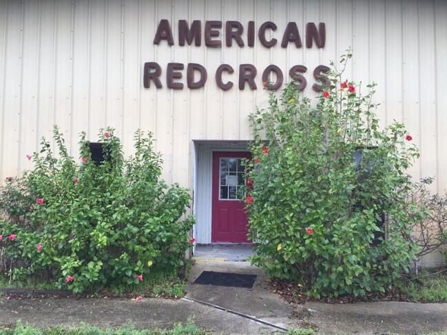
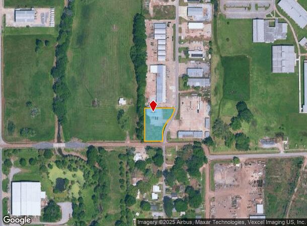
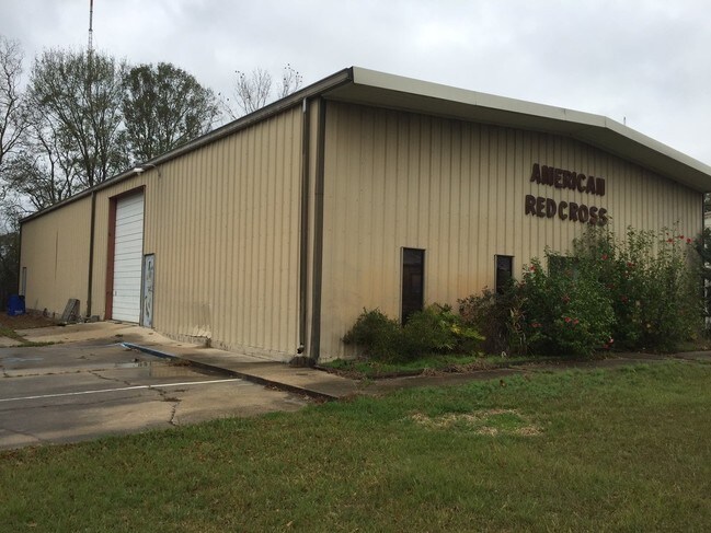
Property Record
101 Pod St, Lafayette, LA 70507
NEARBY LISTINGS FOR SALE OR LEASE
-
-
-
No Photo
-
-
-
-
View all Lafayette listings for sale on LoopNet.com
Property Detail
101 Pod St
Lafayette, LA
Safety Lane
6000138
SECS 21/22 T9S R4E (0.760 AC)(1983-12417 PLAT) (KNOWN AS LOT 12 OF SAFETY LANE INDUSTRIAL PARK) (FORMERLY P TR 1 (0.811) 167 FT FR ON SUNBEAM LN) (1980-25643 LESS (.90 AC) FOR 50' ROAD)
Warehouse
Lafayette
AH
Louisiana
22055C0160J
12
2024
0.76 AC
2024
Greater Lafayette
001001
Lafayette
5,000 SF
DEMOGRAPHICS near 101 Pod St
1 mile
3 mile
5 mile
2024 Total Population
2,783
53,621
122,888
2029 Population
2,920
56,967
130,482
Pop Growth 2024-2029
+ 4.92%
+ 6.24%
+ 6.18%
Average Age
36
39
39
2024 Total Households
1,170
22,724
51,606
HH Growth 2024-2029
+ 4.53%
+ 6.20%
+ 6.17%
Median Household Inc
$26,753
$40,434
$47,297
Avg Household Size
2.20
2.20
2.30
2024 Avg HH Vehicles
1.00
1.00
2.00
Median Home Value
$73,735
$152,468
$179,204
Median Year Built
1976
1976
1978
Nearby Places
Map Layers
Map Styles
 Street
 Aerial
Transit
 Traffic
 Biking
Places
Listings with unknown addresses are not visible on the map
- Restaurants
- Banks
- Shops
- Fitness
- Groceries
PUBLIC TRANSPORTATION
COMMUTER RAIL
Lafayette Amtrak Station (Sunset Limited - Amtrak)
Drive
Walk
Distance
Lafayette Amtrak Station (Sunset Limited - Amtrak)
8 min
4.1 mi
AIRPORT
Lafayette Regional/Paul Fournet Field
Drive
Walk
Distance
Lafayette Regional/Paul Fournet Field
13 min
6.4 mi
Freight Ports
Port of Iberia
Drive
Walk
Distance
Port of Iberia
38 min
27.4 mi
SALE & LEASE HISTORY
LISTING DATE
SALE/LEASE

Feb 02, 2017
For Sale
Nearby Properties
Address
Land Use
TOTAL SIZE
Lot Size
Zoning
Address
Land Use
TOTAL SIZE
Lot Size
Zoning
21.64 AC
Address
Land Use
TOTAL SIZE
Lot Size
Zoning
4.20 AC
Address
Land Use
TOTAL SIZE
Lot Size
Zoning
28.09 AC
Address
Land Use
TOTAL SIZE
Lot Size
Zoning
19.73 AC
Address
Land Use
TOTAL SIZE
Lot Size
Zoning
249,875 SF
29.76 AC
Address
Land Use
TOTAL SIZE
Lot Size
Zoning
12.34 AC
Address
Land Use
TOTAL SIZE
Lot Size
Zoning
96.54 AC
Address
Land Use
TOTAL SIZE
Lot Size
Zoning
221,760 SF
0.67 AC
Address
Land Use
TOTAL SIZE
Lot Size
Zoning
132,882 SF
13.98 AC
Address
Land Use
TOTAL SIZE
Lot Size
Zoning
423,600 SF
24.16 AC
Address
Land Use
TOTAL SIZE
Lot Size
Zoning
Address
Land Use
TOTAL SIZE
Lot Size
Zoning
84,009 SF
6.90 AC
Address
Land Use
TOTAL SIZE
Lot Size
Zoning
47,249 SF
22.17 AC
Address
Land Use
TOTAL SIZE
Lot Size
Zoning
123,164 SF
2.11 AC
Address
Land Use
TOTAL SIZE
Lot Size
Zoning
7.77 AC
Address
Land Use
TOTAL SIZE
Lot Size
Zoning
203,442 SF
39.38 AC
Address
Land Use
TOTAL SIZE
Lot Size
Zoning
87,868 SF
3.02 AC
Address
Land Use
TOTAL SIZE
Lot Size
Zoning
67,672 SF
10.18 AC
Address
Land Use
TOTAL SIZE
Lot Size
Zoning
2.19 AC
Address
Land Use
TOTAL SIZE
Lot Size
Zoning
95,667 SF
4.30 AC
Address
Land Use
TOTAL SIZE
Lot Size
Zoning
139,738 SF
11.05 AC
Address
Land Use
TOTAL SIZE
Lot Size
Zoning
150,000 SF
0.85 AC
Address
Land Use
TOTAL SIZE
Lot Size
Zoning
47,310 SF
3.80 AC
Address
Land Use
TOTAL SIZE
Lot Size
Zoning
Address
Land Use
TOTAL SIZE
Lot Size
Zoning
4.30 AC
Address
Land Use
TOTAL SIZE
Lot Size
Zoning
58,359 SF
21.04 AC
Address
Land Use
TOTAL SIZE
Lot Size
Zoning
162,100 SF
3.04 AC
Address
Land Use
TOTAL SIZE
Lot Size
Zoning
78,612 SF
5.84 AC
Address
Land Use
TOTAL SIZE
Lot Size
Zoning
10.18 AC
Address
Land Use
TOTAL SIZE
Lot Size
Zoning
9.75 AC
The World's #1 Commercial Real Estate Marketplace
Connect with us
© 2026 CoStar Group
The information above has been obtained from sources believed reliable. While we do not doubt its accuracy we have not verified it and make no guarantee, warranty or representation about it. It is your responsibility to independently confirm its accuracy and completeness. Any projections, opinions, assumptions, or estimates used are for example only and do not represent the current or future performance of the property. The value of this transaction to you depends on tax and other factors which should be evaluated by your tax, financial, and legal advisors. You and your advisors should conduct a careful, independent investigation of the property to determine to your satisfaction the suitability of the property for your needs.