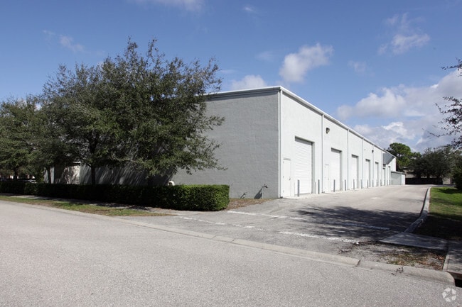
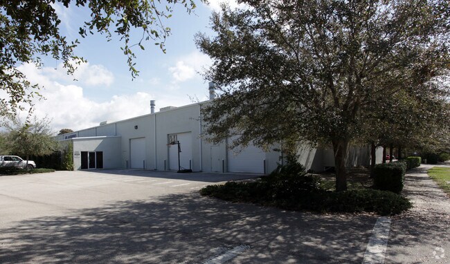
Property Record
101 Pond Cypress Rd, Venice, FL 34292
NEARBY LISTINGS FOR SALE OR LEASE
Property Detail
101 Pond Cypress Rd
0397-13-1016
Scibc North Land
Lightindustrial
UNITS 16, 17 & 18, SCIBC NORTH LAND, CONTAINING 2 C-AC M/L
X
Sarasota
12115C0332G
Florida
2024
2 AC
2025
Sarasota Outlying
002716
Tampa/St Petersburg
25,250 SF
North Port-Sarasota-Bradenton, FL
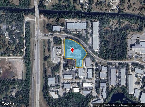
DEMOGRAPHICS near 101 Pond Cypress Rd
1 Mile
3 Mile
5 Mile
2024 Total Population
2,536
34,637
89,194
2029 Population
3,015
40,419
104,057
Pop Growth 2024-2029
+ 18.89%
+ 16.69%
+ 16.66%
Average Age
54
61
59
2024 Total Households
1,149
17,430
44,929
HH Growth 2024-2029
+ 18.89%
+ 16.59%
+ 16.72%
Median Household Inc
$86,274
$76,840
$71,314
Avg Household Size
2.20
1.90
1.90
2024 Avg HH Vehicles
2.00
2.00
2.00
Median Home Value
$402,490
$357,147
$336,529
Median Year Built
2010
2000
1990
Nearby Places
Map Layers
Map Styles
 Street
 Aerial
- Restaurants
- Banks
- Shops
- Fitness
- Groceries
PUBLIC TRANSPORTATION
AIRPORT
Sarasota/Bradenton International
DRIVE
WALK
Distance
Sarasota/Bradenton International
40 min
28.8 mi
Punta Gorda
DRIVE
WALK
Distance
Punta Gorda
41 min
33.3 mi
Freight Ports
Port Manatee
DRIVE
WALK
Distance
Port Manatee
51 min
41.3 mi
Nearby Properties
Address
Land Use
TOTAL SIZE
Lot Size
Zoning
Address
Land Use
TOTAL SIZE
Lot Size
Zoning
738,835 SF
65.43 AC
LW
Address
Land Use
TOTAL SIZE
Lot Size
Zoning
26,265 SF
210.50 AC
RMH
Address
Land Use
TOTAL SIZE
Lot Size
Zoning
333,296 SF
16.80 AC
RMF3
Address
Land Use
TOTAL SIZE
Lot Size
Zoning
432,671 SF
48.53 AC
RMF2
Address
Land Use
TOTAL SIZE
Lot Size
Zoning
421,272 SF
31.96 AC
PUD
Address
Land Use
TOTAL SIZE
Lot Size
Zoning
273,036 SF
28.76 AC
RMF3
Address
Land Use
TOTAL SIZE
Lot Size
Zoning
238,850 SF
18.24 AC
LE
Address
Land Use
TOTAL SIZE
Lot Size
Zoning
263,056 SF
25.54 AC
LW
Address
Land Use
TOTAL SIZE
Lot Size
Zoning
191,373 SF
23.12 AC
RMF2
Address
Land Use
TOTAL SIZE
Lot Size
Zoning
48,681 SF
5 AC
OPI
Address
Land Use
TOTAL SIZE
Lot Size
Zoning
177,646 SF
5.23 AC
LE
Address
Land Use
TOTAL SIZE
Lot Size
Zoning
362,000 SF
41.51 AC
PID
Address
Land Use
TOTAL SIZE
Lot Size
Zoning
183,584 SF
14.54 AC
PUD
Address
Land Use
TOTAL SIZE
Lot Size
Zoning
252,213 SF
13.49 AC
LE
Address
Land Use
TOTAL SIZE
Lot Size
Zoning
81,883 SF
11.90 AC
CSC
Address
Land Use
TOTAL SIZE
Lot Size
Zoning
115,360 SF
14.60 AC
ILW
Address
Land Use
TOTAL SIZE
Lot Size
Zoning
146,990 SF
8.90 AC
CG
Address
Land Use
TOTAL SIZE
Lot Size
Zoning
63,549 SF
6.26 AC
OPI
Address
Land Use
TOTAL SIZE
Lot Size
Zoning
98,113 SF
12.05 AC
CSC
Address
Land Use
TOTAL SIZE
Lot Size
Zoning
78,975 SF
8.40 AC
RSF4
Address
Land Use
TOTAL SIZE
Lot Size
Zoning
66,899 SF
30.10 AC
GU
Address
Land Use
TOTAL SIZE
Lot Size
Zoning
121,747 SF
17.54 AC
OUE1
Address
Land Use
TOTAL SIZE
Lot Size
Zoning
101,219 SF
4.90 AC
OPI
Address
Land Use
TOTAL SIZE
Lot Size
Zoning
76,247 SF
13.89 AC
CG
Address
Land Use
TOTAL SIZE
Lot Size
Zoning
110,209 SF
12.55 AC
PID
Address
Land Use
TOTAL SIZE
Lot Size
Zoning
66.78 AC
RMF1
Address
Land Use
TOTAL SIZE
Lot Size
Zoning
70,220 SF
9.31 AC
LW
Address
Land Use
TOTAL SIZE
Lot Size
Zoning
125,001 SF
3.13 AC
CG
Address
Land Use
TOTAL SIZE
Lot Size
Zoning
8,040 SF
46.23 AC
RMH
Address
Land Use
TOTAL SIZE
Lot Size
Zoning
92,802 SF
4.78 AC
CN
The World's #1 Commercial Real Estate Marketplace
Connect with us
© 2025 CoStar Group
The information above has been obtained from sources believed reliable. While we do not doubt its accuracy we have not verified it and make no guarantee, warranty or representation about it. It is your responsibility to independently confirm its accuracy and completeness. Any projections, opinions, assumptions, or estimates used are for example only and do not represent the current or future performance of the property. The value of this transaction to you depends on tax and other factors which should be evaluated by your tax, financial, and legal advisors. You and your advisors should conduct a careful, independent investigation of the property to determine to your satisfaction the suitability of the property for your needs.