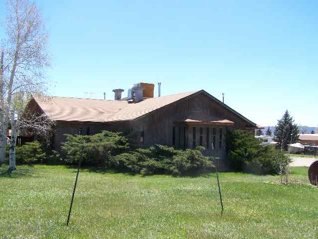
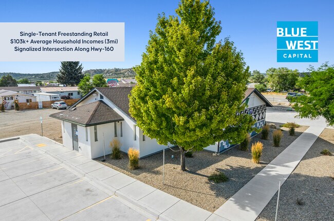
Property Record
101 E Railroad Ave, Mancos, CO 81328

Property Detail
101 E Railroad Ave
Commercialnec
SUBDIVISION: GEORGE BAUERS 2ND SUB BLOCK: 5 100FT X 166FT; B680 P804 R/464934
CMU
MONTEZUMA
B and X Area of moderate flood hazard, usually the area between the limits of the 100-year and 500-year floods.
Colorado
2025
0.38 AC
2025
Colorado Southwest Area
969100
Other Market Areas
2,980 SF
R004837
NEARBY LISTINGS FOR SALE OR LEASE
-
-
View all Mancos listings for sale on LoopNet.com
DEMOGRAPHICS near 101 E Railroad Ave
1 mile
3 mile
5 mile
2025 Total Population
1,447
2,096
2,924
2030 Population
1,498
2,170
3,033
Pop Growth 2025-2030
+ 3.52%
+ 3.53%
+ 3.73%
Average Age
46
46
46
2025 Total Households
633
917
1,276
HH Growth 2025-2030
+ 3.48%
+ 3.38%
+ 3.61%
Median Household Inc
$81,591
$82,516
$86,737
Avg Household Size
2.30
2.30
2.30
2025 Avg HH Vehicles
2.00
2.00
2.00
Median Home Value
$465,060
$466,528
$476,785
Median Year Built
1988
1988
1990
Nearby Places
Map Layers
Map Styles
 Street
 Aerial
Transit
 Traffic
 Biking
Places
Listings with unknown addresses are not visible on the map
- Restaurants
- Banks
- Shops
- Fitness
- Groceries
SALE & LEASE HISTORY
LISTING DATE
SALE/LEASE

Oct 10, 2025
For Sale
Nearby Properties
Address
Land Use
TOTAL SIZE
Lot Size
Zoning
Address
Land Use
TOTAL SIZE
Lot Size
Zoning
1.90 AC
INDHZ
Address
Land Use
TOTAL SIZE
Lot Size
Zoning
5,844 SF
1.87 AC
CMU
Address
Land Use
TOTAL SIZE
Lot Size
Zoning
1.30 AC
CMU
Address
Land Use
TOTAL SIZE
Lot Size
Zoning
34,176 SF
5.70 AC
LI
Address
Land Use
TOTAL SIZE
Lot Size
Zoning
36 AC
A/R 35+
Address
Land Use
TOTAL SIZE
Lot Size
Zoning
3,000 SF
3 AC
INDLZ
Address
Land Use
TOTAL SIZE
Lot Size
Zoning
35.34 AC
A/R 35+
Address
Land Use
TOTAL SIZE
Lot Size
Zoning
10,046 SF
1.10 AC
MFR-2
Address
Land Use
TOTAL SIZE
Lot Size
Zoning
2,573 SF
62.33 AC
A/R 35+
Address
Land Use
TOTAL SIZE
Lot Size
Zoning
4,200 SF
3.96 AC
COMZ
Address
Land Use
TOTAL SIZE
Lot Size
Zoning
1,500 SF
35.03 AC
A/R 35+
Address
Land Use
TOTAL SIZE
Lot Size
Zoning
152.99 AC
A/R 35+
Address
Land Use
TOTAL SIZE
Lot Size
Zoning
10,000 SF
52.65 AC
A/R 35+
Address
Land Use
TOTAL SIZE
Lot Size
Zoning
4,000 SF
375.45 AC
A-80+
Address
Land Use
TOTAL SIZE
Lot Size
Zoning
11,200 SF
1.13 AC
C
Address
Land Use
TOTAL SIZE
Lot Size
Zoning
12,466 SF
0.41 AC
C
Address
Land Use
TOTAL SIZE
Lot Size
Zoning
4.30 AC
A/R 3-9
Address
Land Use
TOTAL SIZE
Lot Size
Zoning
3,192 SF
4.41 AC
A/R 3-9
Address
Land Use
TOTAL SIZE
Lot Size
Zoning
4,813 SF
0.58 AC
CMU
Address
Land Use
TOTAL SIZE
Lot Size
Zoning
10,000 SF
203.87 AC
A/R 35+
Address
Land Use
TOTAL SIZE
Lot Size
Zoning
1,973 SF
0.40 AC
C
Address
Land Use
TOTAL SIZE
Lot Size
Zoning
3,463 SF
0.56 AC
CMU
Address
Land Use
TOTAL SIZE
Lot Size
Zoning
6,107 SF
0.20 AC
DMU
Address
Land Use
TOTAL SIZE
Lot Size
Zoning
0.49 AC
CMU
Address
Land Use
TOTAL SIZE
Lot Size
Zoning
1.11 AC
CMU
Address
Land Use
TOTAL SIZE
Lot Size
Zoning
154.15 AC
INDHZ
Address
Land Use
TOTAL SIZE
Lot Size
Zoning
6.58 AC
A/R 3-9
Address
Land Use
TOTAL SIZE
Lot Size
Zoning
60.05 AC
A/R 35+
Address
Land Use
TOTAL SIZE
Lot Size
Zoning
2,700 SF
76.10 AC
A/R 35+
The World's #1 Commercial Real Estate Marketplace
Connect with us
© 2026 CoStar Group
The information above has been obtained from sources believed reliable. While we do not doubt its accuracy we have not verified it and make no guarantee, warranty or representation about it. It is your responsibility to independently confirm its accuracy and completeness. Any projections, opinions, assumptions, or estimates used are for example only and do not represent the current or future performance of the property. The value of this transaction to you depends on tax and other factors which should be evaluated by your tax, financial, and legal advisors. You and your advisors should conduct a careful, independent investigation of the property to determine to your satisfaction the suitability of the property for your needs.