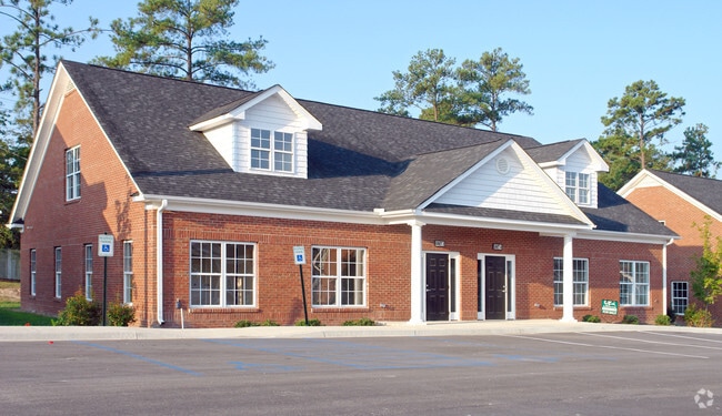
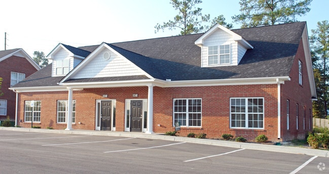
Property Record
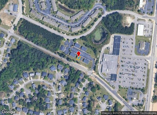
101 Rice Bent Way, Columbia, SC 29229

NEARBY LISTINGS FOR SALE OR LEASE
Property Detail
101 Rice Bent Way
Columbia, SC
Rice Creek Office Park
20310-07-08
Richland
Condominium
South Carolina
X
0.03 AC
45079C0143L
Northeast Columbia
2,255 SF
Columbia
DEMOGRAPHICS near 101 Rice Bent Way
1 Mile
3 Mile
5 Mile
2024 Total Population
9,441
64,062
108,012
2029 Population
9,607
64,975
109,768
Pop Growth 2024-2029
+ 1.76%
+ 1.43%
+ 1.63%
Average Age
37
37
38
2024 Total Households
3,687
23,632
41,216
HH Growth 2024-2029
+ 1.52%
+ 1.47%
+ 1.68%
Median Household Inc
$66,417
$73,572
$71,207
Avg Household Size
2.50
2.70
2.60
2024 Avg HH Vehicles
2.00
2.00
2.00
Median Home Value
$175,266
$206,785
$215,314
Median Year Built
2003
2003
2002
Nearby Places
Map Layers
Map Styles
 Street
 Aerial
- Restaurants
- Banks
- Shops
- Fitness
- Groceries
PUBLIC TRANSPORTATION
AIRPORT
Columbia Metro
DRIVE
WALK
Distance
Columbia Metro
46 min
26.5 mi
Nearby Properties
Address
Land Use
TOTAL SIZE
Lot Size
Zoning
Address
Land Use
TOTAL SIZE
Lot Size
Zoning
231,760 SF
23.84 AC
M-1
Address
Land Use
TOTAL SIZE
Lot Size
Zoning
83,808 SF
95.58 AC
PDD
Address
Land Use
TOTAL SIZE
Lot Size
Zoning
333,002 SF
8.39 AC
GC
Address
Land Use
TOTAL SIZE
Lot Size
Zoning
244,269 SF
9.54 AC
GC
Address
Land Use
TOTAL SIZE
Lot Size
Zoning
563.44 AC
OI
Address
Land Use
TOTAL SIZE
Lot Size
Zoning
309,478 SF
8.87 AC
PDD
Address
Land Use
TOTAL SIZE
Lot Size
Zoning
325,344 SF
71.41 AC
HI
Address
Land Use
TOTAL SIZE
Lot Size
Zoning
306,612 SF
20.94 AC
GC
Address
Land Use
TOTAL SIZE
Lot Size
Zoning
301,627 SF
25.08 AC
PDD
Address
Land Use
TOTAL SIZE
Lot Size
Zoning
232,148 SF
14.16 AC
PDD
Address
Land Use
TOTAL SIZE
Lot Size
Zoning
462,800 SF
104.82 AC
M-1
Address
Land Use
TOTAL SIZE
Lot Size
Zoning
147,916 SF
4.69 AC
OI
Address
Land Use
TOTAL SIZE
Lot Size
Zoning
91,672 SF
12.18 AC
GC
Address
Land Use
TOTAL SIZE
Lot Size
Zoning
51,803 SF
11.99 AC
M-1
Address
Land Use
TOTAL SIZE
Lot Size
Zoning
138,480 SF
23.02 AC
GC
Address
Land Use
TOTAL SIZE
Lot Size
Zoning
66,821 SF
6.32 AC
OI
Address
Land Use
TOTAL SIZE
Lot Size
Zoning
275,753 SF
26.21 AC
HI
Address
Land Use
TOTAL SIZE
Lot Size
Zoning
73,192 SF
6.12 AC
GC
Address
Land Use
TOTAL SIZE
Lot Size
Zoning
148,809 SF
17.52 AC
M-1
Address
Land Use
TOTAL SIZE
Lot Size
Zoning
129,017 SF
14.70 AC
PDD
Address
Land Use
TOTAL SIZE
Lot Size
Zoning
143,072 SF
12.61 AC
PDD
Address
Land Use
TOTAL SIZE
Lot Size
Zoning
75,893 SF
10 AC
PDD
Address
Land Use
TOTAL SIZE
Lot Size
Zoning
68,091 SF
4.35 AC
OI
Address
Land Use
TOTAL SIZE
Lot Size
Zoning
125,894 SF
7.77 AC
PDD
Address
Land Use
TOTAL SIZE
Lot Size
Zoning
73,901 SF
8.83 AC
PUD
Address
Land Use
TOTAL SIZE
Lot Size
Zoning
72,549 SF
2.49 AC
PDD
Address
Land Use
TOTAL SIZE
Lot Size
Zoning
37,971 SF
8.40 AC
PDD
Address
Land Use
TOTAL SIZE
Lot Size
Zoning
117,832 SF
10.82 AC
PDD
Address
Land Use
TOTAL SIZE
Lot Size
Zoning
86,776 SF
6.43 AC
OI
Address
Land Use
TOTAL SIZE
Lot Size
Zoning
75,470 SF
10.81 AC
GC
The World's #1 Commercial Real Estate Marketplace
Connect with us
© 2026 CoStar Group
The information above has been obtained from sources believed reliable. While we do not doubt its accuracy we have not verified it and make no guarantee, warranty or representation about it. It is your responsibility to independently confirm its accuracy and completeness. Any projections, opinions, assumptions, or estimates used are for example only and do not represent the current or future performance of the property. The value of this transaction to you depends on tax and other factors which should be evaluated by your tax, financial, and legal advisors. You and your advisors should conduct a careful, independent investigation of the property to determine to your satisfaction the suitability of the property for your needs.