Property Record
101 S Fir Ave, Gillette, WY 82716
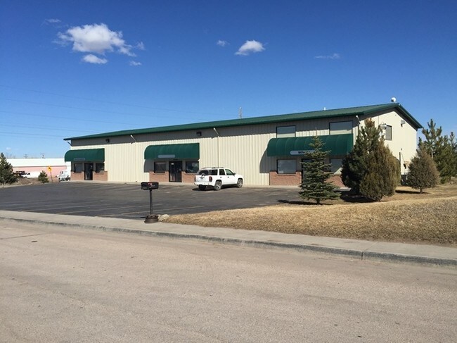

Property Detail
101 S Fir Ave
Gillette, WY
WESTSIDE ADD, LOT 1 BLOCK 10
R0005598
Campbell
Warehouse
Wyoming
B and X Area of moderate flood hazard, usually the area between the limits of the 100-year and 500-year floods.
1
2024
3.03 AC
2025
Wyoming Area
000600
Other Market Areas
7,000 SF
NEARBY LISTINGS FOR SALE OR LEASE
DEMOGRAPHICS near 101 S Fir Ave
1 mile
3 mile
5 mile
2025 Total Population
4,005
26,814
36,224
2030 Population
4,164
27,817
37,631
Pop Growth 2025-2030
+ 3.97%
+ 3.74%
+ 3.88%
Average Age
38
36
36
2025 Total Households
1,634
10,360
13,820
HH Growth 2025-2030
+ 4.10%
+ 3.83%
+ 3.98%
Median Household Inc
$59,032
$86,157
$88,486
Avg Household Size
2.30
2.50
2.50
2025 Avg HH Vehicles
2.00
2.00
2.00
Median Home Value
$230,579
$259,434
$265,486
Median Year Built
1976
1985
1989
Nearby Places
Map Layers
Map Styles
 Street
 Aerial
Transit
 Traffic
 Biking
Places
Listings with unknown addresses are not visible on the map
- Restaurants
- Banks
- Shops
- Fitness
- Groceries
Nearby Properties
Address
Land Use
TOTAL SIZE
Lot Size
Zoning
Address
Land Use
TOTAL SIZE
Lot Size
Zoning
212,478 SF
16.33 AC
Address
Land Use
TOTAL SIZE
Lot Size
Zoning
121,282 SF
7 AC
Address
Land Use
TOTAL SIZE
Lot Size
Zoning
112,541 SF
4.22 AC
Address
Land Use
TOTAL SIZE
Lot Size
Zoning
208,513 SF
11.57 AC
Address
Land Use
TOTAL SIZE
Lot Size
Zoning
95,399 SF
9.64 AC
Address
Land Use
TOTAL SIZE
Lot Size
Zoning
139,392 SF
7.35 AC
Address
Land Use
TOTAL SIZE
Lot Size
Zoning
101,890 SF
12.89 AC
Address
Land Use
TOTAL SIZE
Lot Size
Zoning
87,293 SF
6.15 AC
Address
Land Use
TOTAL SIZE
Lot Size
Zoning
121,543 SF
0.79 AC
Address
Land Use
TOTAL SIZE
Lot Size
Zoning
54,956 SF
1.85 AC
Address
Land Use
TOTAL SIZE
Lot Size
Zoning
121,307 SF
5.28 AC
Address
Land Use
TOTAL SIZE
Lot Size
Zoning
90,760 SF
3.96 AC
Address
Land Use
TOTAL SIZE
Lot Size
Zoning
70,450 SF
6.57 AC
Address
Land Use
TOTAL SIZE
Lot Size
Zoning
67,200 SF
4.89 AC
Address
Land Use
TOTAL SIZE
Lot Size
Zoning
53,670 SF
1.67 AC
Address
Land Use
TOTAL SIZE
Lot Size
Zoning
48,094 SF
2.64 AC
Address
Land Use
TOTAL SIZE
Lot Size
Zoning
65,966 SF
9.89 AC
Address
Land Use
TOTAL SIZE
Lot Size
Zoning
78,320 SF
7.52 AC
Address
Land Use
TOTAL SIZE
Lot Size
Zoning
53,373 SF
4.26 AC
Address
Land Use
TOTAL SIZE
Lot Size
Zoning
61,928 SF
3.63 AC
Address
Land Use
TOTAL SIZE
Lot Size
Zoning
42,891 SF
2.15 AC
Address
Land Use
TOTAL SIZE
Lot Size
Zoning
85,920 SF
3.25 AC
Address
Land Use
TOTAL SIZE
Lot Size
Zoning
65,512 SF
3.14 AC
Address
Land Use
TOTAL SIZE
Lot Size
Zoning
42,369 SF
40.97 AC
Address
Land Use
TOTAL SIZE
Lot Size
Zoning
41,466 SF
1.77 AC
Address
Land Use
TOTAL SIZE
Lot Size
Zoning
41,295 SF
7.61 AC
Address
Land Use
TOTAL SIZE
Lot Size
Zoning
86,272 SF
6.14 AC
Address
Land Use
TOTAL SIZE
Lot Size
Zoning
37,659 SF
2.87 AC
Address
Land Use
TOTAL SIZE
Lot Size
Zoning
53,110 SF
0.40 AC
Address
Land Use
TOTAL SIZE
Lot Size
Zoning
47,814 SF
2.15 AC
The World's #1 Commercial Real Estate Marketplace
Connect with us
© 2026 CoStar Group
The information above has been obtained from sources believed reliable. While we do not doubt its accuracy we have not verified it and make no guarantee, warranty or representation about it. It is your responsibility to independently confirm its accuracy and completeness. Any projections, opinions, assumptions, or estimates used are for example only and do not represent the current or future performance of the property. The value of this transaction to you depends on tax and other factors which should be evaluated by your tax, financial, and legal advisors. You and your advisors should conduct a careful, independent investigation of the property to determine to your satisfaction the suitability of the property for your needs.