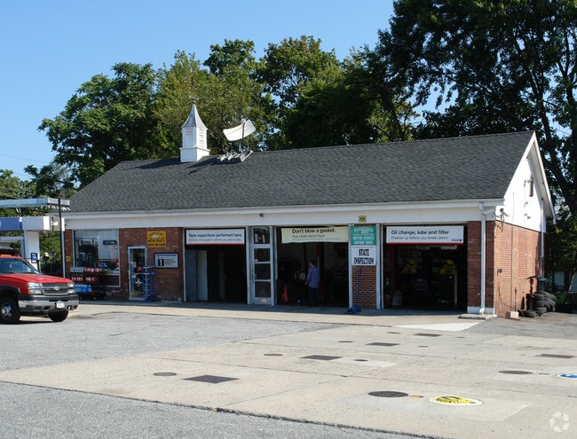
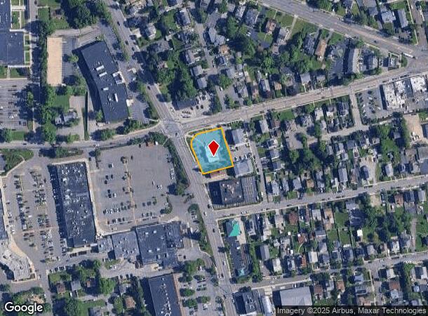
Property Record
101 S Ridge St, Port Chester, NY 10573
NEARBY LISTINGS FOR SALE OR LEASE
Property Detail
101 S Ridge St
4805-141-000-00027-001-0027-0000000
Westchester
Financialbuilding
New York
X
27.000
09001C0493G
0.52 AC
2025
East I-287 Corridor
2024
Westchester/So Connecticut
008301
New York-Jersey City-White Plains, NY-NJ
2,906 SF
DEMOGRAPHICS near 101 S Ridge St
1 Mile
3 Mile
5 Mile
2024 Total Population
21,956
81,201
170,942
2029 Population
20,877
79,245
167,705
Pop Growth 2024-2029
(4.91%)
(2.41%)
(1.89%)
Average Age
40
41
41
2024 Total Households
7,436
27,996
62,863
HH Growth 2024-2029
(4.99%)
(2.48%)
(1.88%)
Median Household Inc
$105,733
$132,411
$131,721
Avg Household Size
2.80
2.80
2.60
2024 Avg HH Vehicles
2.00
2.00
2.00
Median Home Value
$650,818
$884,672
$850,668
Median Year Built
1956
1959
1958
Nearby Places
- Restaurants
- Banks
- Shops
- Fitness
- Groceries
PUBLIC TRANSPORTATION
COMMUTER RAIL
Port Chester Station (New Haven Line - Metro-North Commuter Railroad Company (Metro-North))
DRIVE
WALK
Distance
Port Chester Station (New Haven Line - Metro-North Commuter Railroad Company (Metro-North))
2 min
20 min
1.1 mi
Rye Station (New Haven Line - Metro-North Commuter Railroad Company (Metro-North))
DRIVE
WALK
Distance
Rye Station (New Haven Line - Metro-North Commuter Railroad Company (Metro-North))
3 min
1.5 mi
AIRPORT
Westchester County
DRIVE
WALK
Distance
Westchester County
13 min
6.5 mi
LaGuardia
DRIVE
WALK
Distance
LaGuardia
40 min
24.4 mi
John F Kennedy International
DRIVE
WALK
Distance
John F Kennedy International
46 min
32.0 mi
Freight Ports
NY - Red Hook Container Terminal
DRIVE
WALK
Distance
NY - Red Hook Container Terminal
55 min
34.9 mi
Nearby Properties
Address
Land Use
TOTAL SIZE
Lot Size
Zoning
Address
Land Use
TOTAL SIZE
Lot Size
Zoning
5COMMUND
Address
Land Use
TOTAL SIZE
Lot Size
Zoning
80,427 SF
18.06 AC
GBO
Address
Land Use
TOTAL SIZE
Lot Size
Zoning
277,172 SF
29.98 AC
CD COMM
Address
Land Use
TOTAL SIZE
Lot Size
Zoning
9,828 SF
22.01 AC
R-6
Address
Land Use
TOTAL SIZE
Lot Size
Zoning
0.01 AC
5COMMUND
Address
Land Use
TOTAL SIZE
Lot Size
Zoning
5COMMUND
Address
Land Use
TOTAL SIZE
Lot Size
Zoning
77,136 SF
3.76 AC
GB
Address
Land Use
TOTAL SIZE
Lot Size
Zoning
9,305 SF
35.53 AC
R-C7
Address
Land Use
TOTAL SIZE
Lot Size
Zoning
345,927 SF
4.32 AC
MUR WTRFR
Address
Land Use
TOTAL SIZE
Lot Size
Zoning
556,297 SF
25.31 AC
05 - COMME
Address
Land Use
TOTAL SIZE
Lot Size
Zoning
811 SF
11.17 AC
RA-2
Address
Land Use
TOTAL SIZE
Lot Size
Zoning
117,252 SF
4.15 AC
GBO
Address
Land Use
TOTAL SIZE
Lot Size
Zoning
5COMMUND
Address
Land Use
TOTAL SIZE
Lot Size
Zoning
91,202 SF
22.09 AC
R-6
Address
Land Use
TOTAL SIZE
Lot Size
Zoning
42,306 SF
20.35 AC
GB
Address
Land Use
TOTAL SIZE
Lot Size
Zoning
3.45 AC
RA-1
Address
Land Use
TOTAL SIZE
Lot Size
Zoning
8,456 SF
7.18 AC
R-20
Address
Land Use
TOTAL SIZE
Lot Size
Zoning
69,098 SF
4.43 AC
R-6
Address
Land Use
TOTAL SIZE
Lot Size
Zoning
5.83 AC
RA-2
Address
Land Use
TOTAL SIZE
Lot Size
Zoning
135,380 SF
7.32 AC
MUR WTRFR
Address
Land Use
TOTAL SIZE
Lot Size
Zoning
129,439 SF
0.95 AC
GB
Address
Land Use
TOTAL SIZE
Lot Size
Zoning
143,372 SF
24.05 AC
OB-2 OFFC
Address
Land Use
TOTAL SIZE
Lot Size
Zoning
84,747 SF
8.64 AC
C1-P RTAIL
Address
Land Use
TOTAL SIZE
Lot Size
Zoning
51,982 SF
2.25 AC
GBO
Address
Land Use
TOTAL SIZE
Lot Size
Zoning
158,232 SF
4.47 AC
GBO
Address
Land Use
TOTAL SIZE
Lot Size
Zoning
126,404 SF
1.12 AC
GBO
Address
Land Use
TOTAL SIZE
Lot Size
Zoning
9.30 AC
M2 INDUST
Address
Land Use
TOTAL SIZE
Lot Size
Zoning
44,830 SF
2.40 AC
GBO
Address
Land Use
TOTAL SIZE
Lot Size
Zoning
69,114 SF
19.83 AC
R-7
Address
Land Use
TOTAL SIZE
Lot Size
Zoning
122,386 SF
1.39 AC
DW2 WTRFR
The World's #1 Commercial Real Estate Marketplace
Connect with us
© 2025 CoStar Group
The information above has been obtained from sources believed reliable. While we do not doubt its accuracy we have not verified it and make no guarantee, warranty or representation about it. It is your responsibility to independently confirm its accuracy and completeness. Any projections, opinions, assumptions, or estimates used are for example only and do not represent the current or future performance of the property. The value of this transaction to you depends on tax and other factors which should be evaluated by your tax, financial, and legal advisors. You and your advisors should conduct a careful, independent investigation of the property to determine to your satisfaction the suitability of the property for your needs.