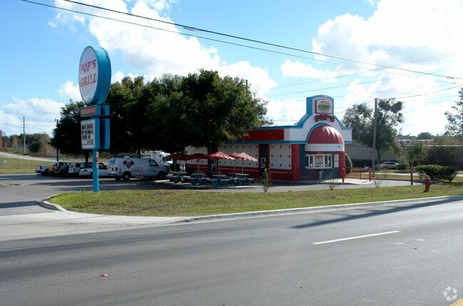
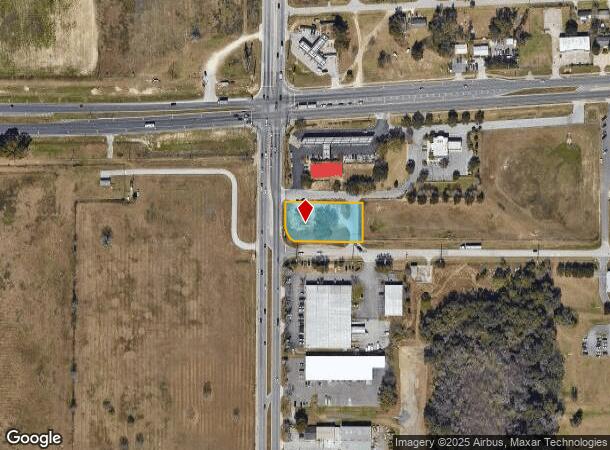
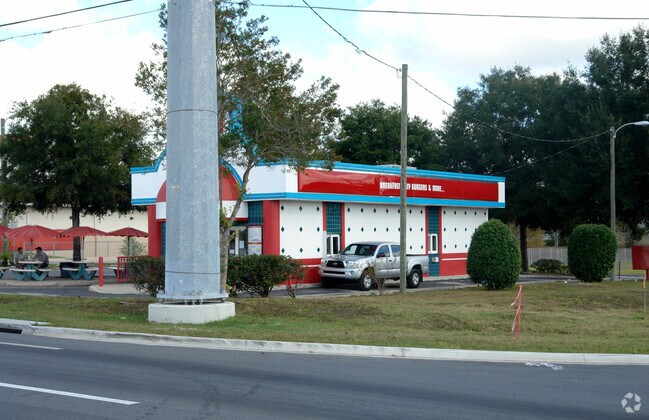
Property Record
101 Sw 60Th Ave, Ocala, FL 34474
NEARBY LISTINGS FOR SALE OR LEASE
Property Detail
101 Sw 60Th Ave
Ocala, FL
Ocala Airport Commerce Center
2318-001-002
SEC 16 TWP 15 RGE 21 PLAT BOOK U PAGE 074 OCALA AIRPORT COMMERCE CENTER THE S 134 FT OF THE W 265 FT OF LOT 2 BLK A
Commercialacreage
Marion
X
Florida
12083C0512E
2
2024
0.80 AC
2024
Greater Ocala
002504
Ocala
1,406 SF
DEMOGRAPHICS near 101 Sw 60Th Ave
1 Mile
3 Mile
5 Mile
2024 Total Population
1,324
20,001
50,284
2029 Population
1,511
22,528
56,992
Pop Growth 2024-2029
+ 14.12%
+ 12.63%
+ 13.34%
Average Age
36
44
43
2024 Total Households
443
8,035
20,665
HH Growth 2024-2029
+ 14.00%
+ 12.82%
+ 13.39%
Median Household Inc
$10,631
$59,386
$51,515
Avg Household Size
2.50
2.20
2.30
2024 Avg HH Vehicles
1.00
1.00
2.00
Median Home Value
$96,261
$219,166
$204,116
Median Year Built
1984
1994
1992
Nearby Places
- Restaurants
- Banks
- Shops
- Fitness
- Groceries
Nearby Properties
Address
Land Use
TOTAL SIZE
Lot Size
Zoning
Address
Land Use
TOTAL SIZE
Lot Size
Zoning
794,310 SF
270.60 AC
A1
Address
Land Use
TOTAL SIZE
Lot Size
Zoning
2,015,469 SF
169.30 AC
M1
Address
Land Use
TOTAL SIZE
Lot Size
Zoning
704,765 SF
71.04 AC
GU
Address
Land Use
TOTAL SIZE
Lot Size
Zoning
493,261 SF
126.01 AC
R3
Address
Land Use
TOTAL SIZE
Lot Size
Zoning
1,085,670 SF
89.70 AC
M1
Address
Land Use
TOTAL SIZE
Lot Size
Zoning
164,363 SF
16.51 AC
R3
Address
Land Use
TOTAL SIZE
Lot Size
Zoning
322,193 SF
70.13 AC
INST
Address
Land Use
TOTAL SIZE
Lot Size
Zoning
152,355 SF
973.50 AC
GU
Address
Land Use
TOTAL SIZE
Lot Size
Zoning
403,023 SF
47.47 AC
M1
Address
Land Use
TOTAL SIZE
Lot Size
Zoning
421,243 SF
51.48 AC
M2
Address
Land Use
TOTAL SIZE
Lot Size
Zoning
65,570 SF
18.96 AC
PD
Address
Land Use
TOTAL SIZE
Lot Size
Zoning
60,816 SF
13.67 AC
PD
Address
Land Use
TOTAL SIZE
Lot Size
Zoning
604,920 SF
42.92 AC
M1
Address
Land Use
TOTAL SIZE
Lot Size
Zoning
194,275 SF
13.43 AC
M1
Address
Land Use
TOTAL SIZE
Lot Size
Zoning
392,617 SF
23.83 AC
M1
Address
Land Use
TOTAL SIZE
Lot Size
Zoning
113,501 SF
68.56 AC
INST
Address
Land Use
TOTAL SIZE
Lot Size
Zoning
482,618 SF
34.54 AC
M2
Address
Land Use
TOTAL SIZE
Lot Size
Zoning
91,872 SF
216.43 AC
M1
Address
Land Use
TOTAL SIZE
Lot Size
Zoning
364,404 SF
31.83 AC
M1
Address
Land Use
TOTAL SIZE
Lot Size
Zoning
360,450 SF
20 AC
M1
Address
Land Use
TOTAL SIZE
Lot Size
Zoning
65,882 SF
13.34 AC
R3
Address
Land Use
TOTAL SIZE
Lot Size
Zoning
146,091 SF
43.91 AC
M1
Address
Land Use
TOTAL SIZE
Lot Size
Zoning
9,854 SF
55.14 AC
B2
Address
Land Use
TOTAL SIZE
Lot Size
Zoning
39,411 SF
3.35 AC
B2
Address
Land Use
TOTAL SIZE
Lot Size
Zoning
265,793 SF
30 AC
M1
Address
Land Use
TOTAL SIZE
Lot Size
Zoning
23,441 SF
2.33 AC
B2
Address
Land Use
TOTAL SIZE
Lot Size
Zoning
79,199 SF
13.54 AC
B2
Address
Land Use
TOTAL SIZE
Lot Size
Zoning
160,796 SF
25.59 AC
M2
Address
Land Use
TOTAL SIZE
Lot Size
Zoning
201,556 SF
16.50 AC
M1
Address
Land Use
TOTAL SIZE
Lot Size
Zoning
153,456 SF
16.98 AC
M2
The World's #1 Commercial Real Estate Marketplace
Connect with us
© 2025 CoStar Group
The information above has been obtained from sources believed reliable. While we do not doubt its accuracy we have not verified it and make no guarantee, warranty or representation about it. It is your responsibility to independently confirm its accuracy and completeness. Any projections, opinions, assumptions, or estimates used are for example only and do not represent the current or future performance of the property. The value of this transaction to you depends on tax and other factors which should be evaluated by your tax, financial, and legal advisors. You and your advisors should conduct a careful, independent investigation of the property to determine to your satisfaction the suitability of the property for your needs.