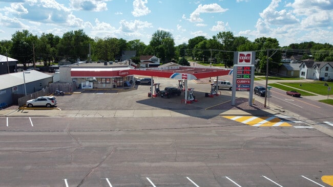
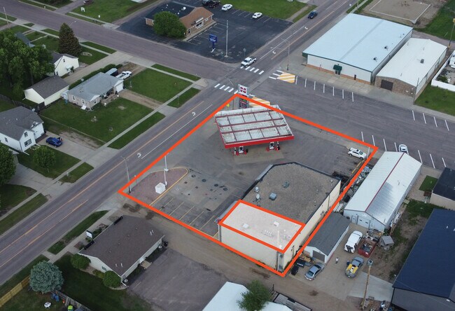
Property Record
101 W 1St St W, Tea, SD 57064

Current Lease Availabilities
Property Detail
101 W 1St St W
Sioux Falls, SD-MN
TEA-BYRONS ADD-LOTS 1-2 & 3 - BLK 1
240.10.01.002
LINCOLN
Commercialnec
South Dakota
MUNICIPALI
1-3
B and X Area of moderate flood hazard, usually the area between the limits of the 100-year and 500-year floods.
0.45 AC
2024
Sioux Falls
2024
Other Market Areas
010115
NEARBY LISTINGS FOR SALE OR LEASE
DEMOGRAPHICS near 101 W 1St St W
1 mile
3 mile
5 mile
2025 Total Population
5,555
8,822
44,573
2030 Population
6,323
10,039
48,916
Pop Growth 2025-2030
+ 13.83%
+ 13.80%
+ 9.74%
Average Age
33
34
36
2025 Total Households
1,901
3,003
17,019
HH Growth 2025-2030
+ 14.10%
+ 14.05%
+ 9.99%
Median Household Inc
$108,426
$112,426
$91,156
Avg Household Size
2.90
2.90
2.60
2025 Avg HH Vehicles
3.00
3.00
2.00
Median Home Value
$333,410
$360,517
$328,474
Median Year Built
2005
2006
2005
Nearby Places
Map Layers
Map Styles
 Street
 Aerial
Transit
 Traffic
 Biking
Places
Listings with unknown addresses are not visible on the map
- Restaurants
- Banks
- Shops
- Fitness
- Groceries
PUBLIC TRANSPORTATION
AIRPORT
Joe Foss Field
Drive
Walk
Distance
Joe Foss Field
34 min
14.9 mi
Nearby Properties
Address
Land Use
TOTAL SIZE
Lot Size
Zoning
Address
Land Use
TOTAL SIZE
Lot Size
Zoning
8.65 AC
MUNICIPALI
Address
Land Use
TOTAL SIZE
Lot Size
Zoning
11.80 AC
I-1 LIGHT
Address
Land Use
TOTAL SIZE
Lot Size
Zoning
8.28 AC
MUNICIPALI
Address
Land Use
TOTAL SIZE
Lot Size
Zoning
3.56 AC
MUNICIPALI
Address
Land Use
TOTAL SIZE
Lot Size
Zoning
4.62 AC
MUNICIPALI
Address
Land Use
TOTAL SIZE
Lot Size
Zoning
5.14 AC
MUNICIPALI
Address
Land Use
TOTAL SIZE
Lot Size
Zoning
2.50 AC
MUNICIPALI
Address
Land Use
TOTAL SIZE
Lot Size
Zoning
2.48 AC
MUNICIPALI
Address
Land Use
TOTAL SIZE
Lot Size
Zoning
4.04 AC
C COMMERCI
Address
Land Use
TOTAL SIZE
Lot Size
Zoning
2.47 AC
MUNICIPALI
Address
Land Use
TOTAL SIZE
Lot Size
Zoning
1.56 AC
MUNICIPALI
Address
Land Use
TOTAL SIZE
Lot Size
Zoning
5.43 AC
MUNICIPALI
Address
Land Use
TOTAL SIZE
Lot Size
Zoning
2.11 AC
MUNICIPALI
Address
Land Use
TOTAL SIZE
Lot Size
Zoning
3.02 AC
MUNICIPALI
Address
Land Use
TOTAL SIZE
Lot Size
Zoning
9.50 AC
MUNICIPALI
Address
Land Use
TOTAL SIZE
Lot Size
Zoning
7.60 AC
MUNICIPALI
Address
Land Use
TOTAL SIZE
Lot Size
Zoning
4.72 AC
MUNICIPALI
Address
Land Use
TOTAL SIZE
Lot Size
Zoning
14.33 AC
MUNICIPALI
Address
Land Use
TOTAL SIZE
Lot Size
Zoning
3.18 AC
MUNICIPALI
Address
Land Use
TOTAL SIZE
Lot Size
Zoning
4.68 AC
C COMMERCI
Address
Land Use
TOTAL SIZE
Lot Size
Zoning
2.09 AC
MUNICIPALI
Address
Land Use
TOTAL SIZE
Lot Size
Zoning
2.08 AC
I-1 LIGHT
Address
Land Use
TOTAL SIZE
Lot Size
Zoning
3.04 AC
I-1 LIGHT
Address
Land Use
TOTAL SIZE
Lot Size
Zoning
2.33 AC
MUNICIPALI
Address
Land Use
TOTAL SIZE
Lot Size
Zoning
14.59 AC
MUNICIPALI
Address
Land Use
TOTAL SIZE
Lot Size
Zoning
2.39 AC
MUNICIPALI
Address
Land Use
TOTAL SIZE
Lot Size
Zoning
4.08 AC
MUNICIPALI
Address
Land Use
TOTAL SIZE
Lot Size
Zoning
1.80 AC
MUNICIPALI
Address
Land Use
TOTAL SIZE
Lot Size
Zoning
1.19 AC
MUNICIPALI
Address
Land Use
TOTAL SIZE
Lot Size
Zoning
1.94 AC
C COMMERCI
The World's #1 Commercial Real Estate Marketplace
Connect with us
© 2026 CoStar Group
The information above has been obtained from sources believed reliable. While we do not doubt its accuracy we have not verified it and make no guarantee, warranty or representation about it. It is your responsibility to independently confirm its accuracy and completeness. Any projections, opinions, assumptions, or estimates used are for example only and do not represent the current or future performance of the property. The value of this transaction to you depends on tax and other factors which should be evaluated by your tax, financial, and legal advisors. You and your advisors should conduct a careful, independent investigation of the property to determine to your satisfaction the suitability of the property for your needs.