Property Record
101 W 3Rd St, Chaska, MN 55318


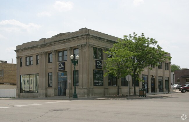

Property Detail
101 W 3Rd St
30.6890010
Carver
Officebuilding
Minnesota
B and X Area of moderate flood hazard, usually the area between the limits of the 100-year and 500-year floods.
1
2026
0.20 AC
2025
Carver County Outlying
091002
Minneapolis/St Paul
5,394 SF
Minneapolis-St. Paul-Bloomington, MN-WI
NEARBY LISTINGS FOR SALE OR LEASE
DEMOGRAPHICS near 101 W 3Rd St
1 mile
3 mile
5 mile
2025 Total Population
5,425
33,948
72,729
2030 Population
5,651
35,446
75,578
Pop Growth 2025-2030
+ 4.17%
+ 4.41%
+ 3.92%
Average Age
39
38
39
2025 Total Households
2,194
12,396
25,999
HH Growth 2025-2030
+ 4.24%
+ 4.46%
+ 4.01%
Median Household Inc
$86,426
$112,225
$115,687
Avg Household Size
2.40
2.70
2.70
2025 Avg HH Vehicles
2.00
2.00
2.00
Median Home Value
$337,292
$374,320
$410,650
Median Year Built
1987
1995
1997
Nearby Places
Map Layers
Map Styles
 Street
 Aerial
Layers
 Traffic
 Biking
Places
Listings with unknown addresses are not visible on the map
- Restaurants
- Banks
- Shops
- Fitness
- Groceries
PUBLIC TRANSPORTATION
AIRPORT
Minneapolis-St Paul International/Wold-Chamberlain
Drive
Walk
Distance
Minneapolis-St Paul International/Wold-Chamberlain
32 min
23.6 mi
Freight Ports
Port Milwaukee
Drive
Walk
Distance
Port Milwaukee
401 min
360.8 mi
Nearby Properties
Address
Land Use
TOTAL SIZE
Lot Size
Zoning
Address
Land Use
TOTAL SIZE
Lot Size
Zoning
209,623 SF
72.81 AC
Address
Land Use
TOTAL SIZE
Lot Size
Zoning
20,086 SF
12.99 AC
Address
Land Use
TOTAL SIZE
Lot Size
Zoning
Address
Land Use
TOTAL SIZE
Lot Size
Zoning
44,611 SF
9.75 AC
Address
Land Use
TOTAL SIZE
Lot Size
Zoning
20,586 SF
19.34 AC
Address
Land Use
TOTAL SIZE
Lot Size
Zoning
5.71 AC
Address
Land Use
TOTAL SIZE
Lot Size
Zoning
254,602 SF
18.19 AC
Address
Land Use
TOTAL SIZE
Lot Size
Zoning
57,769 SF
62.10 AC
Address
Land Use
TOTAL SIZE
Lot Size
Zoning
26.05 AC
Address
Land Use
TOTAL SIZE
Lot Size
Zoning
73,937 SF
23.89 AC
Address
Land Use
TOTAL SIZE
Lot Size
Zoning
20.18 AC
Address
Land Use
TOTAL SIZE
Lot Size
Zoning
65,038 SF
6.72 AC
Address
Land Use
TOTAL SIZE
Lot Size
Zoning
10,038 SF
12.21 AC
Address
Land Use
TOTAL SIZE
Lot Size
Zoning
18,980 SF
2.77 AC
Address
Land Use
TOTAL SIZE
Lot Size
Zoning
10.40 AC
Address
Land Use
TOTAL SIZE
Lot Size
Zoning
17.50 AC
Address
Land Use
TOTAL SIZE
Lot Size
Zoning
Address
Land Use
TOTAL SIZE
Lot Size
Zoning
20.79 AC
Address
Land Use
TOTAL SIZE
Lot Size
Zoning
33,982 SF
0.38 AC
Address
Land Use
TOTAL SIZE
Lot Size
Zoning
183,323 SF
16.30 AC
Address
Land Use
TOTAL SIZE
Lot Size
Zoning
128,456 SF
15.85 AC
Address
Land Use
TOTAL SIZE
Lot Size
Zoning
3.75 AC
Address
Land Use
TOTAL SIZE
Lot Size
Zoning
255,630 SF
27.07 AC
Address
Land Use
TOTAL SIZE
Lot Size
Zoning
59,724 SF
10.28 AC
Address
Land Use
TOTAL SIZE
Lot Size
Zoning
61,267 SF
4.59 AC
Address
Land Use
TOTAL SIZE
Lot Size
Zoning
6.32 AC
Address
Land Use
TOTAL SIZE
Lot Size
Zoning
24,768 SF
7.30 AC
Address
Land Use
TOTAL SIZE
Lot Size
Zoning
119.59 AC
I-2
Address
Land Use
TOTAL SIZE
Lot Size
Zoning
29,672 SF
7.79 AC
The World's #1 Commercial Real Estate Marketplace
Connect with us
© 2026 CoStar Group
The information above has been obtained from sources believed reliable. While we do not doubt its accuracy we have not verified it and make no guarantee, warranty or representation about it. It is your responsibility to independently confirm its accuracy and completeness. Any projections, opinions, assumptions, or estimates used are for example only and do not represent the current or future performance of the property. The value of this transaction to you depends on tax and other factors which should be evaluated by your tax, financial, and legal advisors. You and your advisors should conduct a careful, independent investigation of the property to determine to your satisfaction the suitability of the property for your needs.