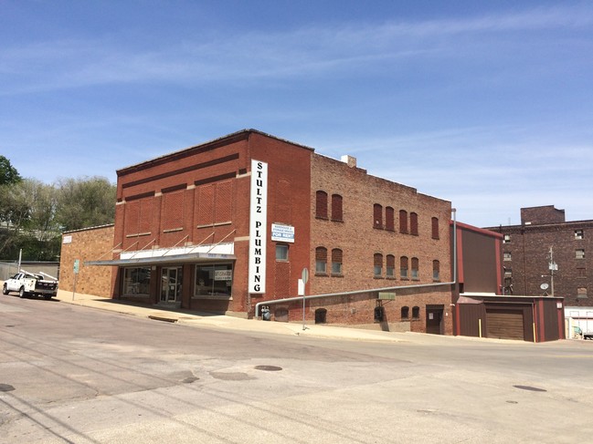
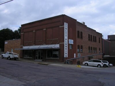
Property Record
101 W 3Rd St, Sioux City, IA 51103

NEARBY LISTINGS FOR SALE OR LEASE
Property Detail
101 W 3Rd St
894729436030
Sioux City
Storesoffices
SIOUX CITY ADDN AUD PLAT BLKS 44 & 45 & PT BLK 39 PT TAX LOT 1 (EX RR ROW) AND (EX PT BEG AT SELY COR THNC NE 67.07 FT, THNC
X
Woodbury
19193C0181E
Iowa
2024
1,7-9
2025
0.56 AC
003600
Other Market Areas
16,968 SF
Sioux City, IA-NE-SD
DEMOGRAPHICS near 101 W 3Rd St
1 Mile
3 Mile
5 Mile
2024 Total Population
11,758
65,362
103,068
2029 Population
11,846
64,787
102,564
Pop Growth 2024-2029
+ 0.75%
(0.88%)
(0.49%)
Average Age
36
36
37
2024 Total Households
4,386
23,544
38,105
HH Growth 2024-2029
+ 1.14%
(0.80%)
(0.44%)
Median Household Inc
$38,237
$52,853
$58,229
Avg Household Size
2.40
2.60
2.60
2024 Avg HH Vehicles
1.00
2.00
2.00
Median Home Value
$78,196
$136,459
$150,934
Median Year Built
1946
1952
1958
Nearby Places
Map Layers
Map Styles
 Street
 Aerial
- Restaurants
- Banks
- Shops
- Fitness
- Groceries
SALE & LEASE HISTORY
LISTING DATE
SALE/LEASE

Sep 23, 2016
For Sale
Dec 27, 2018
For Sale
Nearby Properties
Address
Land Use
TOTAL SIZE
Lot Size
Zoning
Address
Land Use
TOTAL SIZE
Lot Size
Zoning
452,648 SF
2.84 AC
Address
Land Use
TOTAL SIZE
Lot Size
Zoning
361,136 SF
2.01 AC
Address
Land Use
TOTAL SIZE
Lot Size
Zoning
293,480 SF
104.66 AC
Address
Land Use
TOTAL SIZE
Lot Size
Zoning
264,268 SF
10.74 AC
Address
Land Use
TOTAL SIZE
Lot Size
Zoning
188,642 SF
7.19 AC
Address
Land Use
TOTAL SIZE
Lot Size
Zoning
1,440 SF
2.80 AC
Address
Land Use
TOTAL SIZE
Lot Size
Zoning
135,076 SF
4.36 AC
Address
Land Use
TOTAL SIZE
Lot Size
Zoning
10,056 SF
67.70 AC
Address
Land Use
TOTAL SIZE
Lot Size
Zoning
167,326 SF
6.21 AC
Address
Land Use
TOTAL SIZE
Lot Size
Zoning
157,234 SF
0.31 AC
Address
Land Use
TOTAL SIZE
Lot Size
Zoning
109,332 SF
27.49 AC
Address
Land Use
TOTAL SIZE
Lot Size
Zoning
200,862 SF
8.95 AC
MULTI-FAMI
Address
Land Use
TOTAL SIZE
Lot Size
Zoning
52,228 SF
1.38 AC
Address
Land Use
TOTAL SIZE
Lot Size
Zoning
24,362 SF
14.87 AC
Address
Land Use
TOTAL SIZE
Lot Size
Zoning
89,016 SF
3.77 AC
Address
Land Use
TOTAL SIZE
Lot Size
Zoning
95,714 SF
1.05 AC
Address
Land Use
TOTAL SIZE
Lot Size
Zoning
3,600 SF
25.76 AC
Address
Land Use
TOTAL SIZE
Lot Size
Zoning
3,482 SF
22.10 AC
Address
Land Use
TOTAL SIZE
Lot Size
Zoning
82,170 SF
25.21 AC
Address
Land Use
TOTAL SIZE
Lot Size
Zoning
80,729 SF
2.92 AC
Address
Land Use
TOTAL SIZE
Lot Size
Zoning
4,560 SF
32.79 AC
Address
Land Use
TOTAL SIZE
Lot Size
Zoning
86,825 SF
1.07 AC
Address
Land Use
TOTAL SIZE
Lot Size
Zoning
110,212 SF
0.22 AC
Address
Land Use
TOTAL SIZE
Lot Size
Zoning
85,409 SF
1.18 AC
Address
Land Use
TOTAL SIZE
Lot Size
Zoning
27,820 SF
13.27 AC
Address
Land Use
TOTAL SIZE
Lot Size
Zoning
87,459 SF
4.85 AC
Address
Land Use
TOTAL SIZE
Lot Size
Zoning
161,680 SF
1.91 AC
The World's #1 Commercial Real Estate Marketplace
Connect with us
© 2025 CoStar Group
The information above has been obtained from sources believed reliable. While we do not doubt its accuracy we have not verified it and make no guarantee, warranty or representation about it. It is your responsibility to independently confirm its accuracy and completeness. Any projections, opinions, assumptions, or estimates used are for example only and do not represent the current or future performance of the property. The value of this transaction to you depends on tax and other factors which should be evaluated by your tax, financial, and legal advisors. You and your advisors should conduct a careful, independent investigation of the property to determine to your satisfaction the suitability of the property for your needs.