Property Record
101 W 61St Ave, Hobart, IN 46342
NEARBY LISTINGS FOR SALE OR LEASE
Property Detail
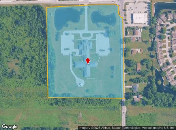
101 W 61St Ave
45-13-06-476-002.000-018
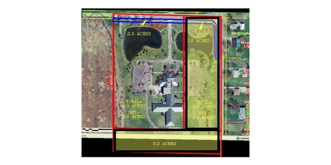
PT. SE1/4 SE1/4 S.6 T.35 R.7 EX. PT. IN R/W 16.911 AC
Officebuilding
Lake
X
Indiana
18089C0169E
1
2024
16.91 AC
2025
Indiana
042000
Chicago
34,345 SF
Chicago-Naperville-Elgin, IL-IN-WI
DEMOGRAPHICS near 101 W 61St Ave
1 Mile
3 Mile
5 Mile
2024 Total Population
4,670
26,330
86,866
2029 Population
4,636
26,286
87,927
Pop Growth 2024-2029
(0.73%)
(0.17%)
+ 1.22%
Average Age
45
41
40
2024 Total Households
2,025
10,456
33,812
HH Growth 2024-2029
(0.69%)
(0.18%)
+ 1.17%
Median Household Inc
$68,534
$69,759
$54,112
Avg Household Size
2.30
2.50
2.50
2024 Avg HH Vehicles
2.00
2.00
2.00
Median Home Value
$205,354
$195,261
$153,556
Median Year Built
1992
1972
1966
Nearby Places
Map Layers
Map Styles
 Street
 Aerial
- Restaurants
- Banks
- Shops
- Fitness
- Groceries
PUBLIC TRANSPORTATION
COMMUTER RAIL
Miller (Gary) Station (South Shore Line - Northern Indiana Commuter Transportation District (South Shore Line))
DRIVE
WALK
Distance
Miller (Gary) Station (South Shore Line - Northern Indiana Commuter Transportation District (South Shore Line))
19 min
7.5 mi
Freight Ports
Port Milwaukee
DRIVE
WALK
Distance
Port Milwaukee
165 min
126.7 mi
Nearby Properties
Address
Land Use
TOTAL SIZE
Lot Size
Zoning
Address
Land Use
TOTAL SIZE
Lot Size
Zoning
552,100 SF
49.14 AC
Address
Land Use
TOTAL SIZE
Lot Size
Zoning
655,916 SF
46.27 AC
Address
Land Use
TOTAL SIZE
Lot Size
Zoning
590,274 SF
48.18 AC
Address
Land Use
TOTAL SIZE
Lot Size
Zoning
862,805 SF
36.93 AC
R33
Address
Land Use
TOTAL SIZE
Lot Size
Zoning
623,283 SF
44.38 AC
Address
Land Use
TOTAL SIZE
Lot Size
Zoning
359,024 SF
43 AC
Address
Land Use
TOTAL SIZE
Lot Size
Zoning
83,904 SF
15.47 AC
Address
Land Use
TOTAL SIZE
Lot Size
Zoning
159,954 SF
8.49 AC
Address
Land Use
TOTAL SIZE
Lot Size
Zoning
126,603 SF
8.81 AC
Address
Land Use
TOTAL SIZE
Lot Size
Zoning
212,330 SF
10.70 AC
Address
Land Use
TOTAL SIZE
Lot Size
Zoning
102,255 SF
3.96 AC
R33
Address
Land Use
TOTAL SIZE
Lot Size
Zoning
159,117 SF
14.85 AC
R33
Address
Land Use
TOTAL SIZE
Lot Size
Zoning
150,000 SF
9.02 AC
R3
Address
Land Use
TOTAL SIZE
Lot Size
Zoning
100,052 SF
8.19 AC
Address
Land Use
TOTAL SIZE
Lot Size
Zoning
90,060 SF
8.10 AC
Address
Land Use
TOTAL SIZE
Lot Size
Zoning
38,071 SF
6.01 AC
Address
Land Use
TOTAL SIZE
Lot Size
Zoning
41,200 SF
8.60 AC
Address
Land Use
TOTAL SIZE
Lot Size
Zoning
100,690 SF
15.44 AC
Address
Land Use
TOTAL SIZE
Lot Size
Zoning
101,760 SF
5.44 AC
R33
Address
Land Use
TOTAL SIZE
Lot Size
Zoning
105,865 SF
9.09 AC
Address
Land Use
TOTAL SIZE
Lot Size
Zoning
19,896 SF
5 AC
Address
Land Use
TOTAL SIZE
Lot Size
Zoning
48,228 SF
4.53 AC
Address
Land Use
TOTAL SIZE
Lot Size
Zoning
41,831 SF
3.36 AC
R33
Address
Land Use
TOTAL SIZE
Lot Size
Zoning
89,760 SF
5.67 AC
R33
Address
Land Use
TOTAL SIZE
Lot Size
Zoning
16,038 SF
2.30 AC
Address
Land Use
TOTAL SIZE
Lot Size
Zoning
16,300 SF
2.31 AC
Address
Land Use
TOTAL SIZE
Lot Size
Zoning
91,066 SF
8.28 AC
R33
Address
Land Use
TOTAL SIZE
Lot Size
Zoning
66,390 SF
18.58 AC
Address
Land Use
TOTAL SIZE
Lot Size
Zoning
52,442 SF
4.48 AC
Address
Land Use
TOTAL SIZE
Lot Size
Zoning
29,251 SF
25.96 AC
The World's #1 Commercial Real Estate Marketplace
Connect with us
© 2026 CoStar Group
The information above has been obtained from sources believed reliable. While we do not doubt its accuracy we have not verified it and make no guarantee, warranty or representation about it. It is your responsibility to independently confirm its accuracy and completeness. Any projections, opinions, assumptions, or estimates used are for example only and do not represent the current or future performance of the property. The value of this transaction to you depends on tax and other factors which should be evaluated by your tax, financial, and legal advisors. You and your advisors should conduct a careful, independent investigation of the property to determine to your satisfaction the suitability of the property for your needs.