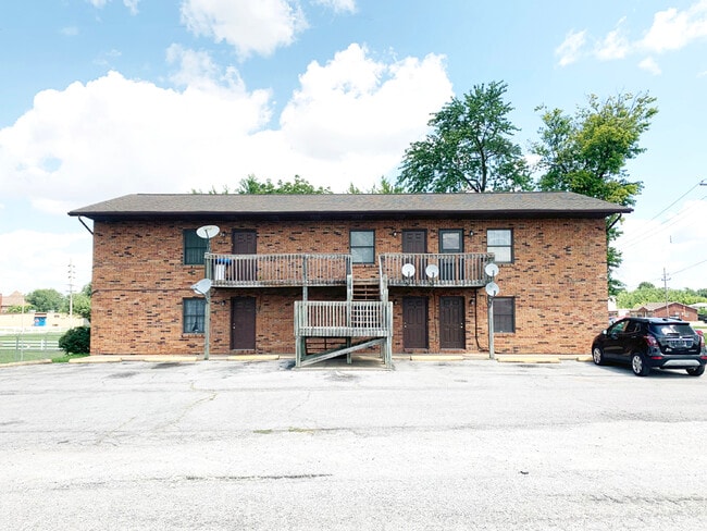
Property Record
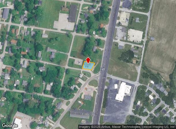
101 W Water St, Cahokia, IL 62206
NEARBY LISTINGS FOR SALE OR LEASE
Property Detail
101 W Water St
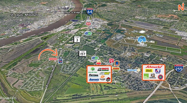
St. Louis
Cahokia Village, Hilgards Plat
St. Louis, MO-IL
CAHOKIA VILLAGE, HILGARDS PLAT LOT/SEC-159-BLK/RG-1 SLY 1/2 EXC PT OFF E E SIDE FOR HWY A02721974
06-03.0-224-008
St. Clair
Apartment
Illinois
2024
159
2024
0.19 AC
502602
East Saint Louis
2,310 SF
DEMOGRAPHICS near 101 W Water St
1 Mile
3 Mile
5 Mile
2024 Total Population
5,646
40,667
156,459
2029 Population
5,665
39,426
148,777
Pop Growth 2024-2029
+ 0.34%
(3.05%)
(4.91%)
Average Age
35
37
38
2024 Total Households
1,998
16,983
72,219
HH Growth 2024-2029
+ 0.40%
(3.31%)
(5.05%)
Median Household Inc
$32,848
$42,087
$50,580
Avg Household Size
2.70
2.30
2.10
2024 Avg HH Vehicles
1.00
1.00
1.00
Median Home Value
$56,219
$97,298
$154,064
Median Year Built
1958
1948
1947
Nearby Places
Map Layers
Map Styles
 Street
 Aerial
- Restaurants
- Banks
- Shops
- Fitness
- Groceries
PUBLIC TRANSPORTATION
COMMUTER RAIL
Stadium (Lambert Airport Shiloh-Scott - St. Louis MetroLink (MetroLink), Shrewsbury-Lansdowne I-44 Emerson Park - St. Louis MetroLink (MetroLink))
DRIVE
WALK
Distance
Stadium (Lambert Airport Shiloh-Scott - St. Louis MetroLink (MetroLink), Shrewsbury-Lansdowne I-44 Emerson Park - St. Louis MetroLink (MetroLink))
9 min
5.3 mi
Civic Center (Lambert Airport Shiloh-Scott - St. Louis MetroLink (MetroLink), Shrewsbury-Lansdowne I-44 Emerson Park - St. Louis MetroLink (MetroLink))
DRIVE
WALK
Distance
Civic Center (Lambert Airport Shiloh-Scott - St. Louis MetroLink (MetroLink), Shrewsbury-Lansdowne I-44 Emerson Park - St. Louis MetroLink (MetroLink))
10 min
5.7 mi
AIRPORT
St Louis Lambert International
DRIVE
WALK
Distance
St Louis Lambert International
30 min
19.4 mi
Scott AFB/Midamerica St Louis
DRIVE
WALK
Distance
Scott AFB/Midamerica St Louis
42 min
27.3 mi
Freight Ports
Port Milwaukee
DRIVE
WALK
Distance
Port Milwaukee
421 min
372.0 mi
SALE & LEASE HISTORY
LISTING DATE
SALE/LEASE

Aug 31, 2021
For Sale
Nearby Properties
Address
Land Use
TOTAL SIZE
Lot Size
Zoning
Address
Land Use
TOTAL SIZE
Lot Size
Zoning
467,800 SF
1.30 AC
K
Address
Land Use
TOTAL SIZE
Lot Size
Zoning
69,100 SF
20.69 AC
Address
Land Use
TOTAL SIZE
Lot Size
Zoning
114,000 SF
1.25 AC
J
Address
Land Use
TOTAL SIZE
Lot Size
Zoning
12,308 SF
18.44 AC
Address
Land Use
TOTAL SIZE
Lot Size
Zoning
2,550 SF
16.69 AC
Address
Land Use
TOTAL SIZE
Lot Size
Zoning
54,790 SF
0.87 AC
B
Address
Land Use
TOTAL SIZE
Lot Size
Zoning
273 SF
232.96 AC
Address
Land Use
TOTAL SIZE
Lot Size
Zoning
Address
Land Use
TOTAL SIZE
Lot Size
Zoning
Address
Land Use
TOTAL SIZE
Lot Size
Zoning
Address
Land Use
TOTAL SIZE
Lot Size
Zoning
353,728 SF
10.67 AC
K
Address
Land Use
TOTAL SIZE
Lot Size
Zoning
127,000 SF
6.75 AC
J
Address
Land Use
TOTAL SIZE
Lot Size
Zoning
20,140 SF
20.42 AC
Address
Land Use
TOTAL SIZE
Lot Size
Zoning
28.07 AC
Address
Land Use
TOTAL SIZE
Lot Size
Zoning
50,060 SF
20.10 AC
K
Address
Land Use
TOTAL SIZE
Lot Size
Zoning
264,575 SF
1.50 AC
K
Address
Land Use
TOTAL SIZE
Lot Size
Zoning
157,868 SF
12.01 AC
Address
Land Use
TOTAL SIZE
Lot Size
Zoning
14.47 AC
C
Address
Land Use
TOTAL SIZE
Lot Size
Zoning
197,690 SF
32.20 AC
Address
Land Use
TOTAL SIZE
Lot Size
Zoning
118,030 SF
6.78 AC
Address
Land Use
TOTAL SIZE
Lot Size
Zoning
72,100 SF
6.34 AC
FB
Address
Land Use
TOTAL SIZE
Lot Size
Zoning
153,672 SF
8.20 AC
K
Address
Land Use
TOTAL SIZE
Lot Size
Zoning
80,000 SF
71.47 AC
Address
Land Use
TOTAL SIZE
Lot Size
Zoning
15,323 SF
10.38 AC
Address
Land Use
TOTAL SIZE
Lot Size
Zoning
297,280 SF
5.04 AC
K
Address
Land Use
TOTAL SIZE
Lot Size
Zoning
13.37 AC
C
Address
Land Use
TOTAL SIZE
Lot Size
Zoning
41,264 SF
24 AC
K
Address
Land Use
TOTAL SIZE
Lot Size
Zoning
151,770 SF
7.73 AC
K
Address
Land Use
TOTAL SIZE
Lot Size
Zoning
119,539 SF
8.40 AC
B
Address
Land Use
TOTAL SIZE
Lot Size
Zoning
9,016 SF
25.15 AC
The World's #1 Commercial Real Estate Marketplace
Connect with us
© 2025 CoStar Group
The information above has been obtained from sources believed reliable. While we do not doubt its accuracy we have not verified it and make no guarantee, warranty or representation about it. It is your responsibility to independently confirm its accuracy and completeness. Any projections, opinions, assumptions, or estimates used are for example only and do not represent the current or future performance of the property. The value of this transaction to you depends on tax and other factors which should be evaluated by your tax, financial, and legal advisors. You and your advisors should conduct a careful, independent investigation of the property to determine to your satisfaction the suitability of the property for your needs.