Property Record
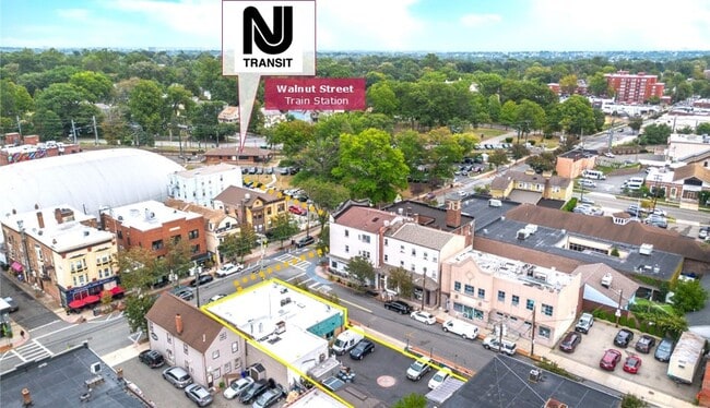
101 Walnut St, Montclair, NJ 07042


This Property Is For Sale
Property Detail
101 Walnut St
13-03203-0000-00019
57X100 IRR
Recreationalentertainmentgeneral
Essex
C2
New Jersey
AE The base floodplain where base flood elevations are provided. AE Zones are now used on new format FIRMs instead of A1-A30 Zones.
19
2024
0.13 AC
2025
Urban Essex
016600
Northern New Jersey
2,716 SF
Newark, NJ
NEARBY LISTINGS FOR SALE OR LEASE
DEMOGRAPHICS near 101 Walnut St
1 mile
3 mile
5 mile
2025 Total Population
27,265
207,709
644,243
2030 Population
28,622
216,902
668,738
Pop Growth 2025-2030
+ 4.98%
+ 4.43%
+ 3.80%
Average Age
40
41
40
2025 Total Households
11,333
79,938
240,734
HH Growth 2025-2030
+ 5.15%
+ 4.60%
+ 4.00%
Median Household Inc
$147,810
$117,787
$92,139
Avg Household Size
2.30
2.50
2.60
2025 Avg HH Vehicles
2.00
2.00
2.00
Median Home Value
$759,099
$549,381
$497,737
Median Year Built
1948
1951
1955
Nearby Places
Map Layers
Map Styles
 Street
 Aerial
Transit
 Traffic
 Biking
Places
Listings with unknown addresses are not visible on the map
- Restaurants
- Banks
- Shops
- Fitness
- Groceries
PUBLIC TRANSPORTATION
TRANSIT/SUBWAY
Walnut Street (Montclair-Boonton Line - NJ Transit Commuter Rail (NJ Transit))
Drive
Walk
Distance
Walnut Street (Montclair-Boonton Line - NJ Transit Commuter Rail (NJ Transit))
1 min
2 min
0.1 mi
Bay Street (Montclair-Boonton Line - NJ Transit Commuter Rail (NJ Transit))
Drive
Walk
Distance
Bay Street (Montclair-Boonton Line - NJ Transit Commuter Rail (NJ Transit))
3 min
16 min
0.8 mi
COMMUTER RAIL
Walnut Street (Montclair-Boonton Line - NJ Transit Commuter Rail (NJ Transit))
Drive
Walk
Distance
Walnut Street (Montclair-Boonton Line - NJ Transit Commuter Rail (NJ Transit))
1 min
2 min
0.1 mi
Bay Street (Montclair-Boonton Line - NJ Transit Commuter Rail (NJ Transit))
Drive
Walk
Distance
Bay Street (Montclair-Boonton Line - NJ Transit Commuter Rail (NJ Transit))
3 min
16 min
0.8 mi
AIRPORT
Newark Liberty International
Drive
Walk
Distance
Newark Liberty International
24 min
13.6 mi
LaGuardia
Drive
Walk
Distance
LaGuardia
46 min
24.8 mi
John F Kennedy International
Drive
Walk
Distance
John F Kennedy International
56 min
32.9 mi
Freight Ports
Maher Terminal
Drive
Walk
Distance
Maher Terminal
27 min
14.5 mi
The World's #1 Commercial Real Estate Marketplace
Connect with us
© 2026 CoStar Group
The information above has been obtained from sources believed reliable. While we do not doubt its accuracy we have not verified it and make no guarantee, warranty or representation about it. It is your responsibility to independently confirm its accuracy and completeness. Any projections, opinions, assumptions, or estimates used are for example only and do not represent the current or future performance of the property. The value of this transaction to you depends on tax and other factors which should be evaluated by your tax, financial, and legal advisors. You and your advisors should conduct a careful, independent investigation of the property to determine to your satisfaction the suitability of the property for your needs.