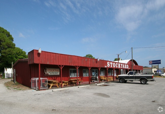
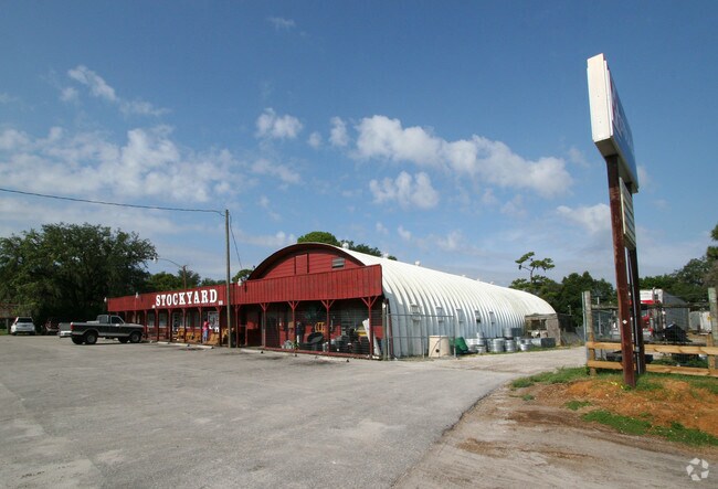
Property Record
1010 Cattlemen Rd, Sarasota, FL 34232
Save to a Folder
{{folder.Name}}
{{folder.ListingIds.length}} Properties
{{folder.ListingIds.length}} Property
Create a New Folder
Property Detail
1010 Cattlemen Rd
North Port-Bradenton-Sarasota, FL
PORTION OF 130 FT WIDE ABANDONED RR R/W DESC AS COM AT NE COR OF LOT 4 BLK K HIGHLAND CREST SUB TH NLY 10.15 FT TH NWLY & PARALLEL WITH NLY LINE OF BLK K 10.15 FT FOR POB TH CONT NWLY ALG SLY LINE
0048-10-0062
Sarasota
Shipyard
Florida
CI
4
C and X Area of minimal flood hazard, usually depicted on FIRMs as above the 500-year flood level.
0.91 AC
2024
Sarasota
2025
Tampa/St Petersburg
001302
NEARBY LISTINGS FOR SALE OR LEASE
DEMOGRAPHICS near 1010 Cattlemen Rd
1 mile
3 mile
5 mile
2025 Total Population
5,928
57,662
148,678
2030 Population
6,244
60,660
157,438
Pop Growth 2025-2030
+ 5.33%
+ 5.20%
+ 5.89%
Average Age
41
45
46
2025 Total Households
2,361
24,615
64,802
HH Growth 2025-2030
+ 5.08%
+ 5.18%
+ 5.86%
Median Household Inc
$76,939
$82,594
$78,942
Avg Household Size
2.30
2.20
2.20
2025 Avg HH Vehicles
2.00
2.00
2.00
Median Home Value
$415,479
$417,270
$433,627
Median Year Built
1988
1985
1984
Nearby Places
Map Layers
Map Styles
 Street
 Aerial
Layers
 Traffic
 Biking
Places
Listings with unknown addresses are not visible on the map
- Restaurants
- Banks
- Shops
- Fitness
- Groceries
PUBLIC TRANSPORTATION
AIRPORT
Sarasota/Bradenton International
Drive
Walk
Distance
Sarasota/Bradenton International
22 min
11.1 mi
Punta Gorda
Drive
Walk
Distance
Punta Gorda
59 min
48.8 mi
Nearby Properties
Address
Land Use
TOTAL SIZE
Lot Size
Zoning
Address
Land Use
TOTAL SIZE
Lot Size
Zoning
92,398 SF
178.58 AC
OUE1
Address
Land Use
TOTAL SIZE
Lot Size
Zoning
409,467 SF
36.72 AC
RMF2
Address
Land Use
TOTAL SIZE
Lot Size
Zoning
359,089 SF
16.72 AC
PCD
Address
Land Use
TOTAL SIZE
Lot Size
Zoning
370,367 SF
27.32 AC
OPI
Address
Land Use
TOTAL SIZE
Lot Size
Zoning
366,256 SF
32.53 AC
RMF3
Address
Land Use
TOTAL SIZE
Lot Size
Zoning
332,686 SF
37.78 AC
VPD
Address
Land Use
TOTAL SIZE
Lot Size
Zoning
318,350 SF
14.30 AC
ILW
Address
Land Use
TOTAL SIZE
Lot Size
Zoning
415,689 SF
37.52 AC
OPI
Address
Land Use
TOTAL SIZE
Lot Size
Zoning
350,210 SF
13.36 AC
PED
Address
Land Use
TOTAL SIZE
Lot Size
Zoning
334,284 SF
30.55 AC
RMF3
Address
Land Use
TOTAL SIZE
Lot Size
Zoning
349,363 SF
22.58 AC
VPD
Address
Land Use
TOTAL SIZE
Lot Size
Zoning
352,070 SF
8.87 AC
ILW
Address
Land Use
TOTAL SIZE
Lot Size
Zoning
263,961 SF
18.88 AC
RMF3
Address
Land Use
TOTAL SIZE
Lot Size
Zoning
313,441 SF
26.91 AC
RSF2
Address
Land Use
TOTAL SIZE
Lot Size
Zoning
216,684 SF
30.52 AC
RMF2
Address
Land Use
TOTAL SIZE
Lot Size
Zoning
94,981 SF
6 AC
PCD
Address
Land Use
TOTAL SIZE
Lot Size
Zoning
374,477 SF
15.55 AC
PED
Address
Land Use
TOTAL SIZE
Lot Size
Zoning
206,788 SF
122.30 AC
GU
Address
Land Use
TOTAL SIZE
Lot Size
Zoning
195,342 SF
20.20 AC
CSC
Address
Land Use
TOTAL SIZE
Lot Size
Zoning
170,631 SF
23.70 AC
RMF2
Address
Land Use
TOTAL SIZE
Lot Size
Zoning
157,351 SF
10.98 AC
ILW
Address
Land Use
TOTAL SIZE
Lot Size
Zoning
109,470 SF
17.23 AC
RSF2
Address
Land Use
TOTAL SIZE
Lot Size
Zoning
118,713 SF
31.70 AC
MCI
Address
Land Use
TOTAL SIZE
Lot Size
Zoning
196,331 SF
55.82 AC
GU
Address
Land Use
TOTAL SIZE
Lot Size
Zoning
139,916 SF
10.05 AC
PCD
Address
Land Use
TOTAL SIZE
Lot Size
Zoning
86,651 SF
22.68 AC
PED
Address
Land Use
TOTAL SIZE
Lot Size
Zoning
205,136 SF
17.32 AC
RMF2
Address
Land Use
TOTAL SIZE
Lot Size
Zoning
6,232 SF
37.84 AC
RMH
Address
Land Use
TOTAL SIZE
Lot Size
Zoning
64,454 SF
2.56 AC
PED
Address
Land Use
TOTAL SIZE
Lot Size
Zoning
89,318 SF
13.62 AC
CSC
The World's #1 Commercial Real Estate Marketplace
Connect with us
© 2026 CoStar Group
The information above has been obtained from sources believed reliable. While we do not doubt its accuracy we have not verified it and make no guarantee, warranty or representation about it. It is your responsibility to independently confirm its accuracy and completeness. Any projections, opinions, assumptions, or estimates used are for example only and do not represent the current or future performance of the property. The value of this transaction to you depends on tax and other factors which should be evaluated by your tax, financial, and legal advisors. You and your advisors should conduct a careful, independent investigation of the property to determine to your satisfaction the suitability of the property for your needs.