Property Record
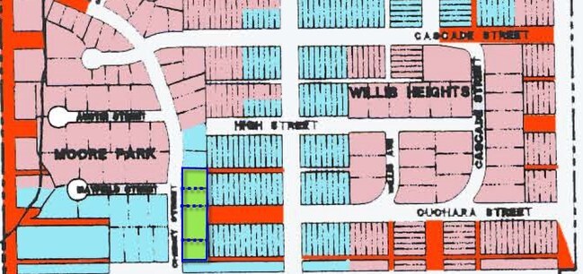
1010 Cherry St, La Veta, CO 81055
Property Detail
1010 Cherry St
Other Market Areas
LOT 2 BLOCK 1, MOORE PK. 371- 45-46 368-870 370-506 370-507 373-171 375-679-680 #333673 #376712 400930 402582 402583 404880
144831
Huerfano
Multipleuses
Colorado
2025
2
2025
0.58 AC
960901
Colorado East Area
8,006 SF
NEARBY LISTINGS FOR SALE OR LEASE
DEMOGRAPHICS near 1010 Cherry St
1 mile
3 mile
5 mile
2025 Total Population
719
879
931
2030 Population
730
893
945
Pop Growth 2025-2030
+ 1.53%
+ 1.59%
+ 1.50%
Average Age
54
54
54
2025 Total Households
348
425
450
HH Growth 2025-2030
+ 1.44%
+ 1.65%
+ 1.56%
Median Household Inc
$58,208
$58,231
$58,371
Avg Household Size
2.00
2.00
2.00
2025 Avg HH Vehicles
2.00
2.00
2.00
Median Home Value
$440,384
$440,625
$440,441
Median Year Built
1979
1979
1979
Nearby Places
Map Layers
Map Styles
 Street
 Aerial
Layers
 Traffic
 Biking
Places
Listings with unknown addresses are not visible on the map
- Restaurants
- Banks
- Shops
- Fitness
- Groceries
Nearby Properties
Address
Land Use
TOTAL SIZE
Lot Size
Zoning
Address
Land Use
TOTAL SIZE
Lot Size
Zoning
33.04 AC
Address
Land Use
TOTAL SIZE
Lot Size
Zoning
2,247 SF
748.62 AC
Address
Land Use
TOTAL SIZE
Lot Size
Zoning
9,992 SF
0.23 AC
Address
Land Use
TOTAL SIZE
Lot Size
Zoning
486 SF
160 AC
Address
Land Use
TOTAL SIZE
Lot Size
Zoning
89.55 AC
Address
Land Use
TOTAL SIZE
Lot Size
Zoning
Address
Land Use
TOTAL SIZE
Lot Size
Zoning
1,510 SF
310.25 AC
Address
Land Use
TOTAL SIZE
Lot Size
Zoning
3,652 SF
0.92 AC
Address
Land Use
TOTAL SIZE
Lot Size
Zoning
0.86 AC
Address
Land Use
TOTAL SIZE
Lot Size
Zoning
2,255 SF
0.23 AC
Address
Land Use
TOTAL SIZE
Lot Size
Zoning
2,600 SF
3.34 AC
Address
Land Use
TOTAL SIZE
Lot Size
Zoning
2,562 SF
0.17 AC
Address
Land Use
TOTAL SIZE
Lot Size
Zoning
8,227 SF
35.04 AC
Address
Land Use
TOTAL SIZE
Lot Size
Zoning
4,844 SF
0.17 AC
Address
Land Use
TOTAL SIZE
Lot Size
Zoning
6,928 SF
3.22 AC
Address
Land Use
TOTAL SIZE
Lot Size
Zoning
0.70 AC
Address
Land Use
TOTAL SIZE
Lot Size
Zoning
3,200 SF
0.90 AC
Address
Land Use
TOTAL SIZE
Lot Size
Zoning
5,336 SF
0.09 AC
Address
Land Use
TOTAL SIZE
Lot Size
Zoning
3,200 SF
13.81 AC
Address
Land Use
TOTAL SIZE
Lot Size
Zoning
7,266 SF
0.52 AC
Address
Land Use
TOTAL SIZE
Lot Size
Zoning
3,853 SF
1.04 AC
Address
Land Use
TOTAL SIZE
Lot Size
Zoning
2,288 SF
0.44 AC
Address
Land Use
TOTAL SIZE
Lot Size
Zoning
39.31 AC
Address
Land Use
TOTAL SIZE
Lot Size
Zoning
1,904 SF
0.21 AC
Address
Land Use
TOTAL SIZE
Lot Size
Zoning
0.81 AC
Address
Land Use
TOTAL SIZE
Lot Size
Zoning
0.52 AC
Address
Land Use
TOTAL SIZE
Lot Size
Zoning
4,460 SF
81.09 AC
Address
Land Use
TOTAL SIZE
Lot Size
Zoning
10,001 SF
3.50 AC
Address
Land Use
TOTAL SIZE
Lot Size
Zoning
3,920 SF
0.34 AC
Address
Land Use
TOTAL SIZE
Lot Size
Zoning
5,326 SF
46.93 AC
The World's #1 Commercial Real Estate Marketplace
Connect with us
© 2026 CoStar Group
The information above has been obtained from sources believed reliable. While we do not doubt its accuracy we have not verified it and make no guarantee, warranty or representation about it. It is your responsibility to independently confirm its accuracy and completeness. Any projections, opinions, assumptions, or estimates used are for example only and do not represent the current or future performance of the property. The value of this transaction to you depends on tax and other factors which should be evaluated by your tax, financial, and legal advisors. You and your advisors should conduct a careful, independent investigation of the property to determine to your satisfaction the suitability of the property for your needs.