Property Record
1010 Constance Rd, Orlando, FL 32826


Save to a Folder
{{folder.Name}}
{{folder.ListingIds.length}} Properties
{{folder.ListingIds.length}} Property
Create a New Folder
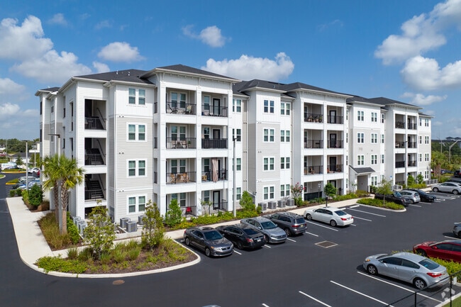
Property Detail
1010 Constance Rd
23-2231-9094-01-000
WATERFORD LAKES MULTIFAMILY 109/21 LOT 1
Apartment
ORANGE
P-D
Florida
B and X Area of moderate flood hazard, usually the area between the limits of the 100-year and 500-year floods.
1
2025
Waterford Lakes
2026
Orlando
016743
Orlando-Kissimmee-Sanford, FL
255,139 SF
NEARBY LISTINGS FOR SALE OR LEASE
-
-
View all Orlando listings for sale on LoopNet.com
DEMOGRAPHICS near 1010 Constance Rd
1 mile
3 mile
5 mile
2025 Total Population
18,456
111,096
235,285
2030 Population
20,296
119,852
253,695
Pop Growth 2025-2030
+ 9.97%
+ 7.88%
+ 7.82%
Average Age
33
34
36
2025 Total Households
6,746
34,541
77,291
HH Growth 2025-2030
+ 10.44%
+ 9.02%
+ 8.55%
Median Household Inc
$57,148
$70,387
$82,431
Avg Household Size
2.50
2.60
2.70
2025 Avg HH Vehicles
2.00
2.00
2.00
Median Home Value
$319,872
$363,120
$383,625
Median Year Built
2001
1996
1997
Nearby Places
Map Layers
Map Styles
 Street
 Aerial
Layers
 Traffic
 Biking
Places
Listings with unknown addresses are not visible on the map
- Restaurants
- Banks
- Shops
- Fitness
- Groceries
PUBLIC TRANSPORTATION
AIRPORT
Orlando International
Drive
Walk
Distance
Orlando International
24 min
16.3 mi
Orlando Sanford International
Drive
Walk
Distance
Orlando Sanford International
30 min
19.3 mi
Freight Ports
Port Canaveral
Drive
Walk
Distance
Port Canaveral
52 min
40.1 mi
Nearby Properties
Address
Land Use
TOTAL SIZE
Lot Size
Zoning
Address
Land Use
TOTAL SIZE
Lot Size
Zoning
8,247,372 SF
1,194.20 AC
R-3
Address
Land Use
TOTAL SIZE
Lot Size
Zoning
645,236 SF
74.12 AC
P-D
Address
Land Use
TOTAL SIZE
Lot Size
Zoning
1,134,933 SF
261.65 AC
P-D
Address
Land Use
TOTAL SIZE
Lot Size
Zoning
1,198,236 SF
0.47 AC
P-D
Address
Land Use
TOTAL SIZE
Lot Size
Zoning
622,758 SF
P-D
Address
Land Use
TOTAL SIZE
Lot Size
Zoning
499,830 SF
24.65 AC
R-3
Address
Land Use
TOTAL SIZE
Lot Size
Zoning
867,901 SF
36.21 AC
P-D
Address
Land Use
TOTAL SIZE
Lot Size
Zoning
745,346 SF
9.94 AC
P-D
Address
Land Use
TOTAL SIZE
Lot Size
Zoning
447,816 SF
37.44 AC
P-D
Address
Land Use
TOTAL SIZE
Lot Size
Zoning
605,303 SF
39.84 AC
P-D
Address
Land Use
TOTAL SIZE
Lot Size
Zoning
523,131 SF
3.82 AC
P-D
Address
Land Use
TOTAL SIZE
Lot Size
Zoning
358,221 SF
40.57 AC
IND-2/IND-
Address
Land Use
TOTAL SIZE
Lot Size
Zoning
517,774 SF
U-ORG-P-D
Address
Land Use
TOTAL SIZE
Lot Size
Zoning
499,133 SF
22.04 AC
P-D
Address
Land Use
TOTAL SIZE
Lot Size
Zoning
552,060 SF
6.97 AC
P-D
Address
Land Use
TOTAL SIZE
Lot Size
Zoning
599,187 SF
5.16 AC
P-D
Address
Land Use
TOTAL SIZE
Lot Size
Zoning
364,015 SF
39.43 AC
R-3
Address
Land Use
TOTAL SIZE
Lot Size
Zoning
573,835 SF
5.27 AC
P-D
Address
Land Use
TOTAL SIZE
Lot Size
Zoning
304,529 SF
19.98 AC
P-D
Address
Land Use
TOTAL SIZE
Lot Size
Zoning
411,516 SF
1.18 AC
P-D
Address
Land Use
TOTAL SIZE
Lot Size
Zoning
500,686 SF
24.16 AC
P-D
Address
Land Use
TOTAL SIZE
Lot Size
Zoning
380,024 SF
P-D
Address
Land Use
TOTAL SIZE
Lot Size
Zoning
470,251 SF
19.92 AC
R-3
Address
Land Use
TOTAL SIZE
Lot Size
Zoning
370,136 SF
15.43 AC
P-D
Address
Land Use
TOTAL SIZE
Lot Size
Zoning
423,348 SF
18.63 AC
P-D
Address
Land Use
TOTAL SIZE
Lot Size
Zoning
237,783 SF
12.12 AC
IND-2/IND-
Address
Land Use
TOTAL SIZE
Lot Size
Zoning
255,677 SF
95.62 AC
P-D
Address
Land Use
TOTAL SIZE
Lot Size
Zoning
331,418 SF
14.85 AC
P-D
Address
Land Use
TOTAL SIZE
Lot Size
Zoning
334,976 SF
18.75 AC
P-D
The World's #1 Commercial Real Estate Marketplace
Connect with us
© 2026 CoStar Group
The information above has been obtained from sources believed reliable. While we do not doubt its accuracy we have not verified it and make no guarantee, warranty or representation about it. It is your responsibility to independently confirm its accuracy and completeness. Any projections, opinions, assumptions, or estimates used are for example only and do not represent the current or future performance of the property. The value of this transaction to you depends on tax and other factors which should be evaluated by your tax, financial, and legal advisors. You and your advisors should conduct a careful, independent investigation of the property to determine to your satisfaction the suitability of the property for your needs.