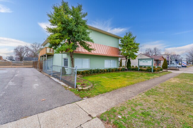
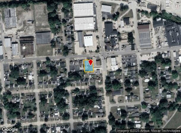
Property Record
1010 E 18Th St, Owensboro, KY 42303

NEARBY LISTINGS FOR SALE OR LEASE
Property Detail
1010 E 18Th St
003-03-04-001-B0-000
Fair Grounds Addition
Commercialnec
3-3-4-1B1010 E 18TH ST91 X 123
X
Daviess
21059C0138E
Kentucky
2025
0.26 AC
2025
Kentucky West Area
000401
Other Market Areas
5,826 SF
Owensboro, KY
DEMOGRAPHICS near 1010 E 18Th St
1 Mile
3 Mile
5 Mile
2024 Total Population
11,137
59,327
76,628
2029 Population
11,240
59,676
76,890
Pop Growth 2024-2029
+ 0.92%
+ 0.59%
+ 0.34%
Average Age
38
40
40
2024 Total Households
4,639
24,451
31,281
HH Growth 2024-2029
+ 0.93%
+ 0.62%
+ 0.36%
Median Household Inc
$38,248
$53,382
$55,789
Avg Household Size
2.30
2.30
2.30
2024 Avg HH Vehicles
2.00
2.00
2.00
Median Home Value
$105,947
$156,484
$162,172
Median Year Built
1960
1970
1973
Nearby Places
Map Layers
Map Styles
 Street
 Aerial
- Restaurants
- Banks
- Shops
- Fitness
- Groceries
SALE & LEASE HISTORY
LISTING DATE
SALE/LEASE

Mar 07, 2024
For Sale
Nearby Properties
Address
Land Use
TOTAL SIZE
Lot Size
Zoning
Address
Land Use
TOTAL SIZE
Lot Size
Zoning
975,956 SF
143.98 AC
Address
Land Use
TOTAL SIZE
Lot Size
Zoning
169,482 SF
10.21 AC
Address
Land Use
TOTAL SIZE
Lot Size
Zoning
3,610 SF
1.23 AC
Address
Land Use
TOTAL SIZE
Lot Size
Zoning
4,361 SF
17.09 AC
Address
Land Use
TOTAL SIZE
Lot Size
Zoning
450,235 SF
24.61 AC
Address
Land Use
TOTAL SIZE
Lot Size
Zoning
184,854 SF
9.46 AC
Address
Land Use
TOTAL SIZE
Lot Size
Zoning
371,705 SF
57.02 AC
Address
Land Use
TOTAL SIZE
Lot Size
Zoning
88,745 SF
2.62 AC
Address
Land Use
TOTAL SIZE
Lot Size
Zoning
28,032 SF
18.13 AC
Address
Land Use
TOTAL SIZE
Lot Size
Zoning
227,450 SF
30.70 AC
Address
Land Use
TOTAL SIZE
Lot Size
Zoning
46,184 SF
1.99 AC
Address
Land Use
TOTAL SIZE
Lot Size
Zoning
215,840 SF
14 AC
Address
Land Use
TOTAL SIZE
Lot Size
Zoning
113,025 SF
2.10 AC
Address
Land Use
TOTAL SIZE
Lot Size
Zoning
187,364 SF
18.64 AC
Address
Land Use
TOTAL SIZE
Lot Size
Zoning
4.73 AC
Address
Land Use
TOTAL SIZE
Lot Size
Zoning
62,312 SF
0.88 AC
Address
Land Use
TOTAL SIZE
Lot Size
Zoning
29,600 SF
3.38 AC
Address
Land Use
TOTAL SIZE
Lot Size
Zoning
478,052 SF
26.50 AC
Address
Land Use
TOTAL SIZE
Lot Size
Zoning
165,207 SF
15.76 AC
Address
Land Use
TOTAL SIZE
Lot Size
Zoning
214,489 SF
22.72 AC
Address
Land Use
TOTAL SIZE
Lot Size
Zoning
7.63 AC
Address
Land Use
TOTAL SIZE
Lot Size
Zoning
Address
Land Use
TOTAL SIZE
Lot Size
Zoning
9,725 SF
22.36 AC
Address
Land Use
TOTAL SIZE
Lot Size
Zoning
215,439 SF
15.02 AC
Address
Land Use
TOTAL SIZE
Lot Size
Zoning
82,027 SF
2.40 AC
Address
Land Use
TOTAL SIZE
Lot Size
Zoning
38,052 SF
11.46 AC
Address
Land Use
TOTAL SIZE
Lot Size
Zoning
655,471 SF
31.03 AC
Address
Land Use
TOTAL SIZE
Lot Size
Zoning
53,280 SF
Address
Land Use
TOTAL SIZE
Lot Size
Zoning
280 SF
2.60 AC
Address
Land Use
TOTAL SIZE
Lot Size
Zoning
67,431 SF
3.53 AC
The World's #1 Commercial Real Estate Marketplace
Connect with us
© 2026 CoStar Group
The information above has been obtained from sources believed reliable. While we do not doubt its accuracy we have not verified it and make no guarantee, warranty or representation about it. It is your responsibility to independently confirm its accuracy and completeness. Any projections, opinions, assumptions, or estimates used are for example only and do not represent the current or future performance of the property. The value of this transaction to you depends on tax and other factors which should be evaluated by your tax, financial, and legal advisors. You and your advisors should conduct a careful, independent investigation of the property to determine to your satisfaction the suitability of the property for your needs.