Property Record
1010 E 41St St, Hays, KS 67601

Save to a Folder
{{folder.Name}}
{{folder.ListingIds.length}} Properties
{{folder.ListingIds.length}} Property
Create a New Folder
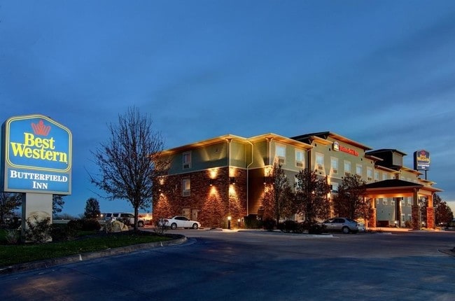
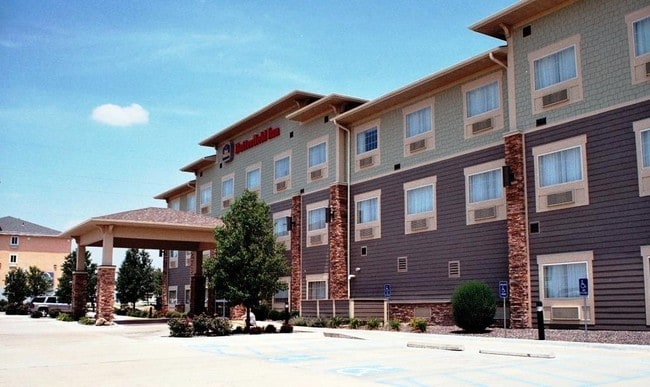
Property Detail
1010 E 41St St
Hays, KS
LUNDY ADDITION, BLOCK 01, LOT 1, ACRES 2.1, SECTION 27 TOWNSHIP 13 RANGE 18
138-27-0-20-01-003.00
Ellis
Hotel
Kansas
2025
1
2025
2.07 AC
072702
I-70 Corridor
46,549 SF
Other Market Areas
NEARBY LISTINGS FOR SALE OR LEASE
-
-
View all Hays listings for sale on LoopNet.com
DEMOGRAPHICS near 1010 E 41St St
1 mile
3 mile
5 mile
2025 Total Population
3,145
21,716
23,448
2030 Population
3,177
21,856
23,651
Pop Growth 2025-2030
+ 1.02%
+ 0.64%
+ 0.87%
Average Age
40
37
37
2025 Total Households
1,278
8,856
9,531
HH Growth 2025-2030
+ 1.25%
+ 0.71%
+ 0.92%
Median Household Inc
$64,639
$56,883
$57,116
Avg Household Size
2.30
2.20
2.20
2025 Avg HH Vehicles
2.00
2.00
2.00
Median Home Value
$240,596
$234,333
$233,026
Median Year Built
1980
1973
1974
Nearby Places
Map Layers
Map Styles
 Street
 Aerial
Layers
 Traffic
 Biking
Places
Listings with unknown addresses are not visible on the map
- Restaurants
- Banks
- Shops
- Fitness
- Groceries
Nearby Properties
Address
Land Use
TOTAL SIZE
Lot Size
Zoning
Address
Land Use
TOTAL SIZE
Lot Size
Zoning
39,254 SF
118.58 AC
Address
Land Use
TOTAL SIZE
Lot Size
Zoning
181,401 SF
119.91 AC
Address
Land Use
TOTAL SIZE
Lot Size
Zoning
220,849 SF
23.18 AC
CO
Address
Land Use
TOTAL SIZE
Lot Size
Zoning
81,666 SF
4.50 AC
Address
Land Use
TOTAL SIZE
Lot Size
Zoning
108,893 SF
4.12 AC
C0
Address
Land Use
TOTAL SIZE
Lot Size
Zoning
88,198 SF
61.10 AC
Address
Land Use
TOTAL SIZE
Lot Size
Zoning
91,595 SF
3.60 AC
C1
Address
Land Use
TOTAL SIZE
Lot Size
Zoning
85,083 SF
11.82 AC
Address
Land Use
TOTAL SIZE
Lot Size
Zoning
36,920 SF
5.10 AC
Address
Land Use
TOTAL SIZE
Lot Size
Zoning
96,409 SF
23.61 AC
Address
Land Use
TOTAL SIZE
Lot Size
Zoning
64,096 SF
2.34 AC
Address
Land Use
TOTAL SIZE
Lot Size
Zoning
43,413 SF
Address
Land Use
TOTAL SIZE
Lot Size
Zoning
54,487 SF
0.20 AC
Address
Land Use
TOTAL SIZE
Lot Size
Zoning
17,209 SF
4.13 AC
R3
Address
Land Use
TOTAL SIZE
Lot Size
Zoning
44,496 SF
18.26 AC
Address
Land Use
TOTAL SIZE
Lot Size
Zoning
27,580 SF
0.74 AC
Address
Land Use
TOTAL SIZE
Lot Size
Zoning
7,034 SF
26.79 AC
Address
Land Use
TOTAL SIZE
Lot Size
Zoning
40,742 SF
8 AC
Address
Land Use
TOTAL SIZE
Lot Size
Zoning
20,273 SF
3.20 AC
Address
Land Use
TOTAL SIZE
Lot Size
Zoning
25,272 SF
9.50 AC
C2
Address
Land Use
TOTAL SIZE
Lot Size
Zoning
43,324 SF
10.30 AC
R3
Address
Land Use
TOTAL SIZE
Lot Size
Zoning
352,874 SF
112.67 AC
Address
Land Use
TOTAL SIZE
Lot Size
Zoning
22,881 SF
31.26 AC
Address
Land Use
TOTAL SIZE
Lot Size
Zoning
1,173 SF
485.40 AC
Address
Land Use
TOTAL SIZE
Lot Size
Zoning
22,302 SF
2.72 AC
C0
Address
Land Use
TOTAL SIZE
Lot Size
Zoning
25,536 SF
0.72 AC
Address
Land Use
TOTAL SIZE
Lot Size
Zoning
76,919 SF
2 AC
Address
Land Use
TOTAL SIZE
Lot Size
Zoning
49,138 SF
2.79 AC
Address
Land Use
TOTAL SIZE
Lot Size
Zoning
23,326 SF
1.64 AC
Address
Land Use
TOTAL SIZE
Lot Size
Zoning
4,356 SF
119 AC
The World's #1 Commercial Real Estate Marketplace
Connect with us
© 2026 CoStar Group
The information above has been obtained from sources believed reliable. While we do not doubt its accuracy we have not verified it and make no guarantee, warranty or representation about it. It is your responsibility to independently confirm its accuracy and completeness. Any projections, opinions, assumptions, or estimates used are for example only and do not represent the current or future performance of the property. The value of this transaction to you depends on tax and other factors which should be evaluated by your tax, financial, and legal advisors. You and your advisors should conduct a careful, independent investigation of the property to determine to your satisfaction the suitability of the property for your needs.