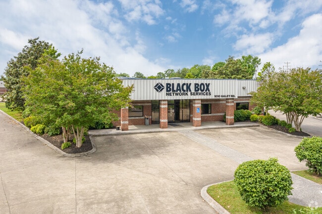
Property Record
1010 Haley Rd, Murfreesboro, TN 37129


Save to a Folder
{{folder.Name}}
{{folder.ListingIds.length}} Properties
{{folder.ListingIds.length}} Property
Create a New Folder
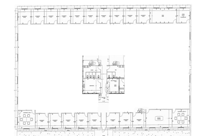
Property Detail
1010 Haley Rd
Officebuilding
Rutherford
HI
Tennessee
B and X Area of moderate flood hazard, usually the area between the limits of the 100-year and 500-year floods.
5.04 AC
0
Rutherford County
2025
Nashville
041800
Nashville-Davidson--Murfreesboro--Franklin, TN
42,360 SF
102-019.28-000
NEARBY LISTINGS FOR SALE OR LEASE
DEMOGRAPHICS near 1010 Haley Rd
1 mile
3 mile
5 mile
2025 Total Population
4,687
76,063
167,838
2030 Population
5,065
81,590
181,339
Pop Growth 2025-2030
+ 8.06%
+ 7.27%
+ 8.04%
Average Age
36
35
36
2025 Total Households
1,541
30,842
65,524
HH Growth 2025-2030
+ 8.96%
+ 7.60%
+ 8.24%
Median Household Inc
$50,503
$58,699
$75,022
Avg Household Size
2.40
2.30
2.50
2025 Avg HH Vehicles
2.00
2.00
2.00
Median Home Value
$356,504
$365,696
$413,164
Median Year Built
1978
1991
1998
Nearby Places
Map Layers
Map Styles
 Street
 Aerial
Layers
 Traffic
 Biking
Places
Listings with unknown addresses are not visible on the map
- Restaurants
- Banks
- Shops
- Fitness
- Groceries
PUBLIC TRANSPORTATION
AIRPORT
Nashville International
Drive
Walk
Distance
Nashville International
36 min
28.9 mi
Freight Ports
Port of Mobile
Drive
Walk
Distance
Port of Mobile
491 min
449.9 mi
SALE & LEASE HISTORY
LISTING DATE
SALE/LEASE

May 18, 2020
For Lease
Jul 05, 2018
For Sale
Jan 03, 2019
For Sale
Feb 11, 2021
For Lease
Apr 24, 2023
For Sale
Nearby Properties
Address
Land Use
TOTAL SIZE
Lot Size
Zoning
Address
Land Use
TOTAL SIZE
Lot Size
Zoning
969,473 SF
43.50 AC
Address
Land Use
TOTAL SIZE
Lot Size
Zoning
812,152 SF
85.61 AC
Address
Land Use
TOTAL SIZE
Lot Size
Zoning
30,630 SF
8.50 AC
Address
Land Use
TOTAL SIZE
Lot Size
Zoning
166,604 SF
2.21 AC
Address
Land Use
TOTAL SIZE
Lot Size
Zoning
104,174 SF
11.06 AC
Address
Land Use
TOTAL SIZE
Lot Size
Zoning
12,391 SF
20.36 AC
Address
Land Use
TOTAL SIZE
Lot Size
Zoning
295,095 SF
80 AC
Address
Land Use
TOTAL SIZE
Lot Size
Zoning
5,260 SF
21.91 AC
Address
Land Use
TOTAL SIZE
Lot Size
Zoning
231,649 SF
19.95 AC
Address
Land Use
TOTAL SIZE
Lot Size
Zoning
17,330 SF
10.20 AC
Address
Land Use
TOTAL SIZE
Lot Size
Zoning
10,760 SF
19.48 AC
Address
Land Use
TOTAL SIZE
Lot Size
Zoning
7,704 SF
17.15 AC
CF
Address
Land Use
TOTAL SIZE
Lot Size
Zoning
408,067 SF
33.01 AC
CH
Address
Land Use
TOTAL SIZE
Lot Size
Zoning
13,818 SF
7.43 AC
Address
Land Use
TOTAL SIZE
Lot Size
Zoning
146,555 SF
3.22 AC
Address
Land Use
TOTAL SIZE
Lot Size
Zoning
12,794 SF
20.44 AC
RM16
Address
Land Use
TOTAL SIZE
Lot Size
Zoning
160,540 SF
20.19 AC
Address
Land Use
TOTAL SIZE
Lot Size
Zoning
120,225 SF
20.40 AC
Address
Land Use
TOTAL SIZE
Lot Size
Zoning
5,308 SF
14.95 AC
Address
Land Use
TOTAL SIZE
Lot Size
Zoning
102,366 SF
7.90 AC
Address
Land Use
TOTAL SIZE
Lot Size
Zoning
4,842 SF
17.80 AC
Address
Land Use
TOTAL SIZE
Lot Size
Zoning
7,886 SF
19.04 AC
RMF
Address
Land Use
TOTAL SIZE
Lot Size
Zoning
113,271 SF
27.70 AC
Address
Land Use
TOTAL SIZE
Lot Size
Zoning
4,409 SF
21.60 AC
RM16
Address
Land Use
TOTAL SIZE
Lot Size
Zoning
78,768 SF
1.50 AC
Address
Land Use
TOTAL SIZE
Lot Size
Zoning
3,104 SF
16.01 AC
RM16
Address
Land Use
TOTAL SIZE
Lot Size
Zoning
403,206 SF
63.11 AC
Address
Land Use
TOTAL SIZE
Lot Size
Zoning
120,638 SF
20.55 AC
Address
Land Use
TOTAL SIZE
Lot Size
Zoning
864 SF
15.43 AC
RM16
Address
Land Use
TOTAL SIZE
Lot Size
Zoning
114,829 SF
26 AC
The World's #1 Commercial Real Estate Marketplace
Connect with us
© 2026 CoStar Group
The information above has been obtained from sources believed reliable. While we do not doubt its accuracy we have not verified it and make no guarantee, warranty or representation about it. It is your responsibility to independently confirm its accuracy and completeness. Any projections, opinions, assumptions, or estimates used are for example only and do not represent the current or future performance of the property. The value of this transaction to you depends on tax and other factors which should be evaluated by your tax, financial, and legal advisors. You and your advisors should conduct a careful, independent investigation of the property to determine to your satisfaction the suitability of the property for your needs.