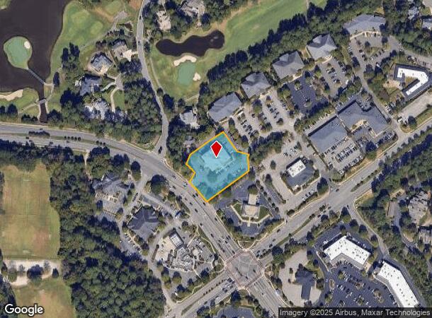
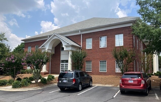
Property Record
1010 High House Rd, Cary, NC 27513

NEARBY LISTINGS FOR SALE OR LEASE
Property Detail
1010 High House Rd
Raleigh, NC
Preston Pud Prcl Po-2
0754.13-02-6623-000
LOA PRTN PRCL PO-2 PRESTON BM1995-257
Officebuilding
Wake
X
North Carolina
3720075400K
a
2025
1.14 AC
2025
Cary
053523
Raleigh/Durham
20,000 SF
DEMOGRAPHICS near 1010 High House Rd
1 Mile
3 Mile
5 Mile
2024 Total Population
8,866
97,979
206,703
2029 Population
9,477
106,168
224,823
Pop Growth 2024-2029
+ 6.89%
+ 8.36%
+ 8.77%
Average Age
41
39
38
2024 Total Households
3,420
37,951
78,439
HH Growth 2024-2029
+ 6.87%
+ 8.32%
+ 8.75%
Median Household Inc
$182,259
$117,345
$117,306
Avg Household Size
2.60
2.50
2.60
2024 Avg HH Vehicles
2.00
2.00
2.00
Median Home Value
$501,115
$428,508
$431,447
Median Year Built
1995
1996
1998
Nearby Places
Map Layers
Map Styles
 Street
 Aerial
- Restaurants
- Banks
- Shops
- Fitness
- Groceries
PUBLIC TRANSPORTATION
COMMUTER RAIL
Cary Station (Piedmont - North Carolina by Train (NC Train))
DRIVE
WALK
Distance
Cary Station (Piedmont - North Carolina by Train (NC Train))
7 min
3.2 mi
AIRPORT
Raleigh-Durham International
DRIVE
WALK
Distance
Raleigh-Durham International
17 min
8.4 mi
SALE & LEASE HISTORY
LISTING DATE
SALE/LEASE

Oct 27, 2023
For Lease
Jun 22, 2023
For Lease
Jun 04, 2018
For Lease
Jul 13, 2017
For Lease
Jan 14, 2019
For Lease
Nearby Properties
Address
Land Use
TOTAL SIZE
Lot Size
Zoning
Address
Land Use
TOTAL SIZE
Lot Size
Zoning
517,812 SF
18.51 AC
RMFP
Address
Land Use
TOTAL SIZE
Lot Size
Zoning
439,439 SF
30.59 AC
OICU
Address
Land Use
TOTAL SIZE
Lot Size
Zoning
534,604 SF
16.38 AC
RMFM
Address
Land Use
TOTAL SIZE
Lot Size
Zoning
433,914 SF
11.81 AC
MXD
Address
Land Use
TOTAL SIZE
Lot Size
Zoning
429,107 SF
13.67 AC
RMFP
Address
Land Use
TOTAL SIZE
Lot Size
Zoning
375,689 SF
32.73 AC
HDR
Address
Land Use
TOTAL SIZE
Lot Size
Zoning
312,475 SF
21.74 AC
RMFP
Address
Land Use
TOTAL SIZE
Lot Size
Zoning
453,970 SF
41.48 AC
RMF-C
Address
Land Use
TOTAL SIZE
Lot Size
Zoning
414,214 SF
11.23 AC
OIP
Address
Land Use
TOTAL SIZE
Lot Size
Zoning
444,236 SF
8.51 AC
ORDP
Address
Land Use
TOTAL SIZE
Lot Size
Zoning
269,702 SF
14.66 AC
GCM
Address
Land Use
TOTAL SIZE
Lot Size
Zoning
280,706 SF
15.38 AC
PUD-C
Address
Land Use
TOTAL SIZE
Lot Size
Zoning
368,195 SF
32.11 AC
HDR
Address
Land Use
TOTAL SIZE
Lot Size
Zoning
408,968 SF
32.58 AC
HDR
Address
Land Use
TOTAL SIZE
Lot Size
Zoning
323,036 SF
30.09 AC
RMF-C
Address
Land Use
TOTAL SIZE
Lot Size
Zoning
263,023 SF
72.48 AC
R40
Address
Land Use
TOTAL SIZE
Lot Size
Zoning
394,181 SF
28.62 AC
HDR
Address
Land Use
TOTAL SIZE
Lot Size
Zoning
364,972 SF
35.18 AC
RMF-C
Address
Land Use
TOTAL SIZE
Lot Size
Zoning
282,961 SF
5.59 AC
GCP
Address
Land Use
TOTAL SIZE
Lot Size
Zoning
358,853 SF
16.94 AC
RMFP
Address
Land Use
TOTAL SIZE
Lot Size
Zoning
226,107 SF
18.72 AC
RMFP
Address
Land Use
TOTAL SIZE
Lot Size
Zoning
330,232 SF
18.45 AC
OIP
Address
Land Use
TOTAL SIZE
Lot Size
Zoning
273,637 SF
19.57 AC
C-NAC
Address
Land Use
TOTAL SIZE
Lot Size
Zoning
294,088 SF
24.72 AC
RMF-C
Address
Land Use
TOTAL SIZE
Lot Size
Zoning
287,626 SF
14.61 AC
MUPD
Address
Land Use
TOTAL SIZE
Lot Size
Zoning
285,822 SF
24.57 AC
RMFP
Address
Land Use
TOTAL SIZE
Lot Size
Zoning
185,064 SF
1.56 AC
GCP
Address
Land Use
TOTAL SIZE
Lot Size
Zoning
409,343 SF
35.26 AC
RMF-C
Address
Land Use
TOTAL SIZE
Lot Size
Zoning
209,936 SF
55.26 AC
R8
Address
Land Use
TOTAL SIZE
Lot Size
Zoning
236,374 SF
20.53 AC
HDR
The World's #1 Commercial Real Estate Marketplace
Connect with us
© 2025 CoStar Group
The information above has been obtained from sources believed reliable. While we do not doubt its accuracy we have not verified it and make no guarantee, warranty or representation about it. It is your responsibility to independently confirm its accuracy and completeness. Any projections, opinions, assumptions, or estimates used are for example only and do not represent the current or future performance of the property. The value of this transaction to you depends on tax and other factors which should be evaluated by your tax, financial, and legal advisors. You and your advisors should conduct a careful, independent investigation of the property to determine to your satisfaction the suitability of the property for your needs.