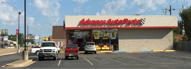
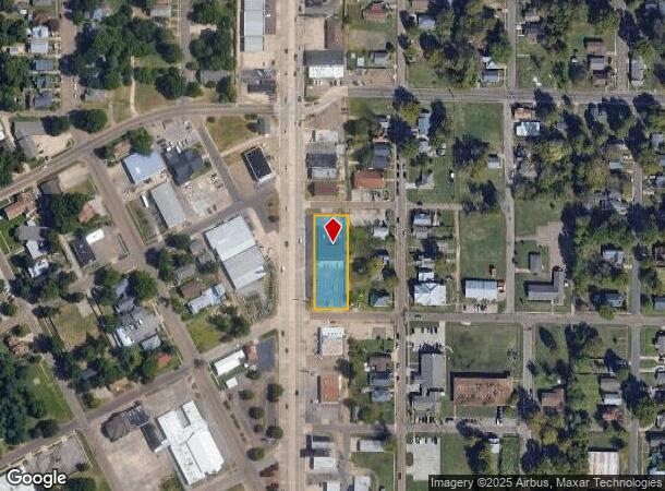
Property Record
1010 N State Line Ave, Texarkana, AR 71854

NEARBY LISTINGS FOR SALE OR LEASE
Property Detail
1010 N State Line Ave
Texarkana, TX-AR
Sproats
5130070
E 120' OF LOTS 9 THRU 15
Wholesaleoutletdiscountstore
Miller
X
Arkansas
48037C0370E
9-15
2025
0.77 AC
2025
Downtown Texarkana AR
020200
Other Market Areas
6,696 SF
DEMOGRAPHICS near 1010 N State Line Ave
1 Mile
3 Mile
5 Mile
2024 Total Population
7,905
46,740
74,044
2029 Population
8,019
47,149
74,283
Pop Growth 2024-2029
+ 1.44%
+ 0.88%
+ 0.32%
Average Age
38
38
39
2024 Total Households
2,824
18,734
29,424
HH Growth 2024-2029
+ 1.74%
+ 0.89%
+ 0.33%
Median Household Inc
$41,152
$36,679
$43,038
Avg Household Size
2.30
2.30
2.30
2024 Avg HH Vehicles
2.00
1.00
2.00
Median Home Value
$80,429
$107,985
$140,729
Median Year Built
1958
1974
1979
Nearby Places
Map Layers
Map Styles
 Street
 Aerial
- Restaurants
- Banks
- Shops
- Fitness
- Groceries
PUBLIC TRANSPORTATION
COMMUTER RAIL
Texarkana Amtrak Station (Texas Eagle - Amtrak)
DRIVE
WALK
Distance
Texarkana Amtrak Station (Texas Eagle - Amtrak)
2 min
19 min
1.0 mi
AIRPORT
Texarkana Regional-Webb Field
DRIVE
WALK
Distance
Texarkana Regional-Webb Field
11 min
4.1 mi
Freight Ports
Port of Shreveport
DRIVE
WALK
Distance
Port of Shreveport
107 min
93.5 mi
SALE & LEASE HISTORY
LISTING DATE
SALE/LEASE

Oct 05, 2016
For Sale
Oct 05, 2016
For Sale
Jun 04, 2018
For Sale
Nearby Properties
Address
Land Use
TOTAL SIZE
Lot Size
Zoning
Address
Land Use
TOTAL SIZE
Lot Size
Zoning
37.76 AC
Address
Land Use
TOTAL SIZE
Lot Size
Zoning
594,669 SF
26.19 AC
Address
Land Use
TOTAL SIZE
Lot Size
Zoning
22.35 AC
Address
Land Use
TOTAL SIZE
Lot Size
Zoning
Address
Land Use
TOTAL SIZE
Lot Size
Zoning
133,136 SF
5.80 AC
Address
Land Use
TOTAL SIZE
Lot Size
Zoning
11.66 AC
Address
Land Use
TOTAL SIZE
Lot Size
Zoning
3,642 SF
24.74 AC
Address
Land Use
TOTAL SIZE
Lot Size
Zoning
11,320 SF
142 AC
Address
Land Use
TOTAL SIZE
Lot Size
Zoning
97,914 SF
3.01 AC
Address
Land Use
TOTAL SIZE
Lot Size
Zoning
1,896,910 SF
46.19 AC
Address
Land Use
TOTAL SIZE
Lot Size
Zoning
2.07 AC
Address
Land Use
TOTAL SIZE
Lot Size
Zoning
73,675 SF
4.44 AC
Address
Land Use
TOTAL SIZE
Lot Size
Zoning
Address
Land Use
TOTAL SIZE
Lot Size
Zoning
8.19 AC
Address
Land Use
TOTAL SIZE
Lot Size
Zoning
533,299 SF
50.60 AC
Address
Land Use
TOTAL SIZE
Lot Size
Zoning
1,896,910 SF
Address
Land Use
TOTAL SIZE
Lot Size
Zoning
100,327 SF
Address
Land Use
TOTAL SIZE
Lot Size
Zoning
51,587 SF
6.44 AC
Address
Land Use
TOTAL SIZE
Lot Size
Zoning
32.42 AC
Address
Land Use
TOTAL SIZE
Lot Size
Zoning
82,125 SF
13.71 AC
Address
Land Use
TOTAL SIZE
Lot Size
Zoning
133,067 SF
11.20 AC
Address
Land Use
TOTAL SIZE
Lot Size
Zoning
124,978 SF
36.18 AC
Address
Land Use
TOTAL SIZE
Lot Size
Zoning
51,049 SF
1.78 AC
Address
Land Use
TOTAL SIZE
Lot Size
Zoning
109,855 SF
6.24 AC
Address
Land Use
TOTAL SIZE
Lot Size
Zoning
18,105 SF
2.50 AC
Address
Land Use
TOTAL SIZE
Lot Size
Zoning
175,650 SF
15.56 AC
Address
Land Use
TOTAL SIZE
Lot Size
Zoning
49,330 SF
2.26 AC
Address
Land Use
TOTAL SIZE
Lot Size
Zoning
160,484 SF
10.01 AC
Address
Land Use
TOTAL SIZE
Lot Size
Zoning
102,614 SF
0.89 AC
Address
Land Use
TOTAL SIZE
Lot Size
Zoning
22,103 SF
3.43 AC
The World's #1 Commercial Real Estate Marketplace
Connect with us
© 2025 CoStar Group
The information above has been obtained from sources believed reliable. While we do not doubt its accuracy we have not verified it and make no guarantee, warranty or representation about it. It is your responsibility to independently confirm its accuracy and completeness. Any projections, opinions, assumptions, or estimates used are for example only and do not represent the current or future performance of the property. The value of this transaction to you depends on tax and other factors which should be evaluated by your tax, financial, and legal advisors. You and your advisors should conduct a careful, independent investigation of the property to determine to your satisfaction the suitability of the property for your needs.