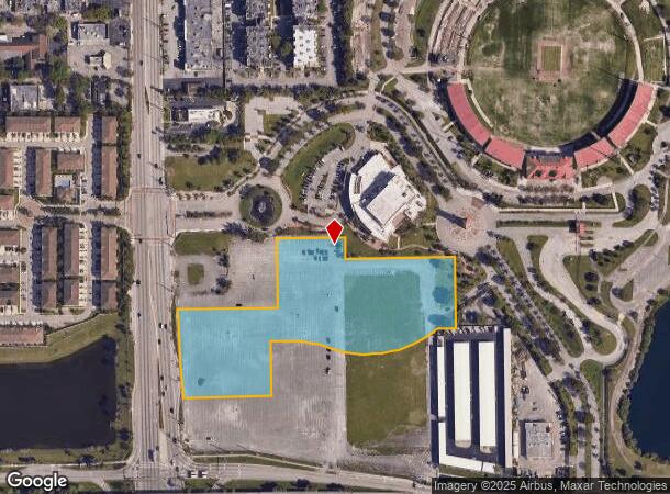
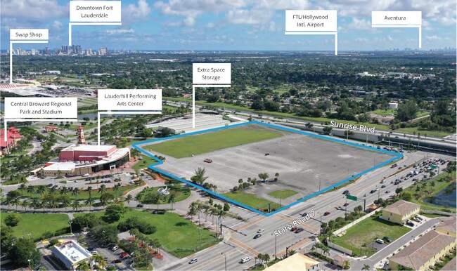
Property Record
1010 N State Road 7 Ave, Lauderhill, FL 33311


NEARBY LISTINGS FOR SALE OR LEASE
Property Detail
1010 N State Road 7 Ave
Fort Lauderdale-Pompano Beach-Deerfield Beach, FL
31-49-42
49-42-31-00-0320
31-49-42 PT OF GOV LOT 4 IN SW1/4,SEC 31 DESC AS:COMM SW COR SEC 31,N 290.26,E 122.97 TO POB,NW 51.18, NE 54.15,NW 202.51,NW 209.92,NE 174.17,N 181.80,E 370,S 70.64,E 350,S 229,W 56.99,S 463.66,SE 199.87,E 70.94,S 31.19,NW 42.46, NW 130.83,NW 66.35,N
Vacantlandnec
Broward
X
Florida
12011C0364J
4
0
5.87 AC
2025
Fort Lauderdale
041000
South Florida
DEMOGRAPHICS near 1010 N State Road 7 Ave
1 Mile
3 Mile
5 Mile
2024 Total Population
23,867
199,869
463,762
2029 Population
24,309
200,385
465,304
Pop Growth 2024-2029
+ 1.85%
+ 0.26%
+ 0.33%
Average Age
38
38
40
2024 Total Households
8,500
70,041
184,991
HH Growth 2024-2029
+ 1.89%
+ 0.22%
+ 0.20%
Median Household Inc
$40,112
$45,264
$56,337
Avg Household Size
2.70
2.70
2.40
2024 Avg HH Vehicles
1.00
2.00
2.00
Median Home Value
$252,128
$243,303
$288,846
Median Year Built
1969
1972
1976
Nearby Places
Map Layers
Map Styles
 Street
 Aerial
- Restaurants
- Banks
- Shops
- Fitness
- Groceries
PUBLIC TRANSPORTATION
COMMUTER RAIL
Fort Lauderdale (Tri-County Commuter - South Florida Regional Transportation Authority (Tri-Rail))
DRIVE
WALK
Distance
Fort Lauderdale (Tri-County Commuter - South Florida Regional Transportation Authority (Tri-Rail))
9 min
3.5 mi
Fort Lauderdale (Mainline - Brightline)
DRIVE
WALK
Distance
Fort Lauderdale (Mainline - Brightline)
10 min
4.6 mi
AIRPORT
Fort Lauderdale/Hollywood International
DRIVE
WALK
Distance
Fort Lauderdale/Hollywood International
16 min
9.0 mi
Miami International
DRIVE
WALK
Distance
Miami International
50 min
36.1 mi
Freight Ports
Port Everglades
DRIVE
WALK
Distance
Port Everglades
15 min
7.7 mi
SALE & LEASE HISTORY
LISTING DATE
SALE/LEASE

Dec 30, 2021
For Sale
Dec 22, 2021
For Sale
Dec 02, 2021
For Sale
Nearby Properties
Address
Land Use
TOTAL SIZE
Lot Size
Zoning
Address
Land Use
TOTAL SIZE
Lot Size
Zoning
346,662 SF
26.47 AC
RM-18
Address
Land Use
TOTAL SIZE
Lot Size
Zoning
278,398 SF
11.11 AC
RMM-25
Address
Land Use
TOTAL SIZE
Lot Size
Zoning
464,170 SF
43.19 AC
CF
Address
Land Use
TOTAL SIZE
Lot Size
Zoning
597,732 SF
55.47 AC
CF
Address
Land Use
TOTAL SIZE
Lot Size
Zoning
289,523 SF
9.44 AC
B-HCS
Address
Land Use
TOTAL SIZE
Lot Size
Zoning
300,359 SF
11.76 AC
PRD-15.7Q
Address
Land Use
TOTAL SIZE
Lot Size
Zoning
309,879 SF
7.78 AC
TND-PUD
Address
Land Use
TOTAL SIZE
Lot Size
Zoning
262,844 SF
10.85 AC
B-FCC
Address
Land Use
TOTAL SIZE
Lot Size
Zoning
291,638 SF
15.08 AC
PRD-15Q
Address
Land Use
TOTAL SIZE
Lot Size
Zoning
321,043 SF
34.99 AC
CF-P
Address
Land Use
TOTAL SIZE
Lot Size
Zoning
327,948 SF
30.42 AC
CF-P
Address
Land Use
TOTAL SIZE
Lot Size
Zoning
307,727 SF
17.53 AC
I
Address
Land Use
TOTAL SIZE
Lot Size
Zoning
692,139 SF
24.33 AC
RM-45
Address
Land Use
TOTAL SIZE
Lot Size
Zoning
281,912 SF
12.69 AC
B-4
Address
Land Use
TOTAL SIZE
Lot Size
Zoning
400,154 SF
9.69 AC
RM-45
Address
Land Use
TOTAL SIZE
Lot Size
Zoning
291,880 SF
10.33 AC
CF
Address
Land Use
TOTAL SIZE
Lot Size
Zoning
221,291 SF
12.40 AC
PUD
Address
Land Use
TOTAL SIZE
Lot Size
Zoning
319,321 SF
23.38 AC
CF
Address
Land Use
TOTAL SIZE
Lot Size
Zoning
285,942 SF
37.08 AC
CF
Address
Land Use
TOTAL SIZE
Lot Size
Zoning
312,794 SF
13.21 AC
I-1
Address
Land Use
TOTAL SIZE
Lot Size
Zoning
269,917 SF
31.52 AC
CF
Address
Land Use
TOTAL SIZE
Lot Size
Zoning
331,834 SF
14.66 AC
CF
Address
Land Use
TOTAL SIZE
Lot Size
Zoning
112,765 SF
14.23 AC
CF
Address
Land Use
TOTAL SIZE
Lot Size
Zoning
276,632 SF
20.01 AC
TC
Address
Land Use
TOTAL SIZE
Lot Size
Zoning
238,126 SF
17.79 AC
B-2P
Address
Land Use
TOTAL SIZE
Lot Size
Zoning
288,689 SF
29.58 AC
TC
Address
Land Use
TOTAL SIZE
Lot Size
Zoning
221,815 SF
12.05 AC
B-3
Address
Land Use
TOTAL SIZE
Lot Size
Zoning
348,637 SF
7.96 AC
RM-20
Address
Land Use
TOTAL SIZE
Lot Size
Zoning
106,923 SF
109.25 AC
PR
Address
Land Use
TOTAL SIZE
Lot Size
Zoning
331,199 SF
7.35 AC
RM-45
The World's #1 Commercial Real Estate Marketplace
Connect with us
© 2025 CoStar Group
The information above has been obtained from sources believed reliable. While we do not doubt its accuracy we have not verified it and make no guarantee, warranty or representation about it. It is your responsibility to independently confirm its accuracy and completeness. Any projections, opinions, assumptions, or estimates used are for example only and do not represent the current or future performance of the property. The value of this transaction to you depends on tax and other factors which should be evaluated by your tax, financial, and legal advisors. You and your advisors should conduct a careful, independent investigation of the property to determine to your satisfaction the suitability of the property for your needs.