Property Record
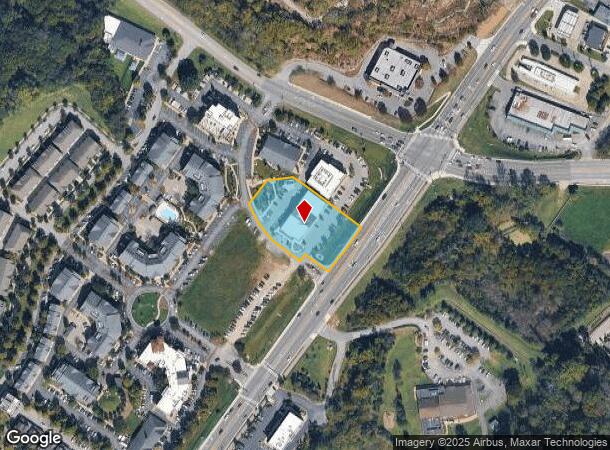
1010 Perrone Way, Franklin, TN 37069
NEARBY LISTINGS FOR SALE OR LEASE
Property Detail
1010 Perrone Way
Nashville-Davidson--Murfreesboro--Franklin, TN
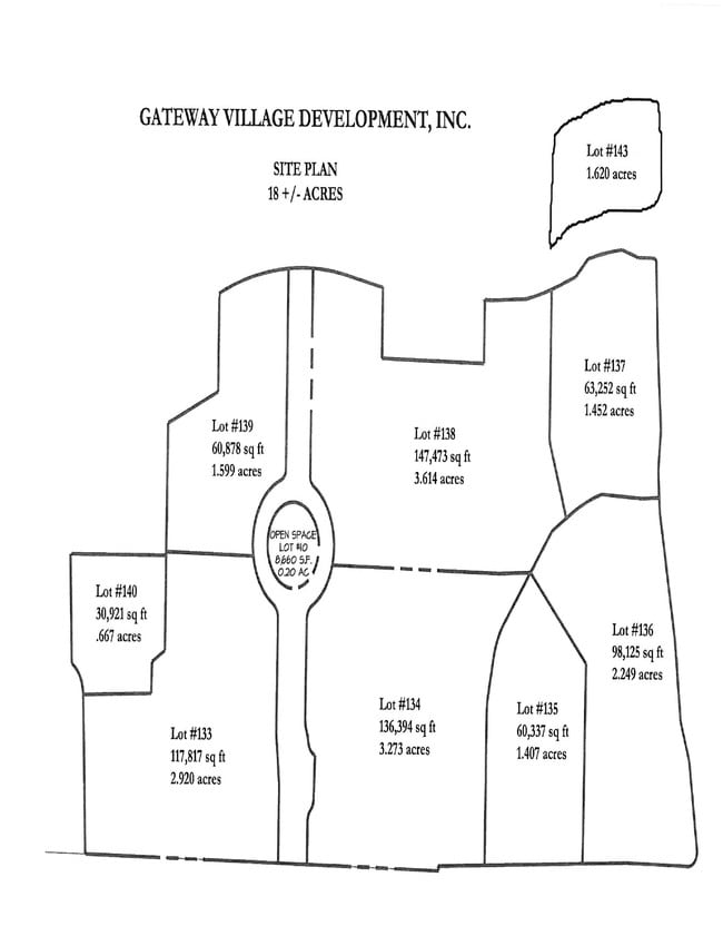
Gateway Village
036-051.05
SUBD GATEWAY VILLAGE SEC3 PB 50 PG 60 LOT 0135 SUBD GATEWAY VILLAGE SEC3 PB 69 PG 10 LOT 0135
Miscellaneous
Williamson
X
Tennessee
47187C0205F
135
2024
1.34 AC
2025
Cool Springs
050406
Nashville
20,580 SF
DEMOGRAPHICS near 1010 Perrone Way
1 Mile
3 Mile
5 Mile
2024 Total Population
4,587
31,746
98,628
2029 Population
5,268
36,315
112,714
Pop Growth 2024-2029
+ 14.85%
+ 14.39%
+ 14.28%
Average Age
44
41
41
2024 Total Households
2,247
13,141
37,755
HH Growth 2024-2029
+ 15.04%
+ 14.78%
+ 14.63%
Median Household Inc
$78,588
$97,253
$114,243
Avg Household Size
2.00
2.40
2.60
2024 Avg HH Vehicles
2.00
2.00
2.00
Median Home Value
$482,335
$647,362
$645,627
Median Year Built
1998
1995
1994
Nearby Places
- Restaurants
- Banks
- Shops
- Fitness
- Groceries
PUBLIC TRANSPORTATION
AIRPORT
Nashville International
DRIVE
WALK
Distance
Nashville International
26 min
16.9 mi
Freight Ports
Port of Mobile
DRIVE
WALK
Distance
Port of Mobile
470 min
432.5 mi
Nearby Properties
Address
Land Use
TOTAL SIZE
Lot Size
Zoning
Address
Land Use
TOTAL SIZE
Lot Size
Zoning
968,734 SF
50.12 AC
Address
Land Use
TOTAL SIZE
Lot Size
Zoning
54,218 SF
53.35 AC
Address
Land Use
TOTAL SIZE
Lot Size
Zoning
1,666,724 SF
10.29 AC
Address
Land Use
TOTAL SIZE
Lot Size
Zoning
645,388 SF
60.30 AC
Address
Land Use
TOTAL SIZE
Lot Size
Zoning
621,487 SF
5.22 AC
Address
Land Use
TOTAL SIZE
Lot Size
Zoning
534,414 SF
45.07 AC
Address
Land Use
TOTAL SIZE
Lot Size
Zoning
608,130 SF
31.50 AC
Address
Land Use
TOTAL SIZE
Lot Size
Zoning
510,452 SF
32.21 AC
Address
Land Use
TOTAL SIZE
Lot Size
Zoning
424,987 SF
28.23 AC
Address
Land Use
TOTAL SIZE
Lot Size
Zoning
416,140 SF
26.01 AC
Address
Land Use
TOTAL SIZE
Lot Size
Zoning
385,251 SF
20.56 AC
Address
Land Use
TOTAL SIZE
Lot Size
Zoning
278,442 SF
19.99 AC
Address
Land Use
TOTAL SIZE
Lot Size
Zoning
290,100 SF
7.02 AC
Address
Land Use
TOTAL SIZE
Lot Size
Zoning
614,370 SF
9.59 AC
Address
Land Use
TOTAL SIZE
Lot Size
Zoning
594,489 SF
6.18 AC
Address
Land Use
TOTAL SIZE
Lot Size
Zoning
666,185 SF
5.21 AC
Address
Land Use
TOTAL SIZE
Lot Size
Zoning
8.46 AC
Address
Land Use
TOTAL SIZE
Lot Size
Zoning
215,158 SF
4.17 AC
Address
Land Use
TOTAL SIZE
Lot Size
Zoning
391,350 SF
10.41 AC
Address
Land Use
TOTAL SIZE
Lot Size
Zoning
271,830 SF
13.99 AC
Address
Land Use
TOTAL SIZE
Lot Size
Zoning
279,457 SF
11.67 AC
Address
Land Use
TOTAL SIZE
Lot Size
Zoning
337,166 SF
23.37 AC
Address
Land Use
TOTAL SIZE
Lot Size
Zoning
175,922 SF
4.16 AC
Address
Land Use
TOTAL SIZE
Lot Size
Zoning
191,646 SF
5.21 AC
Address
Land Use
TOTAL SIZE
Lot Size
Zoning
208,640 SF
6.37 AC
Address
Land Use
TOTAL SIZE
Lot Size
Zoning
184,173 SF
25.13 AC
Address
Land Use
TOTAL SIZE
Lot Size
Zoning
255,104 SF
32.04 AC
Address
Land Use
TOTAL SIZE
Lot Size
Zoning
264,048 SF
6.51 AC
Address
Land Use
TOTAL SIZE
Lot Size
Zoning
348,230 SF
3.79 AC
Address
Land Use
TOTAL SIZE
Lot Size
Zoning
182,125 SF
13.91 AC
The World's #1 Commercial Real Estate Marketplace
Connect with us
© 2025 CoStar Group
The information above has been obtained from sources believed reliable. While we do not doubt its accuracy we have not verified it and make no guarantee, warranty or representation about it. It is your responsibility to independently confirm its accuracy and completeness. Any projections, opinions, assumptions, or estimates used are for example only and do not represent the current or future performance of the property. The value of this transaction to you depends on tax and other factors which should be evaluated by your tax, financial, and legal advisors. You and your advisors should conduct a careful, independent investigation of the property to determine to your satisfaction the suitability of the property for your needs.