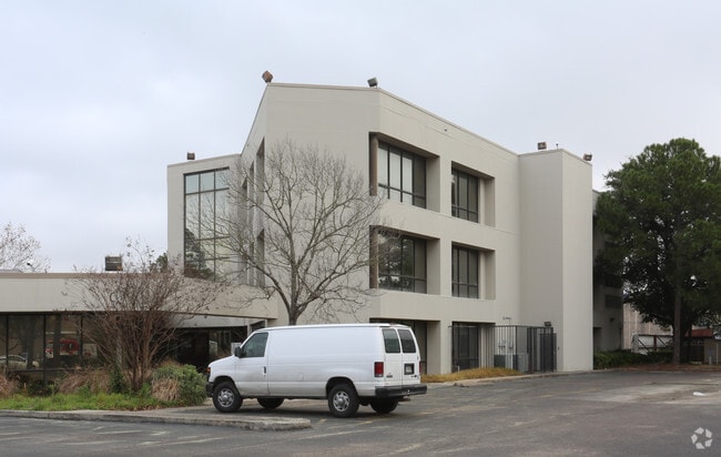
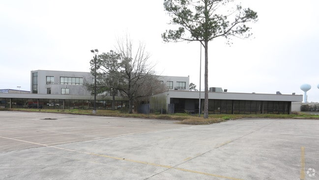
Property Record
1010 Rankin Rd, Houston, TX 77073
NEARBY LISTINGS FOR SALE OR LEASE
Property Detail
1010 Rankin Rd
Houston-The Woodlands-Sugar Land, TX
North Houston Industries Sec 1
0921270000043
TR 2C-4 NORTH HOUSTON INDUSTRIES SEC 1
Industrialacreage
Harris
X
Texas
48201C0460M
0.09 AC
2024
Greenspoint/N Belt West
2025
Houston
240506
DEMOGRAPHICS near 1010 Rankin Rd
1 Mile
3 Mile
5 Mile
2024 Total Population
11,168
86,702
205,364
2029 Population
11,461
88,538
208,704
Pop Growth 2024-2029
+ 2.62%
+ 2.12%
+ 1.63%
Average Age
31
31
33
2024 Total Households
3,635
29,435
66,226
HH Growth 2024-2029
+ 3.05%
+ 2.26%
+ 1.76%
Median Household Inc
$45,109
$37,083
$41,885
Avg Household Size
3.00
2.90
3.00
2024 Avg HH Vehicles
2.00
2.00
2.00
Median Home Value
$173,565
$152,818
$156,090
Median Year Built
2001
1987
1988
Nearby Places
Map Layers
Map Styles
 Street
 Aerial
- Restaurants
- Banks
- Shops
- Fitness
- Groceries
PUBLIC TRANSPORTATION
AIRPORT
George Bush Intcntl/Houston
DRIVE
WALK
Distance
George Bush Intcntl/Houston
10 min
6.7 mi
William P Hobby
DRIVE
WALK
Distance
William P Hobby
44 min
27.8 mi
Freight Ports
Port of Houston
DRIVE
WALK
Distance
Port of Houston
32 min
21.7 mi
SALE & LEASE HISTORY
LISTING DATE
SALE/LEASE

Nov 06, 2018
For Sale
Jun 20, 2018
For Sale
Nearby Properties
Address
Land Use
TOTAL SIZE
Lot Size
Zoning
Address
Land Use
TOTAL SIZE
Lot Size
Zoning
739,141 SF
54 AC
Address
Land Use
TOTAL SIZE
Lot Size
Zoning
413,178 SF
21.45 AC
Address
Land Use
TOTAL SIZE
Lot Size
Zoning
764,495 SF
54.15 AC
Address
Land Use
TOTAL SIZE
Lot Size
Zoning
704,105 SF
40.72 AC
Address
Land Use
TOTAL SIZE
Lot Size
Zoning
657,500 SF
36.24 AC
Address
Land Use
TOTAL SIZE
Lot Size
Zoning
790,262 SF
50.60 AC
Address
Land Use
TOTAL SIZE
Lot Size
Zoning
500,000 SF
24.58 AC
Address
Land Use
TOTAL SIZE
Lot Size
Zoning
502,325 SF
25.13 AC
Address
Land Use
TOTAL SIZE
Lot Size
Zoning
485,125 SF
28.55 AC
Address
Land Use
TOTAL SIZE
Lot Size
Zoning
276,324 SF
33.79 AC
Address
Land Use
TOTAL SIZE
Lot Size
Zoning
368,632 SF
20.06 AC
Address
Land Use
TOTAL SIZE
Lot Size
Zoning
241,625 SF
11.10 AC
Address
Land Use
TOTAL SIZE
Lot Size
Zoning
394,784 SF
22.47 AC
Address
Land Use
TOTAL SIZE
Lot Size
Zoning
350,500 SF
17.71 AC
Address
Land Use
TOTAL SIZE
Lot Size
Zoning
353,600 SF
23.45 AC
Address
Land Use
TOTAL SIZE
Lot Size
Zoning
356,622 SF
18.26 AC
Address
Land Use
TOTAL SIZE
Lot Size
Zoning
125,512 SF
18.26 AC
Address
Land Use
TOTAL SIZE
Lot Size
Zoning
423,730 SF
5.91 AC
Address
Land Use
TOTAL SIZE
Lot Size
Zoning
291,656 SF
18.94 AC
Address
Land Use
TOTAL SIZE
Lot Size
Zoning
435,650 SF
Address
Land Use
TOTAL SIZE
Lot Size
Zoning
284,687 SF
19.66 AC
Address
Land Use
TOTAL SIZE
Lot Size
Zoning
329,643 SF
19.99 AC
Address
Land Use
TOTAL SIZE
Lot Size
Zoning
57,551 SF
49.71 AC
Address
Land Use
TOTAL SIZE
Lot Size
Zoning
318,000 SF
18.53 AC
Address
Land Use
TOTAL SIZE
Lot Size
Zoning
287,251 SF
18.12 AC
Address
Land Use
TOTAL SIZE
Lot Size
Zoning
257,000 SF
13.34 AC
Address
Land Use
TOTAL SIZE
Lot Size
Zoning
288,525 SF
17.66 AC
Address
Land Use
TOTAL SIZE
Lot Size
Zoning
597,462 SF
42.07 AC
Address
Land Use
TOTAL SIZE
Lot Size
Zoning
267,158 SF
12.96 AC
Address
Land Use
TOTAL SIZE
Lot Size
Zoning
383,451 SF
15.98 AC
The World's #1 Commercial Real Estate Marketplace
Connect with us
© 2025 CoStar Group
The information above has been obtained from sources believed reliable. While we do not doubt its accuracy we have not verified it and make no guarantee, warranty or representation about it. It is your responsibility to independently confirm its accuracy and completeness. Any projections, opinions, assumptions, or estimates used are for example only and do not represent the current or future performance of the property. The value of this transaction to you depends on tax and other factors which should be evaluated by your tax, financial, and legal advisors. You and your advisors should conduct a careful, independent investigation of the property to determine to your satisfaction the suitability of the property for your needs.