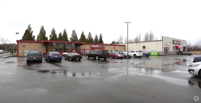
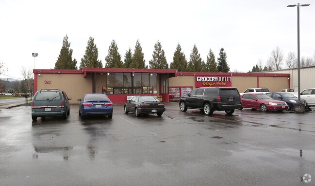
Property Record
1010 Roosevelt Ave E, Enumclaw, WA 98022

Property Detail
1010 Roosevelt Ave E
203010-0430
DICKSON O H ADD CORRECTION PLAT LESS C/M RGTS
Storebuilding
KING
HCB
Washington
A Areas with a 1% annual chance of flooding and a 26% chance of flooding over the life of a 30-year mortgage.
1-2
2025
1.84 AC
2024
E King County
031400
Seattle/Puget Sound
14,000 SF
Seattle-Tacoma-Bellevue, WA
NEARBY LISTINGS FOR SALE OR LEASE
DEMOGRAPHICS near 1010 Roosevelt Ave E
1 mile
3 mile
5 mile
2025 Total Population
9,816
19,342
28,202
2030 Population
10,271
20,166
29,256
Pop Growth 2025-2030
+ 4.64%
+ 4.26%
+ 3.74%
Average Age
40
41
42
2025 Total Households
3,920
7,488
10,697
HH Growth 2025-2030
+ 4.54%
+ 4.22%
+ 3.71%
Median Household Inc
$120,095
$120,883
$120,274
Avg Household Size
2.50
2.50
2.60
2025 Avg HH Vehicles
2.00
2.00
2.00
Median Home Value
$551,579
$607,513
$637,114
Median Year Built
1984
1983
1983
Nearby Places
Map Layers
Map Styles
 Street
 Aerial
Transit
 Traffic
 Biking
Places
Listings with unknown addresses are not visible on the map
- Restaurants
- Banks
- Shops
- Fitness
- Groceries
PUBLIC TRANSPORTATION
AIRPORT
Seattle-Tacoma International
Drive
Walk
Distance
Seattle-Tacoma International
54 min
29.5 mi
Freight Ports
Port of Tacoma
Drive
Walk
Distance
Port of Tacoma
45 min
25.6 mi
Nearby Properties
Address
Land Use
TOTAL SIZE
Lot Size
Zoning
Address
Land Use
TOTAL SIZE
Lot Size
Zoning
257,034 SF
39.18 AC
P
Address
Land Use
TOTAL SIZE
Lot Size
Zoning
240,262 SF
47.07 AC
P
Address
Land Use
TOTAL SIZE
Lot Size
Zoning
90,817 SF
3.38 AC
H
Address
Land Use
TOTAL SIZE
Lot Size
Zoning
Address
Land Use
TOTAL SIZE
Lot Size
Zoning
126,225 SF
8.42 AC
R-4
Address
Land Use
TOTAL SIZE
Lot Size
Zoning
145,161 SF
9.07 AC
LI
Address
Land Use
TOTAL SIZE
Lot Size
Zoning
33,150 SF
7.86 AC
LI
Address
Land Use
TOTAL SIZE
Lot Size
Zoning
28,384 SF
6.15 AC
P
Address
Land Use
TOTAL SIZE
Lot Size
Zoning
44,380 SF
253.26 AC
P
Address
Land Use
TOTAL SIZE
Lot Size
Zoning
100,000 SF
44.10 AC
P
Address
Land Use
TOTAL SIZE
Lot Size
Zoning
47,375 SF
40.51 AC
P
Address
Land Use
TOTAL SIZE
Lot Size
Zoning
14.27 AC
P
Address
Land Use
TOTAL SIZE
Lot Size
Zoning
65,352 SF
5.62 AC
R-4
Address
Land Use
TOTAL SIZE
Lot Size
Zoning
90,242 SF
0.21 AC
CB1
Address
Land Use
TOTAL SIZE
Lot Size
Zoning
42,444 SF
3.12 AC
R-4
Address
Land Use
TOTAL SIZE
Lot Size
Zoning
87,334 SF
33.88 AC
P
Address
Land Use
TOTAL SIZE
Lot Size
Zoning
47,992 SF
3.49 AC
NMU
Address
Land Use
TOTAL SIZE
Lot Size
Zoning
155,590 SF
63.56 AC
P
Address
Land Use
TOTAL SIZE
Lot Size
Zoning
5,870 SF
1.03 AC
LI
Address
Land Use
TOTAL SIZE
Lot Size
Zoning
60,000 SF
4.70 AC
P
Address
Land Use
TOTAL SIZE
Lot Size
Zoning
1,180 SF
2.21 AC
R-4
Address
Land Use
TOTAL SIZE
Lot Size
Zoning
39,600 SF
2.66 AC
R-4
Address
Land Use
TOTAL SIZE
Lot Size
Zoning
21,640 SF
2.42 AC
GO
Address
Land Use
TOTAL SIZE
Lot Size
Zoning
52,557 SF
3.59 AC
P
Address
Land Use
TOTAL SIZE
Lot Size
Zoning
45,007 SF
11.59 AC
P
Address
Land Use
TOTAL SIZE
Lot Size
Zoning
33,280 SF
2.79 AC
R-4
Address
Land Use
TOTAL SIZE
Lot Size
Zoning
2.39 AC
LI
Address
Land Use
TOTAL SIZE
Lot Size
Zoning
56,514 SF
3.66 AC
HCB
Address
Land Use
TOTAL SIZE
Lot Size
Zoning
44,284 SF
4.31 AC
HCB
Address
Land Use
TOTAL SIZE
Lot Size
Zoning
30,692 SF
4.58 AC
P
The World's #1 Commercial Real Estate Marketplace
Connect with us
© 2026 CoStar Group
The information above has been obtained from sources believed reliable. While we do not doubt its accuracy we have not verified it and make no guarantee, warranty or representation about it. It is your responsibility to independently confirm its accuracy and completeness. Any projections, opinions, assumptions, or estimates used are for example only and do not represent the current or future performance of the property. The value of this transaction to you depends on tax and other factors which should be evaluated by your tax, financial, and legal advisors. You and your advisors should conduct a careful, independent investigation of the property to determine to your satisfaction the suitability of the property for your needs.