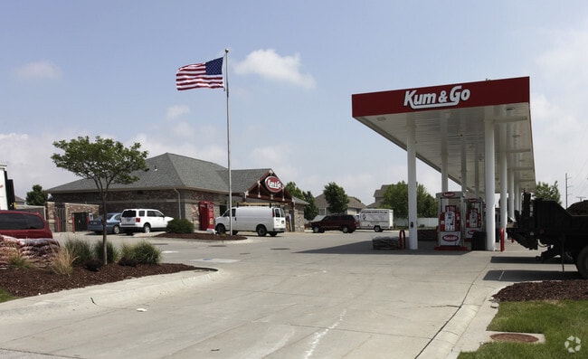
Property Record
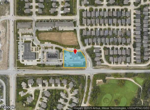
1010 S 189Th St, Elkhorn, NE 68022
NEARBY LISTINGS FOR SALE OR LEASE
Property Detail
1010 S 189Th St
Omaha-Council Bluffs, NE-IA
Grove
2212-5132-12
GROVE THE REPLAT 9 LOT 2 BLOCK 0 IRREG 51328 SQ FT
Storebuilding
Douglas
X
Nebraska
31153C0030H
2
2024
1.18 AC
2025
Southwest Omaha
007524
Omaha/Council Bluffs
3,290 SF
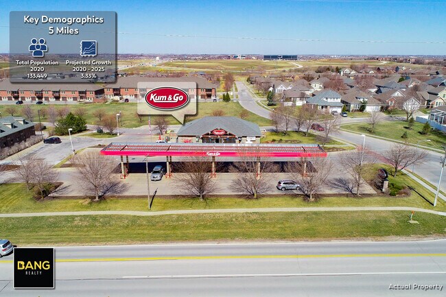
DEMOGRAPHICS near 1010 S 189Th St
1 Mile
3 Mile
5 Mile
2024 Total Population
9,162
65,849
163,405
2029 Population
9,227
66,811
166,293
Pop Growth 2024-2029
+ 0.71%
+ 1.46%
+ 1.77%
Average Age
38
38
38
2024 Total Households
3,210
23,728
59,003
HH Growth 2024-2029
+ 0.65%
+ 1.48%
+ 1.69%
Median Household Inc
$162,112
$127,541
$115,726
Avg Household Size
2.80
2.70
2.70
2024 Avg HH Vehicles
2.00
2.00
2.00
Median Home Value
$406,033
$350,864
$297,643
Median Year Built
2007
2003
1999
Nearby Places
Map Layers
Map Styles
 Street
 Aerial
- Restaurants
- Banks
- Shops
- Fitness
- Groceries
PUBLIC TRANSPORTATION
AIRPORT
Eppley Airfield
DRIVE
WALK
Distance
Eppley Airfield
37 min
19.7 mi
Freight Ports
Tulsa Port Of Catoosa
DRIVE
WALK
Distance
Tulsa Port Of Catoosa
483 min
430.9 mi
SALE & LEASE HISTORY
LISTING DATE
SALE/LEASE

May 14, 2020
For Sale
Mar 30, 2021
For Sale
Mar 23, 2018
For Sale
Jun 15, 2018
For Sale
Jan 15, 2019
For Sale
Jan 15, 2019
For Sale
Jan 10, 2019
For Sale
Nearby Properties
Address
Land Use
TOTAL SIZE
Lot Size
Zoning
Address
Land Use
TOTAL SIZE
Lot Size
Zoning
443,045 SF
22.82 AC
Address
Land Use
TOTAL SIZE
Lot Size
Zoning
486,568 SF
51.70 AC
ELKHORN
Address
Land Use
TOTAL SIZE
Lot Size
Zoning
391,191 SF
87.18 AC
GI
Address
Land Use
TOTAL SIZE
Lot Size
Zoning
449,891 SF
11.32 AC
Address
Land Use
TOTAL SIZE
Lot Size
Zoning
410,657 SF
18.25 AC
Address
Land Use
TOTAL SIZE
Lot Size
Zoning
362,573 SF
2.01 AC
Address
Land Use
TOTAL SIZE
Lot Size
Zoning
223,975 SF
11.91 AC
Address
Land Use
TOTAL SIZE
Lot Size
Zoning
369,614 SF
18.03 AC
CC
Address
Land Use
TOTAL SIZE
Lot Size
Zoning
299,172 SF
13.80 AC
R7
Address
Land Use
TOTAL SIZE
Lot Size
Zoning
264,001 SF
10.33 AC
Address
Land Use
TOTAL SIZE
Lot Size
Zoning
114,840 SF
4.50 AC
Address
Land Use
TOTAL SIZE
Lot Size
Zoning
104,473 SF
0.78 AC
MU
Address
Land Use
TOTAL SIZE
Lot Size
Zoning
240,630 SF
5.38 AC
Address
Land Use
TOTAL SIZE
Lot Size
Zoning
241,312 SF
14.51 AC
Address
Land Use
TOTAL SIZE
Lot Size
Zoning
226,792 SF
8.97 AC
GO
Address
Land Use
TOTAL SIZE
Lot Size
Zoning
88,928 SF
6.17 AC
Address
Land Use
TOTAL SIZE
Lot Size
Zoning
226,780 SF
8.23 AC
Address
Land Use
TOTAL SIZE
Lot Size
Zoning
341,379 SF
18.08 AC
Address
Land Use
TOTAL SIZE
Lot Size
Zoning
232,559 SF
13.53 AC
R6
Address
Land Use
TOTAL SIZE
Lot Size
Zoning
215,645 SF
5.19 AC
Address
Land Use
TOTAL SIZE
Lot Size
Zoning
233,520 SF
15.39 AC
Address
Land Use
TOTAL SIZE
Lot Size
Zoning
355,421 SF
18.66 AC
Address
Land Use
TOTAL SIZE
Lot Size
Zoning
121,017 SF
13.23 AC
Address
Land Use
TOTAL SIZE
Lot Size
Zoning
222,090 SF
7.74 AC
R6
Address
Land Use
TOTAL SIZE
Lot Size
Zoning
144,271 SF
4.75 AC
Address
Land Use
TOTAL SIZE
Lot Size
Zoning
137,800 SF
6.69 AC
Address
Land Use
TOTAL SIZE
Lot Size
Zoning
143,817 SF
12.27 AC
Address
Land Use
TOTAL SIZE
Lot Size
Zoning
149,113 SF
7.64 AC
R6
Address
Land Use
TOTAL SIZE
Lot Size
Zoning
99,347 SF
4.50 AC
Address
Land Use
TOTAL SIZE
Lot Size
Zoning
96,764 SF
5.48 AC
MU
The World's #1 Commercial Real Estate Marketplace
Connect with us
© 2025 CoStar Group
The information above has been obtained from sources believed reliable. While we do not doubt its accuracy we have not verified it and make no guarantee, warranty or representation about it. It is your responsibility to independently confirm its accuracy and completeness. Any projections, opinions, assumptions, or estimates used are for example only and do not represent the current or future performance of the property. The value of this transaction to you depends on tax and other factors which should be evaluated by your tax, financial, and legal advisors. You and your advisors should conduct a careful, independent investigation of the property to determine to your satisfaction the suitability of the property for your needs.