Property Record
1010 S Eugene St, Greensboro, NC 27406
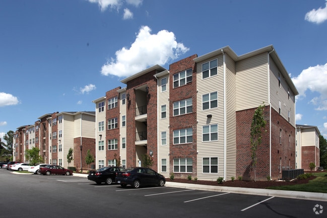

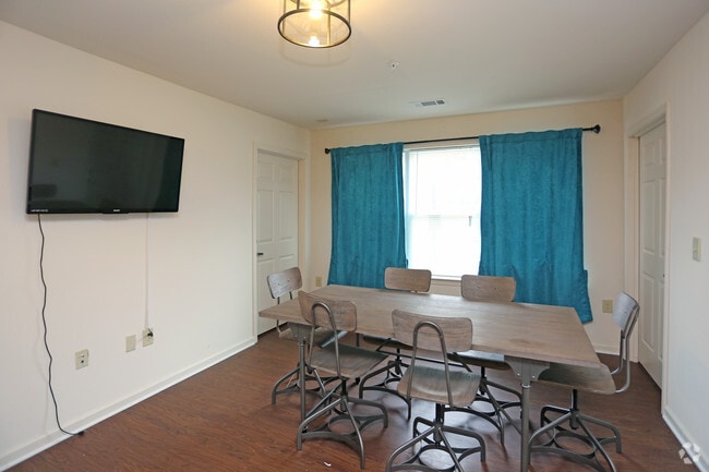
Property Detail
1010 S Eugene St
0003390
THE RESERVE/CAMPUS CREST LO:2
Apartment
GUILFORD
PI
North Carolina
B and X Area of moderate flood hazard, usually the area between the limits of the 100-year and 500-year floods.
2
2024
17.51 AC
2025
Warnersville
012804
Greensboro/Winston-Salem
291,464 SF
Greensboro-High Point, NC
NEARBY LISTINGS FOR SALE OR LEASE
DEMOGRAPHICS near 1010 S Eugene St
1 mile
3 mile
5 mile
2025 Total Population
20,883
93,386
202,796
2030 Population
21,601
96,647
209,332
Pop Growth 2025-2030
+ 3.44%
+ 3.49%
+ 3.22%
Average Age
30
35
37
2025 Total Households
6,247
34,402
80,272
HH Growth 2025-2030
+ 4.39%
+ 3.93%
+ 3.51%
Median Household Inc
$43,817
$51,764
$54,396
Avg Household Size
2.00
2.20
2.30
2025 Avg HH Vehicles
1.00
2.00
2.00
Median Home Value
$220,072
$223,838
$239,884
Median Year Built
1970
1967
1975
Nearby Places
Map Layers
Map Styles
 Street
 Aerial
Layers
 Traffic
 Biking
Places
Listings with unknown addresses are not visible on the map
- Restaurants
- Banks
- Shops
- Fitness
- Groceries
PUBLIC TRANSPORTATION
COMMUTER RAIL
Greensboro Station (Piedmont - North Carolina by Train (NC Train))
Drive
Walk
Distance
Greensboro Station (Piedmont - North Carolina by Train (NC Train))
2 min
16 min
0.8 mi
AIRPORT
Piedmont Triad International
Drive
Walk
Distance
Piedmont Triad International
22 min
11.3 mi
Freight Ports
Virginia Port Authority - Richmond
Drive
Walk
Distance
Virginia Port Authority - Richmond
229 min
197.7 mi
Nearby Properties
Address
Land Use
TOTAL SIZE
Lot Size
Zoning
Address
Land Use
TOTAL SIZE
Lot Size
Zoning
908,421 SF
62.30 AC
PI
Address
Land Use
TOTAL SIZE
Lot Size
Zoning
1,864,781 SF
96.17 AC
PI
Address
Land Use
TOTAL SIZE
Lot Size
Zoning
671,937 SF
44.01 AC
PI
Address
Land Use
TOTAL SIZE
Lot Size
Zoning
593,135 SF
26.07 AC
PI
Address
Land Use
TOTAL SIZE
Lot Size
Zoning
646,229 SF
25.47 AC
LI
Address
Land Use
TOTAL SIZE
Lot Size
Zoning
905,672 SF
28.64 AC
PI
Address
Land Use
TOTAL SIZE
Lot Size
Zoning
733,612 SF
19.38 AC
PI
Address
Land Use
TOTAL SIZE
Lot Size
Zoning
388,224 SF
0.98 AC
CB
Address
Land Use
TOTAL SIZE
Lot Size
Zoning
356,139 SF
0.99 AC
CB
Address
Land Use
TOTAL SIZE
Lot Size
Zoning
549,907 SF
43.02 AC
C-H
Address
Land Use
TOTAL SIZE
Lot Size
Zoning
957,290 SF
18.71 AC
C-H
Address
Land Use
TOTAL SIZE
Lot Size
Zoning
570,402 SF
33.42 AC
RM-18
Address
Land Use
TOTAL SIZE
Lot Size
Zoning
2.09 AC
CB
Address
Land Use
TOTAL SIZE
Lot Size
Zoning
352,060 SF
3.67 AC
CB
Address
Land Use
TOTAL SIZE
Lot Size
Zoning
364,370 SF
1.85 AC
CB
Address
Land Use
TOTAL SIZE
Lot Size
Zoning
303,490 SF
1.29 AC
CB
Address
Land Use
TOTAL SIZE
Lot Size
Zoning
275,122 SF
0.76 AC
CB
Address
Land Use
TOTAL SIZE
Lot Size
Zoning
413,840 SF
3.68 AC
PI
Address
Land Use
TOTAL SIZE
Lot Size
Zoning
446,318 SF
125.67 AC
LI
Address
Land Use
TOTAL SIZE
Lot Size
Zoning
342,490 SF
17.99 AC
PI
Address
Land Use
TOTAL SIZE
Lot Size
Zoning
228,253 SF
11.21 AC
RM-18
Address
Land Use
TOTAL SIZE
Lot Size
Zoning
287,581 SF
39.35 AC
PI
Address
Land Use
TOTAL SIZE
Lot Size
Zoning
361,604 SF
16.55 AC
RM-18
Address
Land Use
TOTAL SIZE
Lot Size
Zoning
163,439 SF
4.01 AC
CB
Address
Land Use
TOTAL SIZE
Lot Size
Zoning
321,985 SF
4.80 AC
C-H
Address
Land Use
TOTAL SIZE
Lot Size
Zoning
358,324 SF
4.02 AC
PUD
Address
Land Use
TOTAL SIZE
Lot Size
Zoning
163,346 SF
0.92 AC
CB
Address
Land Use
TOTAL SIZE
Lot Size
Zoning
249,779 SF
2.83 AC
CB
Address
Land Use
TOTAL SIZE
Lot Size
Zoning
170,200 SF
1.05 AC
CB
The World's #1 Commercial Real Estate Marketplace
Connect with us
© 2026 CoStar Group
The information above has been obtained from sources believed reliable. While we do not doubt its accuracy we have not verified it and make no guarantee, warranty or representation about it. It is your responsibility to independently confirm its accuracy and completeness. Any projections, opinions, assumptions, or estimates used are for example only and do not represent the current or future performance of the property. The value of this transaction to you depends on tax and other factors which should be evaluated by your tax, financial, and legal advisors. You and your advisors should conduct a careful, independent investigation of the property to determine to your satisfaction the suitability of the property for your needs.