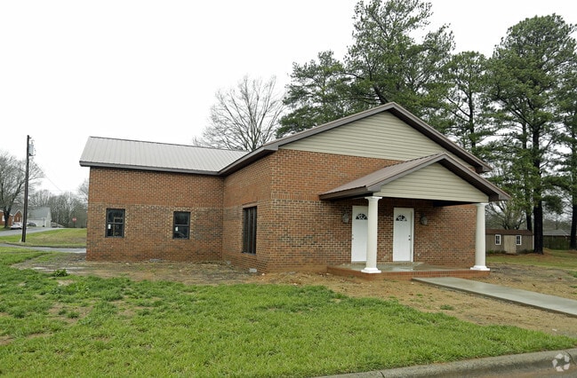
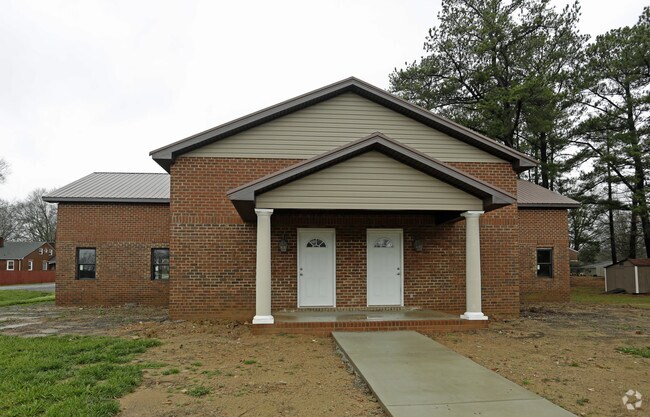
Property Record
1010 S Main St, Landis, NC 28088

Property Detail
1010 S Main St
157-061
L7-8 BH L. A. CORRIHER ADDITION TO LANDIS
Multifamilydwelling
Rowan
OI:OFFICE
North Carolina
B and X Area of moderate flood hazard, usually the area between the limits of the 100-year and 500-year floods.
0.46 AC
2025
Rowan County
2025
Charlotte
051600
Charlotte-Concord-Gastonia, NC-SC
2,350 SF
NEARBY LISTINGS FOR SALE OR LEASE
DEMOGRAPHICS near 1010 S Main St
1 mile
3 mile
5 mile
2025 Total Population
4,884
29,789
66,876
2030 Population
5,137
31,441
70,974
Pop Growth 2025-2030
+ 5.18%
+ 5.55%
+ 6.13%
Average Age
39
39
40
2025 Total Households
1,921
11,777
26,237
HH Growth 2025-2030
+ 5.31%
+ 5.67%
+ 6.29%
Median Household Inc
$58,873
$63,595
$60,568
Avg Household Size
2.50
2.50
2.50
2025 Avg HH Vehicles
2.00
2.00
2.00
Median Home Value
$287,104
$250,176
$256,289
Median Year Built
1977
1974
1979
Nearby Places
Map Layers
Map Styles
 Street
 Aerial
Layers
 Traffic
 Biking
Places
Listings with unknown addresses are not visible on the map
- Restaurants
- Banks
- Shops
- Fitness
- Groceries
PUBLIC TRANSPORTATION
COMMUTER RAIL
Kannapolis Station (Piedmont - North Carolina by Train (NC Train))
Drive
Walk
Distance
Kannapolis Station (Piedmont - North Carolina by Train (NC Train))
6 min
3.2 mi
AIRPORT
Concord-Padgett Regional
Drive
Walk
Distance
Concord-Padgett Regional
26 min
15.9 mi
Charlotte/Douglas International
Drive
Walk
Distance
Charlotte/Douglas International
52 min
36.2 mi
SALE & LEASE HISTORY
LISTING DATE
SALE/LEASE

Sep 24, 2016
For Sale
Jul 28, 2017
For Sale
Jul 25, 2017
For Sale
Feb 28, 2017
For Sale
Nearby Properties
Address
Land Use
TOTAL SIZE
Lot Size
Zoning
Address
Land Use
TOTAL SIZE
Lot Size
Zoning
276,070 SF
CC
Address
Land Use
TOTAL SIZE
Lot Size
Zoning
728,000 SF
51.80 AC
Address
Land Use
TOTAL SIZE
Lot Size
Zoning
128,064 SF
2.68 AC
CC
Address
Land Use
TOTAL SIZE
Lot Size
Zoning
121,156 SF
3.57 AC
CC
Address
Land Use
TOTAL SIZE
Lot Size
Zoning
106,804 SF
1.81 AC
CC
Address
Land Use
TOTAL SIZE
Lot Size
Zoning
83,152 SF
7.11 AC
CC
Address
Land Use
TOTAL SIZE
Lot Size
Zoning
176,075 SF
2.35 AC
CC
Address
Land Use
TOTAL SIZE
Lot Size
Zoning
85,422 SF
6.30 AC
R8
Address
Land Use
TOTAL SIZE
Lot Size
Zoning
67,862 SF
1.77 AC
CC
Address
Land Use
TOTAL SIZE
Lot Size
Zoning
55,888 SF
39.43 AC
Address
Land Use
TOTAL SIZE
Lot Size
Zoning
12,010 SF
0.40 AC
CC
Address
Land Use
TOTAL SIZE
Lot Size
Zoning
66,194 SF
2.94 AC
CC
Address
Land Use
TOTAL SIZE
Lot Size
Zoning
101,014 SF
1.84 AC
CC
Address
Land Use
TOTAL SIZE
Lot Size
Zoning
56,923 SF
2 AC
CC
Address
Land Use
TOTAL SIZE
Lot Size
Zoning
64,554 SF
2.67 AC
CC
Address
Land Use
TOTAL SIZE
Lot Size
Zoning
115,509 SF
4.90 AC
R8
Address
Land Use
TOTAL SIZE
Lot Size
Zoning
12,415 SF
25.46 AC
R8
Address
Land Use
TOTAL SIZE
Lot Size
Zoning
269,700 SF
76.24 AC
Address
Land Use
TOTAL SIZE
Lot Size
Zoning
78,771 SF
CC
Address
Land Use
TOTAL SIZE
Lot Size
Zoning
50,366 SF
1.64 AC
CC
Address
Land Use
TOTAL SIZE
Lot Size
Zoning
175,140 SF
1.12 AC
CC
Address
Land Use
TOTAL SIZE
Lot Size
Zoning
35,850 SF
34 AC
Address
Land Use
TOTAL SIZE
Lot Size
Zoning
48,024 SF
5.26 AC
O-I
Address
Land Use
TOTAL SIZE
Lot Size
Zoning
1,545 SF
0.56 AC
CC
Address
Land Use
TOTAL SIZE
Lot Size
Zoning
83,701 SF
2.99 AC
R4
Address
Land Use
TOTAL SIZE
Lot Size
Zoning
21,906 SF
7.50 AC
OI:OFFICE
Address
Land Use
TOTAL SIZE
Lot Size
Zoning
89,623 SF
7.58 AC
CC
Address
Land Use
TOTAL SIZE
Lot Size
Zoning
37,300 SF
20.95 AC
RM2:MULTI
Address
Land Use
TOTAL SIZE
Lot Size
Zoning
39.58 AC
CC
Address
Land Use
TOTAL SIZE
Lot Size
Zoning
44,149 SF
11.26 AC
The World's #1 Commercial Real Estate Marketplace
Connect with us
© 2026 CoStar Group
The information above has been obtained from sources believed reliable. While we do not doubt its accuracy we have not verified it and make no guarantee, warranty or representation about it. It is your responsibility to independently confirm its accuracy and completeness. Any projections, opinions, assumptions, or estimates used are for example only and do not represent the current or future performance of the property. The value of this transaction to you depends on tax and other factors which should be evaluated by your tax, financial, and legal advisors. You and your advisors should conduct a careful, independent investigation of the property to determine to your satisfaction the suitability of the property for your needs.