Property Record
1010 S Nova Rd, Ormond Beach, FL 32174
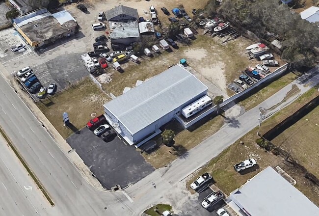

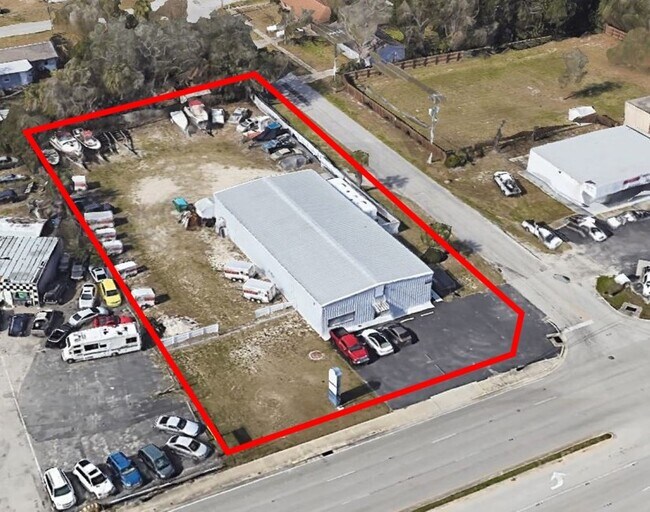
This Property Is For Sale
Property Detail
1010 S Nova Rd
4242-04-20-0140
N 135 FT OF LOT 14 EXC E PART IN HWY & EXC CORNER FOR NEW R/W MEAS 21.94 FT ON N/L BLK 20 FLEMING FITCH GRANT MB 1 PG 1 PER OR 2060 PG 0126 PER OR 6022 PG 3124 PER OR 7542 PG 4329
Officebuilding
Volusia
01I1
Florida
B and X Area of moderate flood hazard, usually the area between the limits of the 100-year and 500-year floods.
14
2025
0.75 AC
2026
North Daytona Beach
080805
Deltona/Daytona Beach
5,000 SF
Deltona-Daytona Beach-Ormond Beach, FL
NEARBY LISTINGS FOR SALE OR LEASE
DEMOGRAPHICS near 1010 S Nova Rd
1 mile
3 mile
5 mile
2025 Total Population
10,590
66,553
128,851
2030 Population
11,282
71,791
139,952
Pop Growth 2025-2030
+ 6.53%
+ 7.87%
+ 8.62%
Average Age
43
46
45
2025 Total Households
4,561
29,748
56,655
HH Growth 2025-2030
+ 6.47%
+ 7.97%
+ 8.74%
Median Household Inc
$50,764
$54,314
$56,957
Avg Household Size
2.20
2.10
2.10
2025 Avg HH Vehicles
2.00
2.00
2.00
Median Home Value
$168,443
$284,581
$333,924
Median Year Built
1984
1980
1980
Nearby Places
Map Layers
Map Styles
 Street
 Aerial
Layers
 Traffic
 Biking
Places
Listings with unknown addresses are not visible on the map
- Restaurants
- Banks
- Shops
- Fitness
- Groceries
PUBLIC TRANSPORTATION
AIRPORT
Daytona Beach International
Drive
Walk
Distance
Daytona Beach International
16 min
8.2 mi
Freight Ports
Port Canaveral
Drive
Walk
Distance
Port Canaveral
93 min
77.8 mi
Nearby Properties
Address
Land Use
TOTAL SIZE
Lot Size
Zoning
Address
Land Use
TOTAL SIZE
Lot Size
Zoning
849,735 SF
140.62 AC
01A2
Address
Land Use
TOTAL SIZE
Lot Size
Zoning
437,897 SF
28.94 AC
Address
Land Use
TOTAL SIZE
Lot Size
Zoning
451,526 SF
17.96 AC
Address
Land Use
TOTAL SIZE
Lot Size
Zoning
293,850 SF
29.38 AC
Address
Land Use
TOTAL SIZE
Lot Size
Zoning
491,161 SF
31 AC
Address
Land Use
TOTAL SIZE
Lot Size
Zoning
12,394 SF
139.59 AC
Address
Land Use
TOTAL SIZE
Lot Size
Zoning
135,122 SF
78 AC
Address
Land Use
TOTAL SIZE
Lot Size
Zoning
470,843 SF
1.78 AC
RC
Address
Land Use
TOTAL SIZE
Lot Size
Zoning
10,637 SF
0.15 AC
R2
Address
Land Use
TOTAL SIZE
Lot Size
Zoning
307,322 SF
65.41 AC
Address
Land Use
TOTAL SIZE
Lot Size
Zoning
409,718 SF
12.86 AC
Address
Land Use
TOTAL SIZE
Lot Size
Zoning
434,487 SF
20.54 AC
Address
Land Use
TOTAL SIZE
Lot Size
Zoning
425,548 SF
10.16 AC
Address
Land Use
TOTAL SIZE
Lot Size
Zoning
375,572 SF
0.13 AC
R2
Address
Land Use
TOTAL SIZE
Lot Size
Zoning
359,180 SF
29.73 AC
01A2
Address
Land Use
TOTAL SIZE
Lot Size
Zoning
417,015 SF
27.55 AC
Address
Land Use
TOTAL SIZE
Lot Size
Zoning
333,708 SF
0.24 AC
01A2
Address
Land Use
TOTAL SIZE
Lot Size
Zoning
318,707 SF
12.16 AC
Address
Land Use
TOTAL SIZE
Lot Size
Zoning
300,760 SF
20.75 AC
Address
Land Use
TOTAL SIZE
Lot Size
Zoning
346,734 SF
14 AC
Address
Land Use
TOTAL SIZE
Lot Size
Zoning
158,299 SF
22 AC
Address
Land Use
TOTAL SIZE
Lot Size
Zoning
259,453 SF
2.07 AC
Address
Land Use
TOTAL SIZE
Lot Size
Zoning
403,130 SF
28.45 AC
Address
Land Use
TOTAL SIZE
Lot Size
Zoning
180,767 SF
27.05 AC
13R6
Address
Land Use
TOTAL SIZE
Lot Size
Zoning
60,873 SF
8.82 AC
Address
Land Use
TOTAL SIZE
Lot Size
Zoning
184,301 SF
50.28 AC
Address
Land Use
TOTAL SIZE
Lot Size
Zoning
5,426 SF
6.28 AC
09R9
Address
Land Use
TOTAL SIZE
Lot Size
Zoning
184,829 SF
9.71 AC
01A2
Address
Land Use
TOTAL SIZE
Lot Size
Zoning
56,220 SF
13.13 AC
Address
Land Use
TOTAL SIZE
Lot Size
Zoning
168,456 SF
15.74 AC
The World's #1 Commercial Real Estate Marketplace
Connect with us
© 2026 CoStar Group
The information above has been obtained from sources believed reliable. While we do not doubt its accuracy we have not verified it and make no guarantee, warranty or representation about it. It is your responsibility to independently confirm its accuracy and completeness. Any projections, opinions, assumptions, or estimates used are for example only and do not represent the current or future performance of the property. The value of this transaction to you depends on tax and other factors which should be evaluated by your tax, financial, and legal advisors. You and your advisors should conduct a careful, independent investigation of the property to determine to your satisfaction the suitability of the property for your needs.