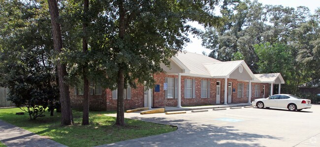
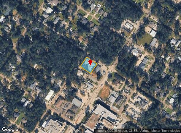
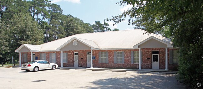
Property Record
1010 S Polk St, Covington, LA 70433
NEARBY LISTINGS FOR SALE OR LEASE
Property Detail
1010 S Polk St
Slidell-Mandeville-Covington, LA
Commercial Div Of New Cov
21209
LOT 2B SQ 1111 DIVISION OF NEW COVINGTON CB 747 966 CB 963 887 INST NO 1132341 INST NO 1951828
Commercialnec
St Tammany
ARE
Louisiana
2025
2b
2024
0.43 AC
040402
Mandeville/Covington
5,775 SF
New Orleans/Metairie/Kenner
DEMOGRAPHICS near 1010 S Polk St
1 mile
3 mile
5 mile
2024 Total Population
4,982
33,420
73,136
2029 Population
5,368
36,181
78,783
Pop Growth 2024-2029
+ 7.75%
+ 8.26%
+ 7.72%
Average Age
43
41
41
2024 Total Households
2,135
13,545
28,903
HH Growth 2024-2029
+ 7.78%
+ 8.25%
+ 7.71%
Median Household Inc
$76,762
$72,953
$74,697
Avg Household Size
2.30
2.40
2.50
2024 Avg HH Vehicles
2.00
2.00
2.00
Median Home Value
$360,742
$325,965
$293,904
Median Year Built
1984
2000
1998
Nearby Places
Map Layers
Map Styles
 Street
 Aerial
Transit
 Traffic
 Biking
Places
Listings with unknown addresses are not visible on the map
- Restaurants
- Banks
- Shops
- Fitness
- Groceries
PUBLIC TRANSPORTATION
AIRPORT
Louis Armstrong New Orleans International
Drive
Walk
Distance
Louis Armstrong New Orleans International
59 min
43.3 mi
Freight Ports
Port of New Orleans
Drive
Walk
Distance
Port of New Orleans
63 min
44.3 mi
Nearby Properties
Address
Land Use
TOTAL SIZE
Lot Size
Zoning
Address
Land Use
TOTAL SIZE
Lot Size
Zoning
515,547 SF
20.54 AC
Address
Land Use
TOTAL SIZE
Lot Size
Zoning
13.36 AC
Address
Land Use
TOTAL SIZE
Lot Size
Zoning
285,406 SF
Address
Land Use
TOTAL SIZE
Lot Size
Zoning
278,202 SF
12.04 AC
Address
Land Use
TOTAL SIZE
Lot Size
Zoning
179,934 SF
20.43 AC
Address
Land Use
TOTAL SIZE
Lot Size
Zoning
200,000 SF
0.28 AC
Address
Land Use
TOTAL SIZE
Lot Size
Zoning
5.10 AC
Address
Land Use
TOTAL SIZE
Lot Size
Zoning
6.21 AC
Address
Land Use
TOTAL SIZE
Lot Size
Zoning
277,159 SF
55.30 AC
Address
Land Use
TOTAL SIZE
Lot Size
Zoning
121,800 SF
15.15 AC
Address
Land Use
TOTAL SIZE
Lot Size
Zoning
Address
Land Use
TOTAL SIZE
Lot Size
Zoning
24.12 AC
Address
Land Use
TOTAL SIZE
Lot Size
Zoning
246,559 SF
42.43 AC
Address
Land Use
TOTAL SIZE
Lot Size
Zoning
105,000 SF
9.37 AC
Address
Land Use
TOTAL SIZE
Lot Size
Zoning
96,067 SF
10.71 AC
Address
Land Use
TOTAL SIZE
Lot Size
Zoning
86,167 SF
0.71 AC
Address
Land Use
TOTAL SIZE
Lot Size
Zoning
99,157 SF
12 AC
Address
Land Use
TOTAL SIZE
Lot Size
Zoning
147,767 SF
35.97 AC
Address
Land Use
TOTAL SIZE
Lot Size
Zoning
171,138 SF
13.02 AC
Address
Land Use
TOTAL SIZE
Lot Size
Zoning
66,500 SF
4.35 AC
Address
Land Use
TOTAL SIZE
Lot Size
Zoning
77,245 SF
5.58 AC
Address
Land Use
TOTAL SIZE
Lot Size
Zoning
77,994 SF
5.29 AC
Address
Land Use
TOTAL SIZE
Lot Size
Zoning
102,470 SF
10.50 AC
Address
Land Use
TOTAL SIZE
Lot Size
Zoning
205,612 SF
23.60 AC
Address
Land Use
TOTAL SIZE
Lot Size
Zoning
147,611 SF
22 AC
Address
Land Use
TOTAL SIZE
Lot Size
Zoning
38,976 SF
6.80 AC
Address
Land Use
TOTAL SIZE
Lot Size
Zoning
154,208 SF
21.28 AC
Address
Land Use
TOTAL SIZE
Lot Size
Zoning
82,796 SF
19.47 AC
Address
Land Use
TOTAL SIZE
Lot Size
Zoning
107,727 SF
2.69 AC
Address
Land Use
TOTAL SIZE
Lot Size
Zoning
92,535 SF
2.80 AC
The World's #1 Commercial Real Estate Marketplace
Connect with us
© 2026 CoStar Group
The information above has been obtained from sources believed reliable. While we do not doubt its accuracy we have not verified it and make no guarantee, warranty or representation about it. It is your responsibility to independently confirm its accuracy and completeness. Any projections, opinions, assumptions, or estimates used are for example only and do not represent the current or future performance of the property. The value of this transaction to you depends on tax and other factors which should be evaluated by your tax, financial, and legal advisors. You and your advisors should conduct a careful, independent investigation of the property to determine to your satisfaction the suitability of the property for your needs.