Property Record
1010 W 24Th Ave, Bellevue, NE 68005


Save to a Folder
{{folder.Name}}
{{folder.ListingIds.length}} Properties
{{folder.ListingIds.length}} Property
Create a New Folder
Property Detail
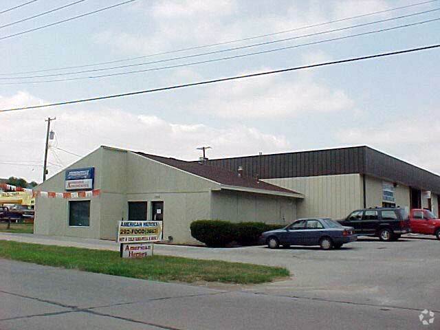
1010 W 24Th Ave
Omaha, NE-IA
LOT 1 MILLERS ADDITION & VAC ALLEY ADJ
011137010
Sarpy
Industrialgeneral
Nebraska
B and X Area of moderate flood hazard, usually the area between the limits of the 100-year and 500-year floods.
1
2024
0.68 AC
2025
Sarpy East
010402
Omaha/Council Bluffs
8,358 SF
NEARBY LISTINGS FOR SALE OR LEASE
-
-
View all Bellevue listings for sale on LoopNet.com
DEMOGRAPHICS near 1010 W 24Th Ave
1 mile
3 mile
5 mile
2025 Total Population
10,912
39,710
81,718
2030 Population
11,551
42,079
86,617
Pop Growth 2025-2030
+ 5.86%
+ 5.97%
+ 6.00%
Average Age
38
38
37
2025 Total Households
4,405
15,791
30,534
HH Growth 2025-2030
+ 6.20%
+ 6.28%
+ 6.31%
Median Household Inc
$63,650
$80,938
$89,227
Avg Household Size
2.30
2.40
2.60
2025 Avg HH Vehicles
2.00
2.00
2.00
Median Home Value
$169,835
$252,387
$268,790
Median Year Built
1965
1979
1985
Nearby Places
Map Layers
Map Styles
 Street
 Aerial
Layers
 Traffic
 Biking
Places
Listings with unknown addresses are not visible on the map
- Restaurants
- Banks
- Shops
- Fitness
- Groceries
PUBLIC TRANSPORTATION
AIRPORT
Eppley Airfield
Drive
Walk
Distance
Eppley Airfield
25 min
14.5 mi
Freight Ports
Tulsa Port Of Catoosa
Drive
Walk
Distance
Tulsa Port Of Catoosa
454 min
408.3 mi
Nearby Properties
Address
Land Use
TOTAL SIZE
Lot Size
Zoning
Address
Land Use
TOTAL SIZE
Lot Size
Zoning
272,760 SF
2.40 AC
Address
Land Use
TOTAL SIZE
Lot Size
Zoning
17,155 SF
13.11 AC
Address
Land Use
TOTAL SIZE
Lot Size
Zoning
24,969 SF
3.79 AC
RG20
Address
Land Use
TOTAL SIZE
Lot Size
Zoning
10,052 SF
9.38 AC
Address
Land Use
TOTAL SIZE
Lot Size
Zoning
160,000 SF
22.48 AC
Address
Land Use
TOTAL SIZE
Lot Size
Zoning
254,734 SF
18.90 AC
Address
Land Use
TOTAL SIZE
Lot Size
Zoning
1,216 SF
22.82 AC
Address
Land Use
TOTAL SIZE
Lot Size
Zoning
2,440 SF
18.88 AC
RG28
Address
Land Use
TOTAL SIZE
Lot Size
Zoning
18,825 SF
15.18 AC
Address
Land Use
TOTAL SIZE
Lot Size
Zoning
117,829 SF
11.13 AC
BG
Address
Land Use
TOTAL SIZE
Lot Size
Zoning
119,396 SF
13.46 AC
Address
Land Use
TOTAL SIZE
Lot Size
Zoning
226,320 SF
12.75 AC
Address
Land Use
TOTAL SIZE
Lot Size
Zoning
3.95 AC
Address
Land Use
TOTAL SIZE
Lot Size
Zoning
1,850 SF
8.14 AC
Address
Land Use
TOTAL SIZE
Lot Size
Zoning
400 SF
23.26 AC
Address
Land Use
TOTAL SIZE
Lot Size
Zoning
42,900 SF
16.25 AC
Address
Land Use
TOTAL SIZE
Lot Size
Zoning
121,660 SF
9.23 AC
RG28
Address
Land Use
TOTAL SIZE
Lot Size
Zoning
2,032 SF
8.67 AC
Address
Land Use
TOTAL SIZE
Lot Size
Zoning
62,735 SF
0.65 AC
Address
Land Use
TOTAL SIZE
Lot Size
Zoning
212,990 SF
8.75 AC
MH
Address
Land Use
TOTAL SIZE
Lot Size
Zoning
1,103 SF
9.27 AC
Address
Land Use
TOTAL SIZE
Lot Size
Zoning
63,669 SF
6.58 AC
Address
Land Use
TOTAL SIZE
Lot Size
Zoning
6,140 SF
7.05 AC
Address
Land Use
TOTAL SIZE
Lot Size
Zoning
18,752 SF
7.06 AC
Address
Land Use
TOTAL SIZE
Lot Size
Zoning
2,328 SF
6.18 AC
Address
Land Use
TOTAL SIZE
Lot Size
Zoning
136,462 SF
9.66 AC
RG20
Address
Land Use
TOTAL SIZE
Lot Size
Zoning
94,033 SF
6.64 AC
Address
Land Use
TOTAL SIZE
Lot Size
Zoning
131,549 SF
6.13 AC
Address
Land Use
TOTAL SIZE
Lot Size
Zoning
The World's #1 Commercial Real Estate Marketplace
Connect with us
© 2026 CoStar Group
The information above has been obtained from sources believed reliable. While we do not doubt its accuracy we have not verified it and make no guarantee, warranty or representation about it. It is your responsibility to independently confirm its accuracy and completeness. Any projections, opinions, assumptions, or estimates used are for example only and do not represent the current or future performance of the property. The value of this transaction to you depends on tax and other factors which should be evaluated by your tax, financial, and legal advisors. You and your advisors should conduct a careful, independent investigation of the property to determine to your satisfaction the suitability of the property for your needs.