Property Record
1010 W John Beers Rd, Stevensville, MI 49127
NEARBY LISTINGS FOR SALE OR LEASE
Property Detail
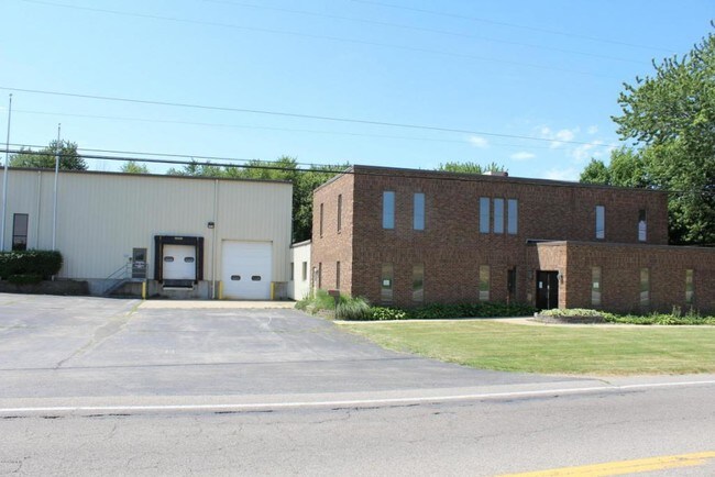
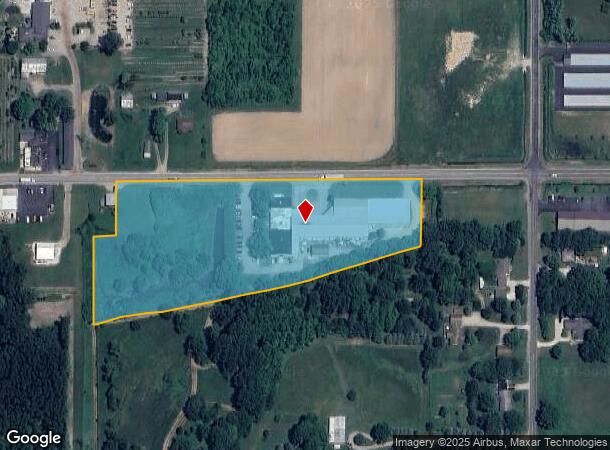
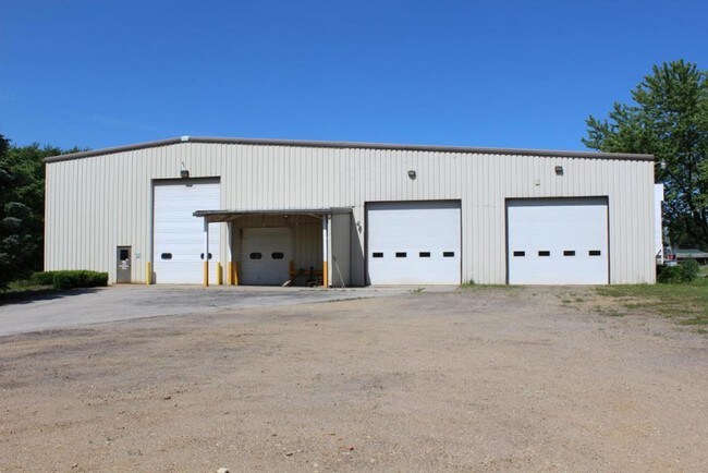
1010 W John Beers Rd
11-12-0026-0009-01-8
COM 157'S & 50'E OF NW COR OF NE1/4 OF NE1/4 OF SEC 26 T5S R19W TH E 66'TH N 124'TH E 889'TH S 184.5'TO C/L OF MORROW DRAIN TH SWLY ALONG C/L OF DRAIN TO PT S OF BEG TH N 300'TO BEG
Distributionwarehouseregional
Berrien
X
Michigan
26021C0115D
6.80 AC
2024
Michigan Southwest Area
2025
Other Market Areas
001700
Niles, MI
41,632 SF
DEMOGRAPHICS near 1010 W John Beers Rd
1 Mile
3 Mile
5 Mile
2024 Total Population
1,850
16,440
32,201
2029 Population
1,819
16,051
31,432
Pop Growth 2024-2029
(1.68%)
(2.37%)
(2.39%)
Average Age
42
43
43
2024 Total Households
708
6,511
13,249
HH Growth 2024-2029
(1.84%)
(2.52%)
(2.52%)
Median Household Inc
$91,718
$91,465
$86,356
Avg Household Size
2.40
2.40
2.40
2024 Avg HH Vehicles
2.00
2.00
2.00
Median Home Value
$275,735
$266,587
$250,644
Median Year Built
1983
1974
1972
Nearby Places
Map Layers
Map Styles
 Street
 Aerial
- Restaurants
- Banks
- Shops
- Fitness
- Groceries
PUBLIC TRANSPORTATION
COMMUTER RAIL
St. Joseph-Benton Harbor Amtrak Station (Pere Marquette - Amtrak)
DRIVE
WALK
Distance
St. Joseph-Benton Harbor Amtrak Station (Pere Marquette - Amtrak)
18 min
7.4 mi
AIRPORT
South Bend International
DRIVE
WALK
Distance
South Bend International
48 min
29.7 mi
Freight Ports
Port Milwaukee
DRIVE
WALK
Distance
Port Milwaukee
216 min
176.5 mi
SALE & LEASE HISTORY
LISTING DATE
SALE/LEASE

Sep 24, 2016
For Sale
Nearby Properties
Address
Land Use
TOTAL SIZE
Lot Size
Zoning
Address
Land Use
TOTAL SIZE
Lot Size
Zoning
195,253 SF
25.72 AC
HC
Address
Land Use
TOTAL SIZE
Lot Size
Zoning
45,270 SF
10.30 AC
C1 GEN COM
Address
Land Use
TOTAL SIZE
Lot Size
Zoning
49,527 SF
4.47 AC
PUD
Address
Land Use
TOTAL SIZE
Lot Size
Zoning
58,580 SF
1.99 AC
HC
Address
Land Use
TOTAL SIZE
Lot Size
Zoning
54,750 SF
5.87 AC
CMU
Address
Land Use
TOTAL SIZE
Lot Size
Zoning
9,136 SF
79.96 AC
MH
Address
Land Use
TOTAL SIZE
Lot Size
Zoning
62,721 SF
16.85 AC
CMU
Address
Land Use
TOTAL SIZE
Lot Size
Zoning
23,234 SF
3.94 AC
PUD
Address
Land Use
TOTAL SIZE
Lot Size
Zoning
29,032 SF
4.62 AC
C1 GEN COM
Address
Land Use
TOTAL SIZE
Lot Size
Zoning
49,162 SF
3.04 AC
HC
Address
Land Use
TOTAL SIZE
Lot Size
Zoning
128,076 SF
29.98 AC
LD
Address
Land Use
TOTAL SIZE
Lot Size
Zoning
28,344 SF
4.62 AC
C1 GEN COM
Address
Land Use
TOTAL SIZE
Lot Size
Zoning
Address
Land Use
TOTAL SIZE
Lot Size
Zoning
40,758 SF
9.20 AC
Address
Land Use
TOTAL SIZE
Lot Size
Zoning
55,682 SF
4.45 AC
HD
Address
Land Use
TOTAL SIZE
Lot Size
Zoning
19,110 SF
2.97 AC
CMU
Address
Land Use
TOTAL SIZE
Lot Size
Zoning
64,454 SF
4.72 AC
CMU
Address
Land Use
TOTAL SIZE
Lot Size
Zoning
29,932 SF
9.18 AC
CMU
Address
Land Use
TOTAL SIZE
Lot Size
Zoning
13,425 SF
2.14 AC
R1 - LD
Address
Land Use
TOTAL SIZE
Lot Size
Zoning
40,290 SF
1.65 AC
HC
Address
Land Use
TOTAL SIZE
Lot Size
Zoning
19,908 SF
13 AC
CMU
Address
Land Use
TOTAL SIZE
Lot Size
Zoning
34.16 AC
A - AG
Address
Land Use
TOTAL SIZE
Lot Size
Zoning
35,528 SF
2.76 AC
HC
Address
Land Use
TOTAL SIZE
Lot Size
Zoning
54,571 SF
5.64 AC
HD
Address
Land Use
TOTAL SIZE
Lot Size
Zoning
35,868 SF
2.15 AC
HC
Address
Land Use
TOTAL SIZE
Lot Size
Zoning
26,998 SF
6.35 AC
LD
Address
Land Use
TOTAL SIZE
Lot Size
Zoning
13,360 SF
1.61 AC
C1 GEN COM
Address
Land Use
TOTAL SIZE
Lot Size
Zoning
29,665 SF
10.74 AC
PUD
Address
Land Use
TOTAL SIZE
Lot Size
Zoning
59,433 SF
7.85 AC
R1
Address
Land Use
TOTAL SIZE
Lot Size
Zoning
30,240 SF
10 AC
LD
The World's #1 Commercial Real Estate Marketplace
Connect with us
© 2026 CoStar Group
The information above has been obtained from sources believed reliable. While we do not doubt its accuracy we have not verified it and make no guarantee, warranty or representation about it. It is your responsibility to independently confirm its accuracy and completeness. Any projections, opinions, assumptions, or estimates used are for example only and do not represent the current or future performance of the property. The value of this transaction to you depends on tax and other factors which should be evaluated by your tax, financial, and legal advisors. You and your advisors should conduct a careful, independent investigation of the property to determine to your satisfaction the suitability of the property for your needs.