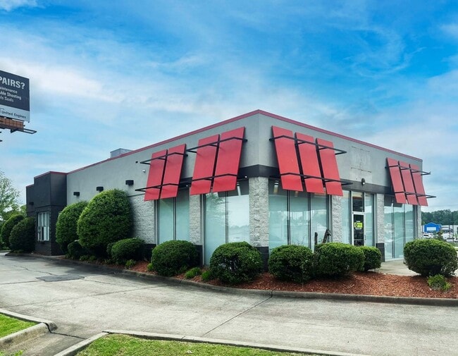
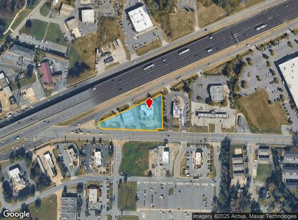
Property Record
10101 Interstate 30, Little Rock, AR 72209
Current Lease Availabilities
NEARBY LISTINGS FOR SALE OR LEASE
Property Detail
10101 Interstate 30
44L-195-00-046-01
Platted As Cwc
Commercialnec
PT SW SW BEG AT INTERS N R/W BASELINE RD & SLY R/W I-30 TH AL TH SLY AL I-30 N65*5629E454.34 S1*3508E226.64 TO N R/W BASELINE RD TH N87*5808W37.73 S2*0630W27.99 N87*5032W164.90 S89*0903W40.07 N87*5228W104.89 N84*4730W74.87 N2*011
X
Pulaski
05125C0250E
Arkansas
2025
1.35 AC
2025
Outlying Pulaski County
004103
Little Rock/N Little Rock
2,231 SF
Little Rock-North Little Rock-Conway, AR
DEMOGRAPHICS near 10101 Interstate 30
1 Mile
3 Mile
5 Mile
2024 Total Population
4,344
39,180
90,371
2029 Population
4,347
39,133
91,378
Pop Growth 2024-2029
+ 0.07%
(0.12%)
+ 1.11%
Average Age
34
35
37
2024 Total Households
1,660
14,973
35,940
HH Growth 2024-2029
+ 0.06%
(0.21%)
+ 1.14%
Median Household Inc
$42,041
$43,982
$44,809
Avg Household Size
2.60
2.50
2.40
2024 Avg HH Vehicles
2.00
2.00
2.00
Median Home Value
$85,890
$121,519
$130,612
Median Year Built
1972
1976
1979
Nearby Places
Map Layers
Map Styles
 Street
 Aerial
- Restaurants
- Banks
- Shops
- Fitness
- Groceries
PUBLIC TRANSPORTATION
AIRPORT
Bill and Hillary Clinton Ntl/Adams Field
DRIVE
WALK
Distance
Bill and Hillary Clinton Ntl/Adams Field
14 min
11.0 mi
Nearby Properties
Address
Land Use
TOTAL SIZE
Lot Size
Zoning
Address
Land Use
TOTAL SIZE
Lot Size
Zoning
189,729 SF
57.75 AC
Address
Land Use
TOTAL SIZE
Lot Size
Zoning
10 SF
29.02 AC
Address
Land Use
TOTAL SIZE
Lot Size
Zoning
177,413 SF
35.78 AC
Address
Land Use
TOTAL SIZE
Lot Size
Zoning
185,805 SF
8.29 AC
Address
Land Use
TOTAL SIZE
Lot Size
Zoning
317,302 SF
44.38 AC
Address
Land Use
TOTAL SIZE
Lot Size
Zoning
26,199 SF
19.22 AC
Address
Land Use
TOTAL SIZE
Lot Size
Zoning
201,039 SF
146.98 AC
Address
Land Use
TOTAL SIZE
Lot Size
Zoning
79,751 SF
28.57 AC
Address
Land Use
TOTAL SIZE
Lot Size
Zoning
239,345 SF
19.70 AC
Address
Land Use
TOTAL SIZE
Lot Size
Zoning
365,104 SF
29.75 AC
Address
Land Use
TOTAL SIZE
Lot Size
Zoning
104,359 SF
14.63 AC
Address
Land Use
TOTAL SIZE
Lot Size
Zoning
13,952 SF
12.35 AC
Address
Land Use
TOTAL SIZE
Lot Size
Zoning
34,925 SF
12.59 AC
Address
Land Use
TOTAL SIZE
Lot Size
Zoning
41,652 SF
10.86 AC
Address
Land Use
TOTAL SIZE
Lot Size
Zoning
4,104 SF
10.29 AC
Address
Land Use
TOTAL SIZE
Lot Size
Zoning
7,937 SF
5.50 AC
Address
Land Use
TOTAL SIZE
Lot Size
Zoning
201,499 SF
21.70 AC
Address
Land Use
TOTAL SIZE
Lot Size
Zoning
131,278 SF
6.37 AC
Address
Land Use
TOTAL SIZE
Lot Size
Zoning
139,410 SF
8.35 AC
Address
Land Use
TOTAL SIZE
Lot Size
Zoning
16,957 SF
6.04 AC
Address
Land Use
TOTAL SIZE
Lot Size
Zoning
24,520 SF
10.92 AC
Address
Land Use
TOTAL SIZE
Lot Size
Zoning
45,600 SF
6.45 AC
Address
Land Use
TOTAL SIZE
Lot Size
Zoning
46,180 SF
8.69 AC
Address
Land Use
TOTAL SIZE
Lot Size
Zoning
30,356 SF
5.42 AC
Address
Land Use
TOTAL SIZE
Lot Size
Zoning
64,182 SF
17.80 AC
Address
Land Use
TOTAL SIZE
Lot Size
Zoning
29,761 SF
7.08 AC
Address
Land Use
TOTAL SIZE
Lot Size
Zoning
33,216 SF
12.59 AC
Address
Land Use
TOTAL SIZE
Lot Size
Zoning
71,581 SF
10.69 AC
Address
Land Use
TOTAL SIZE
Lot Size
Zoning
11,762 SF
9.05 AC
Address
Land Use
TOTAL SIZE
Lot Size
Zoning
309,271 SF
41.75 AC
The World's #1 Commercial Real Estate Marketplace
Connect with us
© 2026 CoStar Group
The information above has been obtained from sources believed reliable. While we do not doubt its accuracy we have not verified it and make no guarantee, warranty or representation about it. It is your responsibility to independently confirm its accuracy and completeness. Any projections, opinions, assumptions, or estimates used are for example only and do not represent the current or future performance of the property. The value of this transaction to you depends on tax and other factors which should be evaluated by your tax, financial, and legal advisors. You and your advisors should conduct a careful, independent investigation of the property to determine to your satisfaction the suitability of the property for your needs.