Property Record
10101 Lymestone Ct, New Smyrna Beach, FL 32168

NEARBY LISTINGS FOR SALE OR LEASE
-
-
View all New Smyrna Beach listings for sale on LoopNet.com
Property Detail
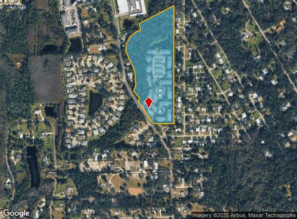
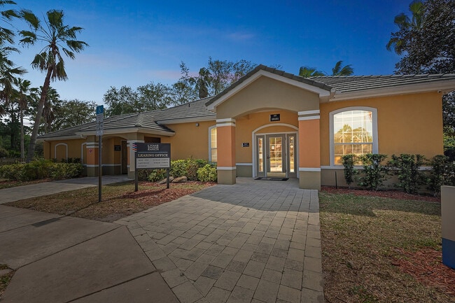
10101 Lymestone Ct
Deltona-Daytona Beach-Ormond Beach, FL
Co Rd Sub
7323-03-00-0014
23-17-33 LOTS 1 & 2 E OF GLENCOE RD EXC N 400 FT OF S 682 FT OF W 300 FT & EXC N 400 FT OF S 1132.8 FT OF W 300 FT & LOT 12 E OF GLENCOE RD EXC S 330 FT & EXC 50 FT R/W FOR CO RD SUB SW 1/4 PER OR 2670 PG 1801 & EXC IRREG PARCEL PER OR 3927 PG 0750 M
Multifamilydwelling
Volusia
A
Florida
12127C0540J
1,2
2025
2 AC
2026
Outer SE Volusia County
082902
Deltona/Daytona Beach
218,901 SF
DEMOGRAPHICS near 10101 Lymestone Ct
1 Mile
3 Mile
5 Mile
2024 Total Population
2,859
19,553
50,740
2029 Population
3,196
21,923
57,006
Pop Growth 2024-2029
+ 11.79%
+ 12.12%
+ 12.35%
Average Age
46
47
49
2024 Total Households
1,288
8,886
23,375
HH Growth 2024-2029
+ 12.03%
+ 12.26%
+ 12.63%
Median Household Inc
$74,387
$58,632
$61,619
Avg Household Size
2.10
2.10
2.10
2024 Avg HH Vehicles
2.00
2.00
2.00
Median Home Value
$275,819
$256,004
$286,288
Median Year Built
2000
1989
1988
Nearby Places
Map Layers
Map Styles
 Street
 Aerial
- Restaurants
- Banks
- Shops
- Fitness
- Groceries
PUBLIC TRANSPORTATION
AIRPORT
Daytona Beach International
DRIVE
WALK
Distance
Daytona Beach International
23 min
16.1 mi
Orlando Sanford International
DRIVE
WALK
Distance
Orlando Sanford International
44 min
29.9 mi
Freight Ports
Port Canaveral
DRIVE
WALK
Distance
Port Canaveral
69 min
58.6 mi
Nearby Properties
Address
Land Use
TOTAL SIZE
Lot Size
Zoning
Address
Land Use
TOTAL SIZE
Lot Size
Zoning
360,394 SF
65.63 AC
01R4
Address
Land Use
TOTAL SIZE
Lot Size
Zoning
317,281 SF
21.97 AC
RR
Address
Land Use
TOTAL SIZE
Lot Size
Zoning
177,619 SF
6.91 AC
10R2
Address
Land Use
TOTAL SIZE
Lot Size
Zoning
108,577 SF
20 AC
10R2
Address
Land Use
TOTAL SIZE
Lot Size
Zoning
209,027 SF
29.13 AC
10R2A
Address
Land Use
TOTAL SIZE
Lot Size
Zoning
150,044 SF
19.80 AC
R4
Address
Land Use
TOTAL SIZE
Lot Size
Zoning
162,622 SF
20.33 AC
B62
Address
Land Use
TOTAL SIZE
Lot Size
Zoning
91,509 SF
4.06 AC
I1
Address
Land Use
TOTAL SIZE
Lot Size
Zoning
7,345 SF
0.43 AC
MH1
Address
Land Use
TOTAL SIZE
Lot Size
Zoning
91,759 SF
10.15 AC
10B2
Address
Land Use
TOTAL SIZE
Lot Size
Zoning
110,926 SF
7.02 AC
Address
Land Use
TOTAL SIZE
Lot Size
Zoning
51,507 SF
10.61 AC
B3C
Address
Land Use
TOTAL SIZE
Lot Size
Zoning
43,852 SF
8.81 AC
RR
Address
Land Use
TOTAL SIZE
Lot Size
Zoning
111,686 SF
10.03 AC
10B5
Address
Land Use
TOTAL SIZE
Lot Size
Zoning
47,434 SF
11.41 AC
10R3
Address
Land Use
TOTAL SIZE
Lot Size
Zoning
119,537 SF
12.06 AC
PUD
Address
Land Use
TOTAL SIZE
Lot Size
Zoning
55,587 SF
85.39 AC
R4
Address
Land Use
TOTAL SIZE
Lot Size
Zoning
65.13 AC
Address
Land Use
TOTAL SIZE
Lot Size
Zoning
115,028 SF
16.51 AC
R4
Address
Land Use
TOTAL SIZE
Lot Size
Zoning
229,941 SF
0.57 AC
10R2A
Address
Land Use
TOTAL SIZE
Lot Size
Zoning
44,239 SF
2.31 AC
10B1
Address
Land Use
TOTAL SIZE
Lot Size
Zoning
108,762 SF
11.60 AC
RA
Address
Land Use
TOTAL SIZE
Lot Size
Zoning
32,198 SF
1.88 AC
A3C2
Address
Land Use
TOTAL SIZE
Lot Size
Zoning
70,088 SF
0.30 AC
10R5
Address
Land Use
TOTAL SIZE
Lot Size
Zoning
73,711 SF
7.06 AC
R2
Address
Land Use
TOTAL SIZE
Lot Size
Zoning
53,157 SF
75.97 AC
I2
Address
Land Use
TOTAL SIZE
Lot Size
Zoning
79,518 SF
8.69 AC
B3
Address
Land Use
TOTAL SIZE
Lot Size
Zoning
56,841 SF
8.81 AC
B4C
Address
Land Use
TOTAL SIZE
Lot Size
Zoning
33,031 SF
0.55 AC
10R4
The World's #1 Commercial Real Estate Marketplace
Connect with us
© 2026 CoStar Group
The information above has been obtained from sources believed reliable. While we do not doubt its accuracy we have not verified it and make no guarantee, warranty or representation about it. It is your responsibility to independently confirm its accuracy and completeness. Any projections, opinions, assumptions, or estimates used are for example only and do not represent the current or future performance of the property. The value of this transaction to you depends on tax and other factors which should be evaluated by your tax, financial, and legal advisors. You and your advisors should conduct a careful, independent investigation of the property to determine to your satisfaction the suitability of the property for your needs.