Property Record
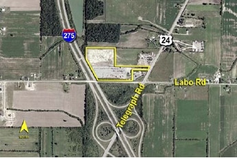
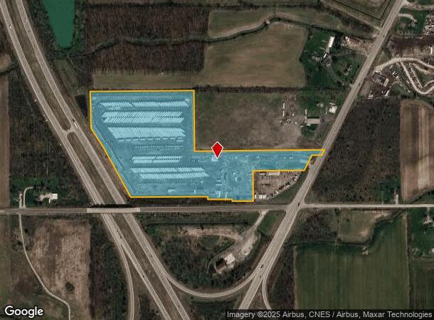
10101 Telegraph Rd, Carleton, MI 48117
NEARBY LISTINGS FOR SALE OR LEASE
Property Detail
10101 Telegraph Rd
01-027-030-10
A PARCEL OF LAND BEING PART OF THE SE 1/4 OF SEC 27, T5S R9E, COM AT THE SW COR OF THE SE 1/4 OF SEC 27; TH N 89 DEG 23' 31"
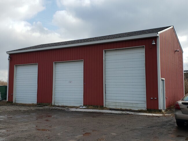
Storageyardopenstoragelightequipmentmaterial
Monroe
X
Michigan
26115C0113E
20.77 AC
2025
Monroe County
2025
Detroit
830300
Monroe, MI
3,360 SF
DEMOGRAPHICS near 10101 Telegraph Rd
1 Mile
3 Mile
5 Mile
2024 Total Population
689
12,539
24,206
2029 Population
703
12,811
24,754
Pop Growth 2024-2029
+ 2.03%
+ 2.17%
+ 2.26%
Average Age
40
39
41
2024 Total Households
257
4,785
9,389
HH Growth 2024-2029
+ 1.95%
+ 2.19%
+ 2.30%
Median Household Inc
$67,058
$60,519
$68,867
Avg Household Size
2.60
2.60
2.50
2024 Avg HH Vehicles
2.00
2.00
2.00
Median Home Value
$233,561
$158,947
$216,532
Median Year Built
1993
1994
1991
Nearby Places
Map Layers
Map Styles
 Street
 Aerial
- Restaurants
- Banks
- Shops
- Fitness
- Groceries
PUBLIC TRANSPORTATION
AIRPORT
Detroit Metro Wayne County
DRIVE
WALK
Distance
Detroit Metro Wayne County
19 min
15.6 mi
Windsor International
DRIVE
WALK
Distance
Windsor International
58 min
37.0 mi
Freight Ports
Port of Toledo
DRIVE
WALK
Distance
Port of Toledo
43 min
32.9 mi
SALE & LEASE HISTORY
LISTING DATE
SALE/LEASE

Jan 30, 2020
For Lease
Nearby Properties
Address
Land Use
TOTAL SIZE
Lot Size
Zoning
Address
Land Use
TOTAL SIZE
Lot Size
Zoning
Address
Land Use
TOTAL SIZE
Lot Size
Zoning
453,206 SF
156.60 AC
AG
Address
Land Use
TOTAL SIZE
Lot Size
Zoning
Address
Land Use
TOTAL SIZE
Lot Size
Zoning
720,420 SF
71.34 AC
LM-LIGHT M
Address
Land Use
TOTAL SIZE
Lot Size
Zoning
5,216 SF
81.10 AC
MHP
Address
Land Use
TOTAL SIZE
Lot Size
Zoning
29.81 AC
MHP
Address
Land Use
TOTAL SIZE
Lot Size
Zoning
41,920 SF
48.72 AC
Address
Land Use
TOTAL SIZE
Lot Size
Zoning
2,100 SF
36.48 AC
MHP
Address
Land Use
TOTAL SIZE
Lot Size
Zoning
100,407 SF
16.34 AC
Address
Land Use
TOTAL SIZE
Lot Size
Zoning
4,419 SF
64.34 AC
MHP
Address
Land Use
TOTAL SIZE
Lot Size
Zoning
28.87 AC
MHP
Address
Land Use
TOTAL SIZE
Lot Size
Zoning
100,918 SF
14.41 AC
Address
Land Use
TOTAL SIZE
Lot Size
Zoning
3,272 SF
121.75 AC
MHP
Address
Land Use
TOTAL SIZE
Lot Size
Zoning
26.52 AC
MHP
Address
Land Use
TOTAL SIZE
Lot Size
Zoning
91,075 SF
9.07 AC
Address
Land Use
TOTAL SIZE
Lot Size
Zoning
39,078 SF
2.08 AC
Address
Land Use
TOTAL SIZE
Lot Size
Zoning
2,472 SF
46.65 AC
Address
Land Use
TOTAL SIZE
Lot Size
Zoning
21,528 SF
12.61 AC
Address
Land Use
TOTAL SIZE
Lot Size
Zoning
37,665 SF
9.13 AC
Address
Land Use
TOTAL SIZE
Lot Size
Zoning
36,604 SF
3.96 AC
Address
Land Use
TOTAL SIZE
Lot Size
Zoning
5,712 SF
0.84 AC
Address
Land Use
TOTAL SIZE
Lot Size
Zoning
37,447 SF
4.71 AC
Address
Land Use
TOTAL SIZE
Lot Size
Zoning
10,717 SF
8.60 AC
Address
Land Use
TOTAL SIZE
Lot Size
Zoning
34.40 AC
MHP
Address
Land Use
TOTAL SIZE
Lot Size
Zoning
14,118 SF
37.23 AC
Address
Land Use
TOTAL SIZE
Lot Size
Zoning
3,136 SF
3.92 AC
Address
Land Use
TOTAL SIZE
Lot Size
Zoning
16,239 SF
2.71 AC
Address
Land Use
TOTAL SIZE
Lot Size
Zoning
13,730 SF
2.43 AC
Address
Land Use
TOTAL SIZE
Lot Size
Zoning
9,146 SF
1.86 AC
Address
Land Use
TOTAL SIZE
Lot Size
Zoning
13,500 SF
2.34 AC
The World's #1 Commercial Real Estate Marketplace
Connect with us
© 2026 CoStar Group
The information above has been obtained from sources believed reliable. While we do not doubt its accuracy we have not verified it and make no guarantee, warranty or representation about it. It is your responsibility to independently confirm its accuracy and completeness. Any projections, opinions, assumptions, or estimates used are for example only and do not represent the current or future performance of the property. The value of this transaction to you depends on tax and other factors which should be evaluated by your tax, financial, and legal advisors. You and your advisors should conduct a careful, independent investigation of the property to determine to your satisfaction the suitability of the property for your needs.