Property Record
10101 Venice Ave, Sturtevant, WI 53177
NEARBY LISTINGS FOR SALE OR LEASE
Property Detail
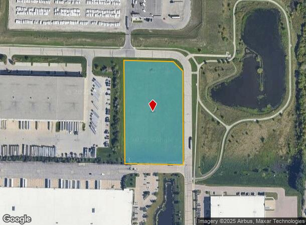
10101 Venice Ave
Racine, WI
Certified Survey Map No 2367
181-032221007015
PT NW1/4 CSM 2367 V7 P327 LOT 2 FROM 181032221004010 IN 98 FOR 99 ROLL **TOTAL ACRES** 4.56
Farms
Racine
X
Wisconsin
55101C0208E
2
2024
4.56 AC
2024
Racine East
001703
Milwaukee/Madison
DEMOGRAPHICS near 10101 Venice Ave
1 Mile
3 Mile
5 Mile
2024 Total Population
3,190
16,349
67,201
2029 Population
3,126
16,259
66,646
Pop Growth 2024-2029
(2.01%)
(0.55%)
(0.83%)
Average Age
41
43
42
2024 Total Households
735
6,532
27,286
HH Growth 2024-2029
(1.09%)
(0.28%)
(0.85%)
Median Household Inc
$58,222
$71,951
$70,148
Avg Household Size
2.40
2.20
2.30
2024 Avg HH Vehicles
2.00
2.00
2.00
Median Home Value
$158,309
$223,347
$213,267
Median Year Built
1968
1981
1972
Nearby Places
Map Layers
Map Styles
 Street
 Aerial
- Restaurants
- Banks
- Shops
- Fitness
- Groceries
PUBLIC TRANSPORTATION
COMMUTER RAIL
DRIVE
WALK
Distance
4 min
1.3 mi
AIRPORT
General Mitchell International
DRIVE
WALK
Distance
General Mitchell International
28 min
20.6 mi
Freight Ports
Port Milwaukee
DRIVE
WALK
Distance
Port Milwaukee
33 min
24.4 mi
Nearby Properties
Address
Land Use
TOTAL SIZE
Lot Size
Zoning
Address
Land Use
TOTAL SIZE
Lot Size
Zoning
861.42 AC
Address
Land Use
TOTAL SIZE
Lot Size
Zoning
318.64 AC
Address
Land Use
TOTAL SIZE
Lot Size
Zoning
22.34 AC
Address
Land Use
TOTAL SIZE
Lot Size
Zoning
Address
Land Use
TOTAL SIZE
Lot Size
Zoning
241.29 AC
Address
Land Use
TOTAL SIZE
Lot Size
Zoning
241.29 AC
Address
Land Use
TOTAL SIZE
Lot Size
Zoning
Address
Land Use
TOTAL SIZE
Lot Size
Zoning
9.40 AC
B-3
Address
Land Use
TOTAL SIZE
Lot Size
Zoning
23.10 AC
Address
Land Use
TOTAL SIZE
Lot Size
Zoning
37.55 AC
Address
Land Use
TOTAL SIZE
Lot Size
Zoning
47.01 AC
M-1
Address
Land Use
TOTAL SIZE
Lot Size
Zoning
32.55 AC
Address
Land Use
TOTAL SIZE
Lot Size
Zoning
57.80 AC
M1
Address
Land Use
TOTAL SIZE
Lot Size
Zoning
26.79 AC
Address
Land Use
TOTAL SIZE
Lot Size
Zoning
Address
Land Use
TOTAL SIZE
Lot Size
Zoning
Address
Land Use
TOTAL SIZE
Lot Size
Zoning
23.21 AC
Address
Land Use
TOTAL SIZE
Lot Size
Zoning
140.07 AC
Address
Land Use
TOTAL SIZE
Lot Size
Zoning
9.31 AC
Address
Land Use
TOTAL SIZE
Lot Size
Zoning
Address
Land Use
TOTAL SIZE
Lot Size
Zoning
30.45 AC
002
Address
Land Use
TOTAL SIZE
Lot Size
Zoning
13.04 AC
Address
Land Use
TOTAL SIZE
Lot Size
Zoning
18.33 AC
Address
Land Use
TOTAL SIZE
Lot Size
Zoning
10.72 AC
Address
Land Use
TOTAL SIZE
Lot Size
Zoning
20.61 AC
Address
Land Use
TOTAL SIZE
Lot Size
Zoning
19.29 AC
002
Address
Land Use
TOTAL SIZE
Lot Size
Zoning
5.74 AC
Address
Land Use
TOTAL SIZE
Lot Size
Zoning
Address
Land Use
TOTAL SIZE
Lot Size
Zoning
Address
Land Use
TOTAL SIZE
Lot Size
Zoning
22.98 AC
M-1
The World's #1 Commercial Real Estate Marketplace
Connect with us
© 2025 CoStar Group
The information above has been obtained from sources believed reliable. While we do not doubt its accuracy we have not verified it and make no guarantee, warranty or representation about it. It is your responsibility to independently confirm its accuracy and completeness. Any projections, opinions, assumptions, or estimates used are for example only and do not represent the current or future performance of the property. The value of this transaction to you depends on tax and other factors which should be evaluated by your tax, financial, and legal advisors. You and your advisors should conduct a careful, independent investigation of the property to determine to your satisfaction the suitability of the property for your needs.