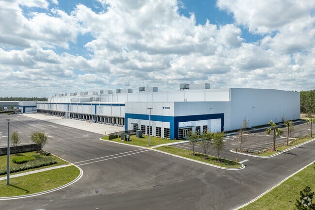
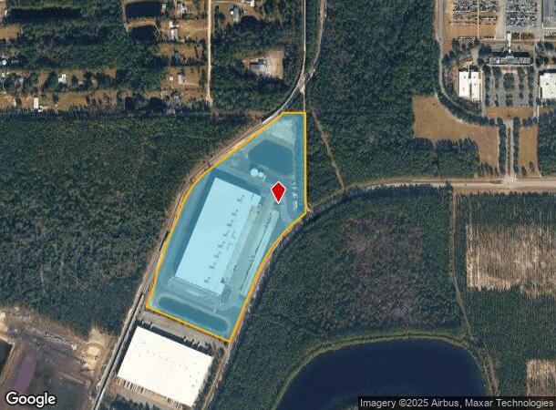
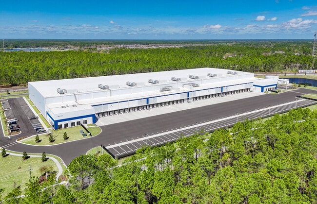
Property Record
10105 Pritchard Rd, Jacksonville, FL 32219
Current Lease Availabilities
NEARBY LISTINGS FOR SALE OR LEASE
Property Detail
10105 Pritchard Rd
Jacksonville, FL
Section Land
003322-0070
31-1S-25E 24.17 PT NE1/4 RECD O/R 20730-246
Warehouse
Duval
2025
Florida
2026
25.05 AC
010601
West Side
267,204 SF
Jacksonville (Florida)
DEMOGRAPHICS near 10105 Pritchard Rd
1 Mile
3 Mile
5 Mile
2024 Total Population
202
4,259
21,437
2029 Population
219
4,663
22,853
Pop Growth 2024-2029
+ 8.42%
+ 9.49%
+ 6.61%
Average Age
43
42
41
2024 Total Households
78
1,596
7,917
HH Growth 2024-2029
+ 8.97%
+ 9.59%
+ 6.72%
Median Household Inc
$81,250
$72,939
$67,775
Avg Household Size
2.60
2.70
2.70
2024 Avg HH Vehicles
2.00
2.00
2.00
Median Home Value
$250,000
$252,539
$225,126
Median Year Built
2000
2003
1996
Nearby Places
Map Layers
Map Styles
 Street
 Aerial
- Restaurants
- Banks
- Shops
- Fitness
- Groceries
PUBLIC TRANSPORTATION
COMMUTER RAIL
Jacksonville (Silver Meteor - Amtrak, Silver Star - Amtrak)
DRIVE
WALK
Distance
Jacksonville (Silver Meteor - Amtrak, Silver Star - Amtrak)
15 min
8.2 mi
AIRPORT
Jacksonville International
DRIVE
WALK
Distance
Jacksonville International
28 min
17.3 mi
Freight Ports
Jacksonville Port
DRIVE
WALK
Distance
Jacksonville Port
26 min
14.4 mi
Nearby Properties
Address
Land Use
TOTAL SIZE
Lot Size
Zoning
Address
Land Use
TOTAL SIZE
Lot Size
Zoning
1,013,036 SF
51.67 AC
PUD
Address
Land Use
TOTAL SIZE
Lot Size
Zoning
773,806 SF
68.14 AC
PUD
Address
Land Use
TOTAL SIZE
Lot Size
Zoning
548,235 SF
64.22 AC
PUD
Address
Land Use
TOTAL SIZE
Lot Size
Zoning
491,247 SF
30.77 AC
PUD
Address
Land Use
TOTAL SIZE
Lot Size
Zoning
457,353 SF
250.89 AC
PUD
Address
Land Use
TOTAL SIZE
Lot Size
Zoning
435,150 SF
21.92 AC
PUD
Address
Land Use
TOTAL SIZE
Lot Size
Zoning
421,500 SF
43.21 AC
PUD
Address
Land Use
TOTAL SIZE
Lot Size
Zoning
496,042 SF
120 AC
PUD
Address
Land Use
TOTAL SIZE
Lot Size
Zoning
449,367 SF
26.16 AC
PUD
Address
Land Use
TOTAL SIZE
Lot Size
Zoning
414,674 SF
21.03 AC
PUD
Address
Land Use
TOTAL SIZE
Lot Size
Zoning
401,680 SF
39.78 AC
PUD
Address
Land Use
TOTAL SIZE
Lot Size
Zoning
343,650 SF
9.45 AC
PUD
Address
Land Use
TOTAL SIZE
Lot Size
Zoning
307,322 SF
19.31 AC
PUD
Address
Land Use
TOTAL SIZE
Lot Size
Zoning
311,382 SF
18.57 AC
PUD
Address
Land Use
TOTAL SIZE
Lot Size
Zoning
273,608 SF
23.15 AC
PUD
Address
Land Use
TOTAL SIZE
Lot Size
Zoning
237,368 SF
14.55 AC
PUD
Address
Land Use
TOTAL SIZE
Lot Size
Zoning
235,950 SF
18.10 AC
PUD
Address
Land Use
TOTAL SIZE
Lot Size
Zoning
263,550 SF
29.32 AC
PUD
Address
Land Use
TOTAL SIZE
Lot Size
Zoning
1,265.67 AC
PUD
Address
Land Use
TOTAL SIZE
Lot Size
Zoning
197,164 SF
13.35 AC
PUD
Address
Land Use
TOTAL SIZE
Lot Size
Zoning
187,242 SF
18.73 AC
PUD
Address
Land Use
TOTAL SIZE
Lot Size
Zoning
216,022 SF
15.36 AC
PUD
Address
Land Use
TOTAL SIZE
Lot Size
Zoning
244,454 SF
11.66 AC
PUD
Address
Land Use
TOTAL SIZE
Lot Size
Zoning
274,925 SF
19.70 AC
PUD
Address
Land Use
TOTAL SIZE
Lot Size
Zoning
167,992 SF
12.63 AC
PUD
Address
Land Use
TOTAL SIZE
Lot Size
Zoning
236,224 SF
14.13 AC
PUD
Address
Land Use
TOTAL SIZE
Lot Size
Zoning
214,392 SF
11.29 AC
PUD
Address
Land Use
TOTAL SIZE
Lot Size
Zoning
171,413 SF
10.39 AC
PUD
Address
Land Use
TOTAL SIZE
Lot Size
Zoning
140,558 SF
8.52 AC
PUD
The World's #1 Commercial Real Estate Marketplace
Connect with us
© 2026 CoStar Group
The information above has been obtained from sources believed reliable. While we do not doubt its accuracy we have not verified it and make no guarantee, warranty or representation about it. It is your responsibility to independently confirm its accuracy and completeness. Any projections, opinions, assumptions, or estimates used are for example only and do not represent the current or future performance of the property. The value of this transaction to you depends on tax and other factors which should be evaluated by your tax, financial, and legal advisors. You and your advisors should conduct a careful, independent investigation of the property to determine to your satisfaction the suitability of the property for your needs.